IOCCG News
2020 Summer Lecture Series
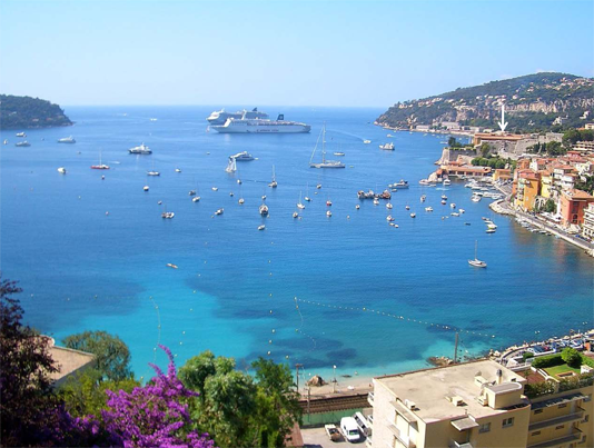
Applications are now open for the 2020 IOCCG Summer Lecture Series (SLS-2020). The course will take place from 22 June – 3 July 2020 at the Laboratoire d’Océanographie de Villefranche (LOV) in France, which is part of the IMEV (Institut de la Mer, de Villefranche), and hosts the Marine Optics and Remote Sensing group (MORS). The course will provide lectures on cutting edge research, focusing on current critical issues in ocean colour science, as well as interactive discussion sessions between students and lecturers.
Students will also learn how to collect high-quality in situ data, and how to interpret the measurements through several practical lab sessions. Note that the IOCCG Summer Lecture Series is designed as an advanced training course addressing theoretical aspects and advanced science questions, rather than focusing primarily on practical applications. For more information see the SLS-2020 course website.
To apply, please complete the online application form at: https://ioccg.org/2020-sls-form/. You will be requested to provide your personal information as well as a brief CV and a concise motivation statement. Course participation is limited to around 20 students to provide maximum exposure for the trainees. The deadline for course applications is 23 February 2020.
New IOCCG Reports
 Two reports have recently been published in the IOCCG Report Series. IOCCG Report 18 on “Uncertainties in Ocean Colour Remote Sensing” (edited by Frédéric Mélin, EC, JRC) summarizes the state of our knowledge on uncertainties related to ocean colour (OC) products, and identifies ideas and recommendations to achieve significant progress on how uncertainties are quantified and distributed. For a proper use of OC data, it is necessary to be aware of the potential problems and limitations associated with OC remote sensing products, and to identify the sources contributing to their uncertainties, from top-of-atmosphere (TOA) data, to gridded products. This report makes a comprehensive review of these factors. Even though very few OC products are distributed with uncertainty estimates, several approaches have been proposed in recent years to quantify OC product uncertainties, which are reviewed in the report, along with general recommendations for promoting a better treatment of uncertainties, as well as reducing the uncertainties associated with ocean colour products. A digital copy of the report can be downloaded directly from the IOCCG website at: https://ioccg.org/what-we-do/ioccg-publications/ioccg-reports/.
 IOCCG Report 19 on “Synergy between Ocean Colour and Biogeochemical/Ecosystem Models” (edited by Stephanie Dutkiewicz, MIT, USA) aims to improve the communication between numerical modellers and the ocean colour community. It provides non-expert accessible information about both ocean colour and biogeochemical and ecosystem modelling. The report discusses methods of model skill assessment using ocean colour products, introduces and highlights case studies of data assimilation involving ocean colour products, and provides examples where models and ocean colour are used synergistically to better understand processes and trends in the ocean’s ecosystem and biogeochemistry. Additionally, the report explores how models can help inform on ocean colour, with the goal of fostering further use of models in ocean colour studies, in helping elucidate uncertainties, and in algorithm development. A digital copy of the report can be downloaded directly from the IOCCG website at: https://ioccg.org/what-we-do/ioccg-publications/ioccg-reports/
Hard copies of both reports can also be requested by completing the IOCCG Report Request Form. A limited number of reports will be printed, so hard copies may not be available at a later date. Please provide detailed mailing information and use an address that will still be valid in a few months’ time..
IOCCG Protocol Series
The IOCCG Protocol Series provides updated versions of the NASA Ocean Optics Protocols for Satellite Ocean Color Sensor Validation, as well as new material, all of which are vetted and reviewed by the international ocean colour community. To date, four volumes have been published, addressing protocols for measuring:
1. Absorption Coefficient (Vol. 1)
2. Beam Transmission and Attenuation Coefficients (Vol. 2)
3. In Situ Optical Radiometry (Vol. 3)
4. Ship-Based Underway Flow-Through Optical Data (Vol. 4).
Recently, the community review period closed for two other draft protocols on Absorption by CDOM (Vol. 5) and Particulate Organic Carbon (Vol. 6). These two documents will be revised according to the comments received, and the final versions of the protocols will be posted on the IOCCG website in the near future.
News from NOAA
![]()
New Product
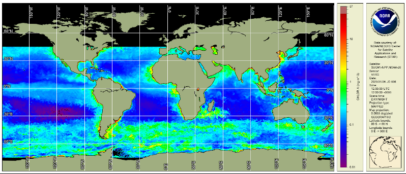
The new VIIRS, multi-sensor (SNPP + NOAA-20) global, daily, gap-filled analysis (i.e., level 4) chlorophyll-a concentration product based on NOAA’s MSL12 ocean color processing and the application of the DINEOF interpolation method is now available through the NOAA CoastWatch data access pages. This product was featured in the recent EOS article by Mikelsons et al., 2019. CoastWatch data access links and product information can be found at the tabs within the Ocean Color, science quality, VIIRS, multi-sensor gap-filled analysis product page. Also, take a look at the 6-month animation at the NOAA Ocean Color science team’s site.
GEO Individual Excellence Award
Paul DiGiacomo, the past NOAA representative on the IOCCG Committee, was recently awarded the first GEO Individual Excellence Award as the GEO Blue Planet Steering Committee Co-Chair! The GEO Individual Excellence Awards award recognizes those individuals who have demonstrated exceptional personal commitment to GEO and whose work is making a real impact in the community. Paul has been a champion for water quality observations in GEO and has been instrumental to the development of two GEO Initiatives – GEO Blue Planet and GEO AquaWatch – into active and impactful activities. His work is making real strides in advancing the use of Earth observations for water resource management. Congratulations to Paul from the entire ocean colour community!
News from ESA
Biological Pump and Carbon Exchange Processes (BICEP)
 The Biological Pump and Carbon Exchange Processes (BICEP) project from the European Space Agency has been kicked-off on Friday, January 17th in ESRIN, Rome, Italy.
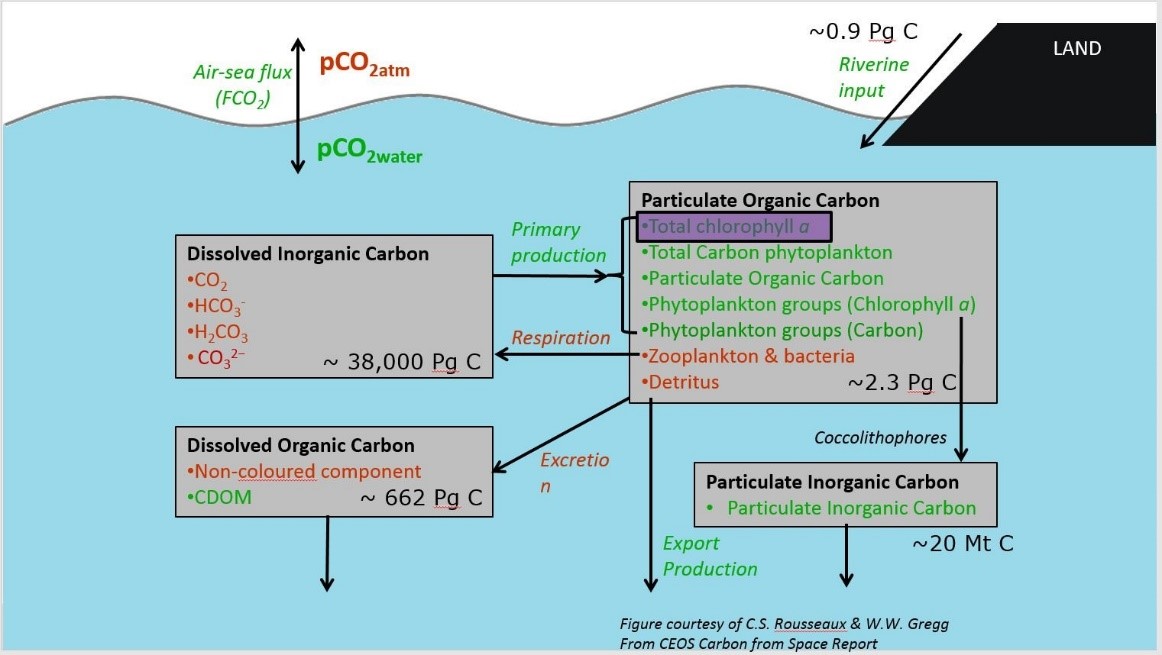
The ocean carbon cycle is a vital part of the global carbon cycle. It has been estimated that around a quarter of anthropogenically-produced emissions of CO2, caused from the burning of fossil fuels and land use change, have been absorbed by the ocean. On the other hand, significant advances have been made recently to expand and enhance the quality of a wide range of Remote Sensing based products capturing different aspects of the ocean carbon cycle.
In this context, the objective of the BICEP project is to bring these developments together into an holistic exercise to further advance our capacity to better characterise the different components of the ocean biological carbon pump (see in the figure above, in green, all components of the ocean surface carbon cycle where space observation may contribute), its pools and fluxes, its variability in space and time and the understanding of its processes and interactions with the earth system.
The proposed work will be delivered by a consortium of twelve international Institutes, led by the Plymouth Marine Laboratory (PML, Plymouth, UK) and composed of top-level scientists, with collective expertise on Remote Sensing, statistical modelling, ocean carbon cycling, theoretical ecology and Earth System science.
News from EUMETSAT and ESA
Sentinel-3 Validation Team Meeting
 Registration and abstract submission is now open for the 6th Sentinel-3 Validation Team Meeting (S3VT), which will be held from 10-12 March 2020 at EUMETSAT HQ, Darmstadt, Germany! You are invited to submit your abstract through the conference website. The abstracts submission deadline is 31 January 2020. Participants can register for the meeting using the online registration tool on the conference website. The registration deadline is 20 February 2020, however space is limited to 140 participants and once it is filled up, the registration will be closed earlier. For more information please visit the meeting website: https://www.eventsforce.net/s3vt or contact the local organising committee at s3vtm@eumetsat.int.
News from ISRO
![]() The Indian Space Research Organization (ISRO) is scheduled to launch the geostationary GEO Imaging Satellite (GISAT-1) during February 2020. GISAT-1 will operate in an orbital slot around 93.5° east, and will provide continuous observation of the Indian sub-continent, supporting rapid monitoring of natural hazards and disasters. The mission will carry imaging payloads capable of providing multi-spectral (visible, near infra-red and thermal) and hyperspectral images ( visible, near infrared and shortwave infrared (SWIR) bands) with multi-resolution (50 m to 1.5 km ). GISAT-1 will image the entire area every 30 minutes providing near real time images. A second satellite, GISAT-2, is planned to be a repeat of the first satellite.
The Indian Space Research Organization (ISRO) is scheduled to launch the geostationary GEO Imaging Satellite (GISAT-1) during February 2020. GISAT-1 will operate in an orbital slot around 93.5° east, and will provide continuous observation of the Indian sub-continent, supporting rapid monitoring of natural hazards and disasters. The mission will carry imaging payloads capable of providing multi-spectral (visible, near infra-red and thermal) and hyperspectral images ( visible, near infrared and shortwave infrared (SWIR) bands) with multi-resolution (50 m to 1.5 km ). GISAT-1 will image the entire area every 30 minutes providing near real time images. A second satellite, GISAT-2, is planned to be a repeat of the first satellite.
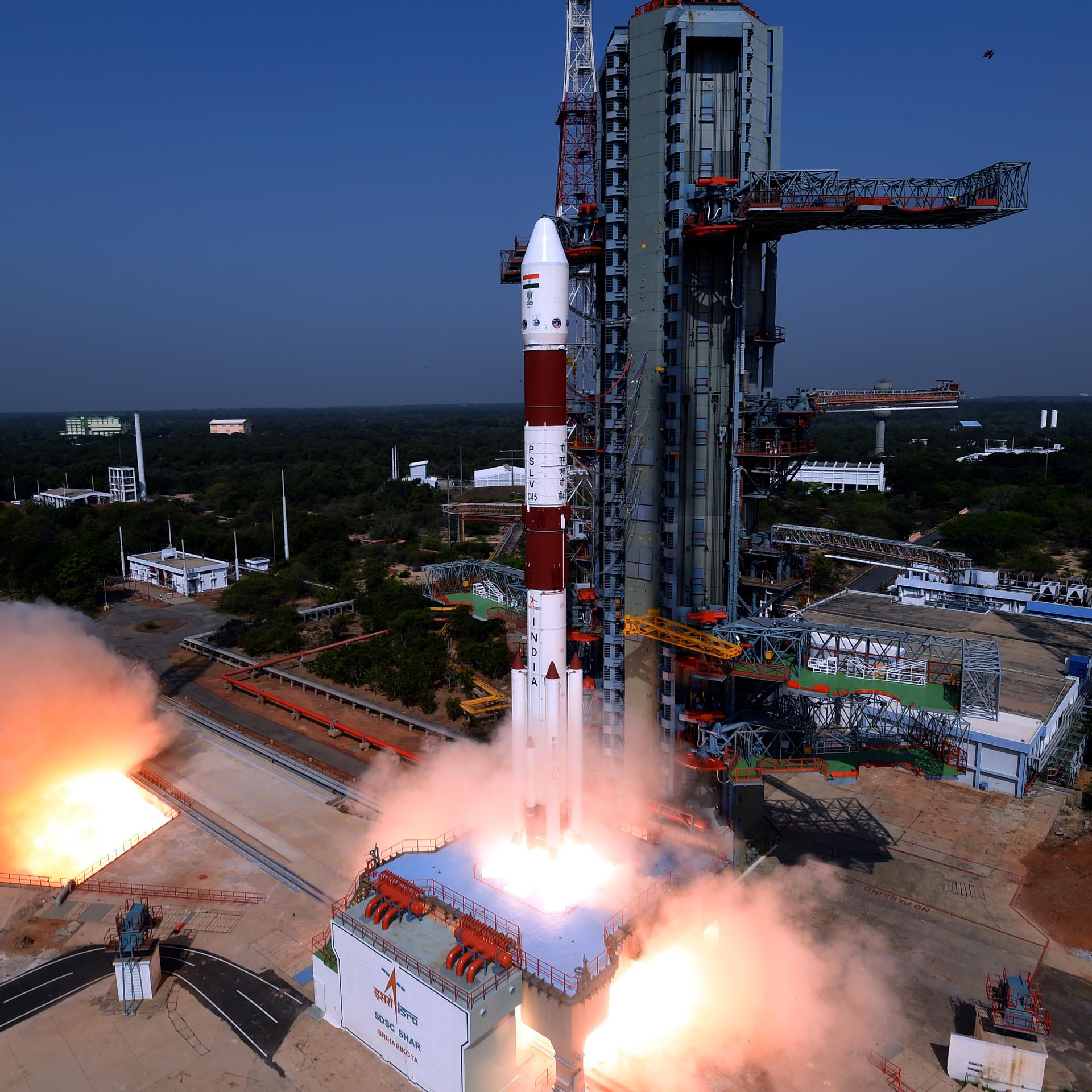 Later this year, ISRO is also scheduled to launch the Oceansat-3 mission (tentatively between June – October, 2020) from the Satish Dhawan Space Centre. The payload for Oceansat-3 consists of three instruments, including the 13-band Ocean Colour Monitor (OCM, 360 m spatial resolution). These instruments will collect data on ocean colour, sea surface temperature and wind vector data. Oceansat-3 (and the follow-on Oceansat-3A mission, to be launched in 2020/2021) is envisaged to provide service continuity for operational users of OCM data from Oceansat-2, as well as to enhance operational services like potential fishery zone (PFZ) advisories, using simultaneous ocean colour (chl) and sea surface temperature (SST) measurements. Oceansat-3 is a global mission and is configured to cover global oceans. The mission, in tandem with Oceansat-2, will improve the revisit frequency of ocean colour measurements to every 24 hour, and wind vector measurements to every 12 hours.
Upcoming Science Meetings
43rd COSPAR Scientific Assembly
Abstract submissions are now open for the 43rd COSPAR Scientific Assembly (15-23 Aug 2020, Sydney, Australia). Submission deadline submission deadline is 14 February 2020. See session on Science and Applications Enabled by Oceanographic Satellite Measurements.
2020 Ocean Sciences Meeting
 The next Ocean Sciences Meeting will take place in San Diego, California (16-21 February, 2020). In addition to the sessions mentioned in the Aug 2019 IOCCG News Bulletin, there will be several Town Halls (TH) and other sessions relevant to ocean colour, including the IOCCG Town Hall (TH45B), on Thurs 20 Feb, 18:30-19:30.
- Heidi Sosik Plenary: Traits, Rates, and Fates of Plankton: New Views from Automated Cytometry and Imaging, Tuesday 18 Feb, 10:30-11:30.
- IS13A – Operational Satellite Oceanography I, Mon 17 Feb, 14:00-16:00
- ME23A: Hyperspectral Sensing of Coastal Aquatic environments, Tues 18 Feb, 14:00 – 16:00
- ME31A – Using Satellite Remote Sensing and in Situ Data to Evaluate Marine Biodiversity and Ecosystems I, Wed, 19 Feb, 08:00 – 10:00
- ME33B – Using Satellite Remote Sensing and in Situ Data to Evaluate Marine Biodiversity and Ecosystems II, Wed 19 Feb, 14:00 – 16:00
- TH13C: NASA Surface Biology and Geology (SBG) Mission and the observation of coastal and inland waters from space, Mon 17 Feb, 12:45-13:34
- TH25H: NASA Ocean Sciences Town Hall, Tuesday 18 Feb, 18:30-16:30
- TH33H – Ocean Science Applications at the European Space Agency, Wed 19 Feb, 12:45-13:45
- TH35A – NOAA Ocean Satellite Data Products for Science and Applications, Wed, 19 Feb, 18:30 – 19:30
- TH45B – International Ocean-Colour Coordinating Group (IOCCG) Town Hall, Thurs 20 Feb, 18:30-19:30.
OSOAA Radiative Transfer Model
A tutorial dedicated to help researchers use the radiative transfer model OSOAA (Ocean Successive Orders with Atmosphere – Advanced) is now available online. The tutorial file can be downloaded from the OSOAA website at the following link: https://github.com/CNES/RadiativeTransferCode-OSOAA/blob/master/doc/OSOAA_TUTORIAL_V1.1_2019-11-06.pdf
The OSOAA model is able to simulate the radiance and degree of polarization for an atmosphere-ocean system and for a rough sea surface (see Chami et al., 2015, Optics Express). Note that OSOAA also offers a user-friendly interface. The full OSOAA model can be downloaded at the following internet link (hosted by French space agency CNES): https://github.com/CNES/RadiativeTransferCode-OSOAA. See the README.md file for a concise description of the model.
New Book
A new book on Physical Principles of Ocean Color Remote Sensing by distinguished Professor, Emeritus, Howard R. Gordon, is now available free of charge on the IOCCG website. This book provides the physics underlying the methods of ocean colour remote sensing. It is intended to be a resource for students and researchers wanting to understand on a basic level the remote sensing signal and its relationship with the constituents in the water, as well as the technical aspects of acquiring, calibrating, and validating ocean colour imagery. Topics covered include radiometry and radiative transfer, scattering theory, inherent and apparent optical properties of the atmosphere and natural waters, and ocean colour remote sensing systems, along with their vicarious calibration and validation. To download the book, please go to: https://ioccg.org/what-we-do/training-and-education/educational-links-and-resources/ (45 MB, 995 pages).
New Publications
Recently, Tran et al. (2019) developed a new empirical algorithm to assess near-surface concentration of particulate organic carbon (POC) over coastal waters. An extensive in situ data set was used, representing various contrasted bio-optical coastal environments at low, medium, and high latitudes, with various particulate assemblages (mineral-dominated, 50% of the data set, mixed, 40%, or organic-dominated, 10%). Twelve existing historical algorithms were tested on this data set, then the new one was proposed based on a maximum band ratio of remote-sensing reflectance, Rrs (red/blue, red/yellow or red/green). The results showed that the performance of historical algorithms depends on the type of water, with an overall low performance observed for mineral-dominated waters. Based on the standard statistical metrics for the evaluation of inverse models, the new algorithm presents the best performance. The root-mean square deviation for log-transformed data (RMSDlog) is 0.25. The mean absolute percentage difference (MAPD) is 37.48%. The mean bias (MB) and median ratio (MR) values are 0.54 μg L −1 and 1.02, respectively. The new algorithm was also tested on a matchup dataset gathering 154 coincident MERIS (MEdium Resolution Imaging Spectrometer) Rrs and in situ POC concentrations sampled along the French coast. The matchup analysis showed that the performance of the new algorithm is satisfactory (RMSDlog = 0.24, MAPD = 34.16%, MR = 0.92). A regional illustration of the model performance for the Louisiana continental shelf showed that monthly mean POC concentrations derived from MERIS with the new algorithm are consistent with those derived from the 2016 algorithm of Le et al. which was specifically developed for this region.

(a) Comparison of in situ and model-derived POC (named CPOC-2nd) obtained from the novel empirical approach. The dashed line is the 1:1 line, and the solid line is the type II linear regression. (b) Near-surface POC concentration model-derived from MERIS, Louisiana Continental Shelf.
In another new publication Suchy et al. (2019) used MODIS-Aqua satellite products to provide a comprehensive spatial analysis of phytoplankton dynamics from 2003 to 2016 in the Northern and Central Strait of Georgia (SoG) in order to examine the relationships between environmental drivers and satellite-derived chlorophyll-a (Chl-a). Strong positive anomalies in Fraser River discharge, coupled with fewer wind events, led to early stratification during spring 2005 and 2015, resulting in moderate to strong anomalies in Chl-a concentrations. Hot spots of Chl-a showed distinct seasonal patterns with Spring Chl-a hot spots occurring predominantly in the Central SoG near the Fraser River plume waters. Annual median Chl-a anomalies were tightly coupled with large-scale climate indices (PDO, NPGO, SOI) in the Northern region; however, no such relationships were observed in the Central SoG, suggesting that variability in Chl-a in the Central region is more strongly influenced by localized factors. Results from this study provide critical information regarding the key environmental drivers influencing spatiotemporal dynamics of Chl-a in the SoG.
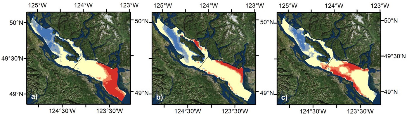
Chl-a hot spots (red) and cold spots (blue) in the Strait of Georgia, for (a) spring, (b) summer, and (c) autumn, calculated using climatological Chl-a concentrations. Yellow indicates non-significant pixels; dark vs. light red and blue colours refer to the 99 and 95% confidence intervals, respectively.
Several papers dealing with remote sensing of plastic marine litter have recently been published. Plastic litter is a form of marine debris that presents one of the ‘wicked environmental problems’ threatening the health of the world oceans. At present, with the ubiquitous spread of plastic pollution, information on its quantitative abundance, geographical distribution and environmental impacts is limited to opportunistic reports and scarce scientific observations, leaving large geospatial gaps that could be filled by remote sensing if the current and future satellites would be able to “see” marine debris. A growing number of studies address fundamental questions on feasibility of various remote sensing technologies to monitor marine litter. The discussion, started by Garaba and Dierssen (2018), Garaba et al. (2018), Goddijn-Murphy and Williamson(2019), Garaba and Dierssen (2020) and Topouzelis et al. (2019), was recently developed by Martinez-Vicente et al. (2019) into an initial assessment of the requirements for a satellite mission, discussed by marine plastic debris and remote sensing experts during the first workshop on Remote Sensing for Marine Litter, organized at ESTEC-ESA, The Netherlands, in 2017.
In the OceanObs’19 Community White Paper (Maximenko et al., 2019), a team of 62 international experts proposed a roadmap for construction of an Integrated Marine Debris Observing System (IMDOS), in which state-of-the-art remote sensing plays a critical role. In synergy with in situ observations and full-complexity dynamical models, IMDOS will reveal the pathways, distribution patterns, accumulation zones and fate of marine debris. IMDOS will generate essential descriptors, demanded by the diverse community of stakeholders. In the future, remote sensing technology will need to be developed that can be deployed on space satellite missions, High-Altitude Pseudo-Satellites, unmanned aerial systems, fixed observatories, ships-of-opportunity and to portable autonomous systems, with additional smartphone applications developed to be deployed by citizens.

Lastly, in another new paper, Mikelsons et al. (2020) developed a statistical approach to evaluate the performance of the ocean color (OC) data processing system for satellite-derived OC data products based on temporal stability of retrievals. Using the Multi-Sensor Level-1 to Level-2 (MSL12) OC data processing system to obtain the normalized water-leaving reflectance ρwN(λ) spectra from VIIRS measurements, the deviations of ρwN(λ) spectra from temporally and spatially averaged values were investigated, and the statistics with respect to various retrieval parameters were collected, including the solar-sensor geometry (solar-zenith, sensor-zenith, and relative azimuth angles), and various ancillary data (surface wind speed, surface atmospheric pressure, water vapor amount, and ozone concentration). The performance of MSL12 was also evaluated with respect to other intermediate retrieval parameters. The study shows that MSL12 produces statistically consistent VIIRS OC retrievals in the global open ocean, with respect to retrieval geometry parameters, as well as the ancillary inputs.
Employment Opportunities
Many new positions have been added to Employment Opportunities on the IOCCG website including several positions for research fellows/scientists at the University of Stirling (UK), the University of Toulon (France), NASA Ames Research (USA) and Khalifa University (United Arab Emirates), as well as post-doc positions at the University of São Paulo (Brazil), University of South Florida (USA), Khalifa University (UAE), and University of British Columbia/University of Victoria (Canada). In addition, scientific programmer/analyst positions are available at the LOG laboratory (Wimereux, France) and NASA GSFC (USA). For more information on these, and other positions see http://ioccg.org/resources/employment-opportunities/.
