IOCCG News
 IOCCG Publications
The Proceedings of the 2019 International Ocean Colour Science Meeting (9-12 April 2019, Busan, South Korea), including recommendations from the nine breakout sessions as well as abstracts from keynote speakers and agency presentations, are now available on the IOCS-2019 meeting website at: https://iocs.ioccg.org/wp-content/uploads/2019/06/proceedings-iocs-2019-meeting.pdf. The final minutes of the IOCCG-24 Committee meeting (4-6 April, Hanoi, Vietnam) are also available on the IOCCG website at: http://ioccg.org/wp-content/uploads/2019/05/minutes-ioccg-24-final.pdf.
Training Course in China
 After reviewing a large number of applications from 17 different countries, a total of 22 students have been selected to participate in the advanced training course on ocean colour remote sensing, scheduled to take place in Hangzhou, China from 24-31 October 2019. The workshop is organized and sponsored by the IOCCG, the EC Copernicus Programme, EUMETSAT, the State Key Laboratory of Satellite Ocean Environment Dynamics (SOED/SIO/MNR, China), the National Satellite Ocean Application Service (NSOAS, China), and Zhejiang University (ZJU, China). The key objective of this training is to help early career scientists to download, analyze and visualize data from the EUMETSAT Copernicus Marine Data Stream as well as the Chinese HY-1C ocean colour mission. Participants will also learn how to use the Marine Satellite Data Online Analysis Platform (SatCO2) for environmental monitoring and scientific research, including water quality monitoring, red tide detection, and marine carbon cycling/climate change investigations.
News from NOAA
New version of CoastWatch Central Data Portal
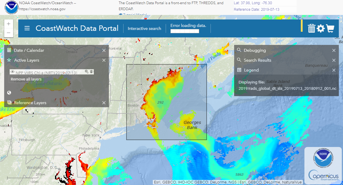
Screenshot of updated NOAA CoastWatch Data Portal
The NOAA CoastWatch/OceanWatch/PolarWatch Program (a.k.a., CoastWatch) released a new version of the CoastWatch Central Data Portal for viewing and accessing ocean satellite and ancillary data products (see image on right for screen shot of updated NOAA CoastWatch Data Portal). This update features expanded functions, including data sub-setting and the convenient “data cart” for batch downloading. Subscribe to the NOAA CoastWatch e-mail list to keep up with news from NOAA CoastWatch.
VIIRS Ocean Color May 2018 Cruise Report published at NOAA Library
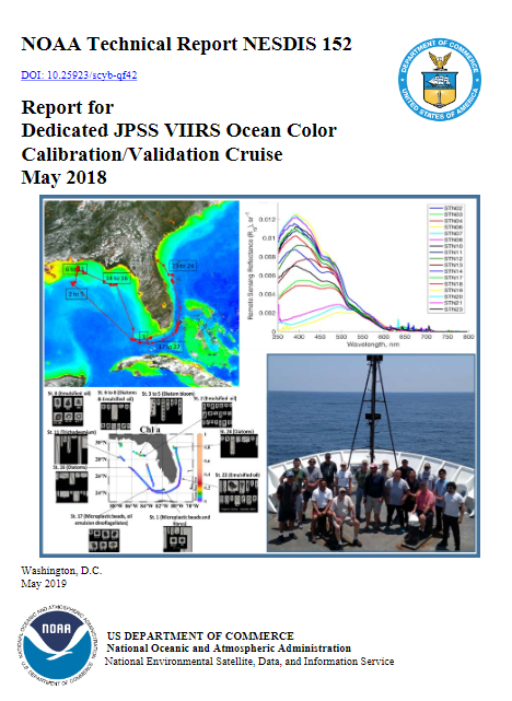 The NESDIS Technical Report for the 4th annual Joint Polar Satellite System Visible Infrared Imaging Radiometer Suite (JPSS VIIRS) dedicated ocean color calibration/validation cruise is now available in the NOAA Library. The 2018 field campaign aboard the NOAA Ship Okeanos Explorer (OMAO cruise identification #EX-18-04), May 9-18 2018, departed from Key West and disembarked in Jacksonville, FL. Twenty-four stations were sampled during the cruise, encompassing various water types from oligotrophic (very clear) to near-shore waters in the Gulf of Mexico, the Florida Straits, and the coastal Atlantic. Despite cloud-cover over most of Florida’s coasts, strategic planning utilizing weather forecasts enabled satellite validation matchups with VIIRS overpasses at 75% of the stations. Nine research groups participated in the cruise. In addition to shipboard measurements, pre- and post-cruise optical instrument calibration occurred at the NOAA/STAR optical laboratory in College Park, MD. Ongoing collaboration with National Institute of Standards and Technology (NIST) enhances the optical laboratory’s validation of the NOAA/STAR radiometric scales in support of cruise activities, and to provide traceable calibration services. You can access the report here: https://repository.library.noaa.gov/view/noaa/20267
News from NOAA and EUMETSAT
First International Operational Satellite Oceanography Symposium
The First International Operational Satellite Oceanography (OSO) Symposium, which was organized and sponsored by NOAA and EUMETSAT, was held June 18-20, 2019 at the NOAA Center for Weather and Climate Prediction Center in College Park, Maryland, USA (Brown et al., 2019). As the name implies, the purpose of the symposium was to bring together the international community of operational satellite oceanographic data and product providers and users for the first time in order to better define and understand the barriers, either perceived or actual, hindering the use of satellite oceanographic observations and facilitate their widespread incorporation into the value chain from data to useful information across the range of operational applications.
By all accounts, the symposium was a success and marked the beginning of a biennial tradition where those involved at all levels of the value chain, from data providers to users, would assemble in an effort to foster the use of operational satellite oceanographic data, products, applications and services in order to provide greater societal benefits. The next OSO Symposium will convene near Frankfurt, Germany during the late spring to early Summer of 2021.
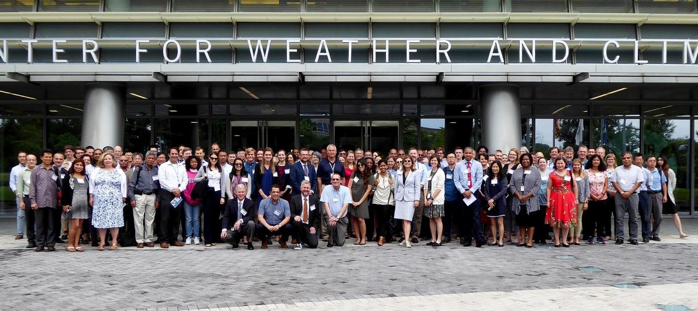
Participants at the First International Operational Satellite Oceanography Symposium held June 18-20, 2019 at the NOAA Center for Weather and Climate Prediction Center in College Park, Maryland, USA. Courtesy of Lori Brown, NOAA/NESDIS/Center for Satellite Applications & Research.
References: Brown, C. W., V. Lance, and F. Montagner (2019), Satellite oceanography data producers and users connect, Eos, 100, https://doi.org/10.1029/2019EO131295. Published on 20 August 2019.
News from NOAA and EUMETSAT
First International Operational Satellite Oceanography Symposium
The First International Operational Satellite Oceanography (OSO) Symposium, which was organized and sponsored by NOAA and EUMETSAT, was held June 18-20, 2019 at the NOAA Center for Weather and Climate Prediction Center in College Park, Maryland, USA (Brown et al., 2019). As the name implies, the purpose of the symposium was to bring together the international community of operational satellite oceanographic data and product providers and users for the first time in order to better define and understand the barriers, either perceived or actual, hindering the use of satellite oceanographic observations and facilitate their widespread incorporation into the value chain from data to useful information across the range of operational applications.
By all accounts, the symposium was a success and marked the beginning of a biennial tradition where those involved at all levels of the value chain, from data providers to users, would assemble in an effort to foster the use of operational satellite oceanographic data, products, applications and services in order to provide greater societal benefits. The next OSO Symposium will convene near Frankfurt, Germany during the late spring to early Summer of 2021.
Participants at the First International Operational Satellite Oceanography Symposium held June 18-20, 2019 at the NOAA Center for Weather and Climate Prediction Center in College Park, Maryland, USA. Courtesy of Lori Brown, NOAA/NESDIS/Center for Satellite Applications & Research.
References:
Brown, C. W., V. Lance, and F. Montagner (2019), Satellite oceanography data producers and users connect, Eos, 100, https://doi.org/10.1029/2019EO131295. Published on 20 August 2019.
Applications open for ESA Advanced Ocean Synergy Training Course 2019
 The European Space Agency (ESA), in cooperation with the Technical University of Crete, is organising an Advanced Ocean Synergy Training Course devoted to training the next generation of Earth Observation scientists to exploit data from ESA and Third Party Mission instruments for ocean science and application development.
The course will be held at the Venetian Arsenali building at the Center of Mediterranean Architecture, Chania, in Crete (Greece) from 04 to 08 November 2019. The deadline for applications is: 1 September 2019. Using a series of lectures and laboratory classes, group-work and discussion, the aim of the course is to develop new skills in the application of complementary satellite ocean remote sensing data sets and their application in synergy for science and applications serving society. The course will include:
- The theoretical principles and application of Synthetic Aperture Radar, Radar Altimetry, Ocean Colour Radiometry, Infrared and Passive Microwave Radiometry, for physical and biogeochemical ocean parameters retrievals
- Hands-on exercises using SAR, Optical, Infrared, Passive Microwave, and Altimeter data, tools/toolboxes and methods for the exploitation of EO satellite data in synergy over the ocean
- Stimulating and supporting the exploitation of the ESA Earth Explorer and Copernicus Sentinel Missions
More information can be found here: http://oceantrainingcourse2019.esa.int/
WASI (Water Colour Simulator): Version 5 Now Available
The Water Color Simulator WASI is a software tool for the simulation and analysis of the most common types of spectral measurements in open waters under outdoor conditions. The 2D mode allows the processing of atmospherically corrected multispectral and hyperspectral data. WASI was developed especially for the analysis of regional data and can be adapted by the user to different sensors and optical properties of the study area. A lot of effort has been put into making the user interface as clear and flexible as possible. You can download the zip file (69 MB) from the IOCCG website, or download the installation file directly here.
Ocean Optics 2019 Summer Class
Another successful NASA-sponsored Ocean Optics class took place in June 2019 at the University of Maine’s Darling Marine Center. Twenty students with diverse backgrounds and origins took place in this four week Optics ‘bootcamp’.
Lectures, labs and other relevant materials (including PowerPoint presentations, videos and code) can be accessed at: http://misclab.umeoce.maine.edu/OceanOpticsClass2019/schedule/
Ocean Colour-Related Meetings
![]() The OceanObs’19 Conference (16-21 September, 2019, Hawaii) will be the third conference of this series, held once every ten years. OceanObs’19 will strive to improve the governance of a global ocean observing system. Eight community-led breakout sessions are scheduled to run parallel on each day of the conference aiming to generate feedback on the conference themes and goals. There will also be several organizational and community-led special sessions focusing on a variety of unique ocean observing topics.
The OceanObs’19 Conference (16-21 September, 2019, Hawaii) will be the third conference of this series, held once every ten years. OceanObs’19 will strive to improve the governance of a global ocean observing system. Eight community-led breakout sessions are scheduled to run parallel on each day of the conference aiming to generate feedback on the conference themes and goals. There will also be several organizational and community-led special sessions focusing on a variety of unique ocean observing topics.
![]() The AGU Fall Meeting will take place from 9 – 13 December 2019 in San Francisco, USA. Cara Wilson (IOCCG Chair) will be hosting an IOCCG Town Hall and will present the current and developing activities of the IOCCG and encourage the involvement of the Ocean Sciences community in IOCCG activities. Several ocean-colour related sessions will be held at AGU, including:
The AGU Fall Meeting will take place from 9 – 13 December 2019 in San Francisco, USA. Cara Wilson (IOCCG Chair) will be hosting an IOCCG Town Hall and will present the current and developing activities of the IOCCG and encourage the involvement of the Ocean Sciences community in IOCCG activities. Several ocean-colour related sessions will be held at AGU, including:
- OS023: Oceanography from Space: Applications for Satellite-based Ocean Observations
- A004: Advances in Atmospheric Remote Sensing Techniques and Theories
- A017: Advances of Atmospheric Remote Sensing Inversion
 The 2020 Ocean Sciences Meeting will take place from 16-21 February 2020 in San Diego, California. Abstract and town hall submissions are now open (closing on 11th and 18th September 2019, respectively). Consider submitting an abstract to one of the ocean-colour related sessions, several of which are highlighted below:
- CP013: Regional to Global Monitoring of Coral Reef Ecosystems
- CP019: Water quality monitoring and forecasting in coastal and inland waters: Applications and operational services
- HE002: Biogeochemical Fluxes and Ecological Processes in the Rapidly Changing Coastal Arctic
- IS001: Active optics to sense marine productivity throughout the world’s coasts and oceans
- IS007: From catchments to open ocean: advances in remote sensing for monitoring water quality, food security, ecosystems and change.
- ISO13: Operational Satellite Oceanography
- ME009: Hyperspectral Sensing of Coastal Aquatic Environments
- ME015: Using satellite remote sensing and in situ data to evaluate marine biodiversity and ecosystems
- OB011: From the twilight zone to the troposphere: ocean optics applications to biogeochemical cycling in and through the surface ocean
- OB024: Quantifying Carbon Export Pathways in the Global Ocean
- OD009: New information systems tools for implementing autonomous multi-source, multi-point observing systems
New Publications
A new publication by Vansteenwegen et al. (2019) has been added to the IOCCG Ocean Colour Bibliography. This paper describes a system, named “pan-and-tilt hyperspectral radiometer system (PANTHYR)” that has been designed for autonomous measurement of hyperspectral water reflectance. The system is suitable for deployment in diverse locations, including remote offshore platforms, for the validation of water reflectance derived from any satellite mission with visible and/or near infrared spectral bands (400 – 900 nm). PANTHYR consists of two hyperspectral radiometers, mounted on a pan-and-tilt pointing system, controlled by a single-board-computer and associated custom-designed electronics which provide power, pointing instructions and data archiving and transmission. In this paper the system design is summarised and a prototype test on the Acqua Alta Oceanographic Tower is described, including comparison of the PANTHYR system data with two other established systems: the multispectral autonomous AERONET-OC data and a manually-deployed 3-sensor hyperspectral system.
The test established that high-quality hyperspectral data for water reflectance can be acquired autonomously with this system.
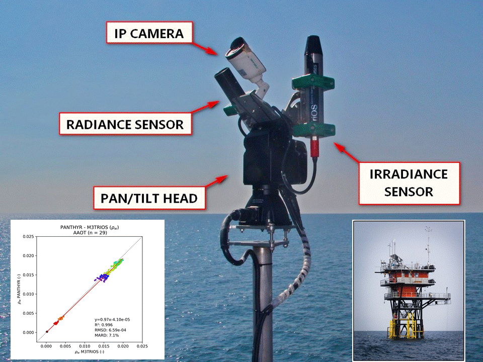
Photograph of PANTHYR prototype deployment at Acqua Alta Oceanographic Tower (AAOT): Irradiance and sky radiance measurement position (from Vansteenwegen et al. 2019, Remote Sens. 11(11), 1360.)
Various forms of floating algae are found in the global oceans. In another new publication in the journal Science, Wang et al. (2019) use MODIS observations to discover a recurrent Sargassum belt, which extends from west Africa to the Caribbean and Gulf of Mexico every summer since 2011 (except 2013). The great Atlantic Sargassum belt (GASB) reached >8000 km long in July 2018, containing at least 20 million metric tons of Sargassum. While the shape of the belt is primarily driven by ocean circulations, recent increases of Sargassum abundance are thought to be a result of nutrient enrichment from several sources, both natural and anthropogenic. Because Sargassum can be both a habitat in the ocean and a nuisance on the beach, and because recurrent Sargassum blooms are thought to be a new normal in the near future, the study calls for more research to understand this marine plant, including its impact on carbon/nutrient cycling and fishery, and to find better mitigation strategies and utilization techniques.

The great Atlantic Sargassum belt (GASB) in July 2018. The color shows mean Sargassum areal density. Figure from Wang et al. (2019).
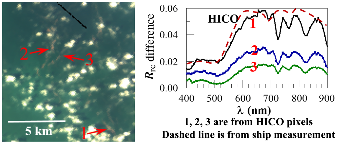
HICO image on 9 September 2013 showing reddish slicks (marked as “1”, “2”, “3”), with their spectral shapes nearly identical to spectra measured from an RNS bloom off Belgium. Figure from Qi et al. (2019).
In another study of floating algae, Qi et al. (2019), used multiple sensors to detect red Noctiluca scintillans (RNS) blooms in the East China Sea, a marginal ocean in the western Pacific. RNS is a heterotrophic dinoflagellate that feeds on other small algae and zooplankton. It can produce blue bioluminescence at night (often called “blue tears” in southeast Asia), attracting tourists, but blooms of RNS represent one form of red tides. RNS has specific absorption and scattering properties, resulting in unique spectral shapes that can be captured by the hyperspectral HICO and many multi-spectral sensors. The 2000 – 2017 series of images show increasing RNS blooms in recent years, possible from coastal eutrophication. The proof-of-concept study is expected to serve as a template to study RNS blooms elsewhere.
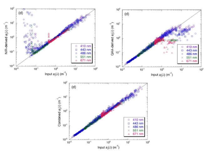
Comparison of the NIR-QAA combined IOP retrievals with Hydrolight inputs (true values) at VIIRS spectral bands for total absorption (at(λ)). From Shi and Wang (2019).
Ocean Color EDR team member Wei Shi and Ocean Color EDR Lead Menghua Wang have authored a peer-reviewed manuscript entitled “A blended inherent optical property algorithm for global satellite ocean color observations”, published in the journal Limnology and Oceanography: Methods. Water inherent optical properties (IOPs) can be derived from satellite-measured normalized water-leaving radiance (nLw(λ)) spectra. The authors evaluated the performance of the quasi-analytical algorithm (QAA) and the near infrared (NIR)-based IOP algorithm using a Hydrolight simulation data set covering a wide range of water types that span from clear open ocean to turbid coastal/inland waters. The NIR-based algorithm produces significantly improved IOP retrievals over turbid coastal and inland waters, while the QAA algorithm performs well in the open ocean and less turbid coastal waters. Based on the advantages of the NIR-based and QAA-based algorithms, a combination of the NIR and QAA-based algorithm has been proposed using satellite-measured nLw(745) as the threshold in order to produce accurate IOP products for both the open ocean and turbid coastal/inland waters. The new combined IOP algorithm can produce reasonably accurate IOP data for all water types and can be easily implemented into the satellite ocean color data processing. The La Plata River Estuary region was used as an example to show the difference in performance of IOP retrievals from the Visible Infrared Imaging Radiometer Suite (VIIRS) measurements between 2012 and 2017 with the NIR-based, QAA-based, and NIR-QAA combined IOP algorithms. They also demonstrated the NIR-QAA combined algorithm can be applied to VIIRS global ocean color observations to derive good quality IOP products in China’s east coastal region, the US east coastal region, and the region of the Mississippi River estuary and tributaries.
Lastly, eight manuscripts addressing several key aspects of NASA’s upcoming PACE mission, spanning from whitecaps through atmospheric correction to advanced aerosol and cloud retrievals, have been published in a special issue of Frontiers edited by David Antoine and Oleg Dubovik. These articles can be accessed at: https://www.frontiersin.org/research-topics/7637/from-the-satellite-to-the-earths-surface-studies-relevant-to-nasas-plankton-aerosol-cloud-ocean-ecos#articles
Employment Opportunities
Several new positions have been added to Employment Opportunities on the IOCCG website including a Postdoctoral Fellow in Ocean Optics and Particle Dynamics (University of Southern Mississippi, USA), a Research Assistant position at the Marine Bio-Optics, Remote Sensing and Satellite Research Group (Curtin University, Western Australia), PACE Applications Coordinator position at NASA GSFC (USA), a software engineer to support the Ocean Biology Distributed Active Archive Center at NASA/GSFC (USA), and two positions (Optical Instrumentation Engineer and Scientific Computing Engineer) for the BOUSSOLE Project (France). See Employment Opportunities on the IOCCG website for information on these, and other positions.
