IOCCG news bulletins include items of interest from the IOCCG, its sponsoring agencies, as well as the broader ocean colour community (including new publications). Please let us know if there are any other items of interest you would like to see included in the next IOCCG news bulletin (contact Raisha Lovindeer, with a cc: to Venetia Stuart). You can also follow IOCCG on Twitter.
IOCCG News
26th IOCCG Committee Meeting
The 26th IOCCG Committee Meeting was held in hybrid format from 27 – 29 June 2022, hosted by the European Space Agency (ESA) in Frascati Italy. The meeting was attended in-person and virtually by Scientific Committee members as well as representatives from space agencies across the globe. The members were updated on the activities of the two active IOCCG Scientific Working Groups on Atmospheric Correction and on Benthic Reflectance, as well as a close-out report of the working group on the synergy between ocean colour and biogeochemical and ecosystem models, which resulted in Report 19: Synergy between Ocean Colour and Biogeochemical/ Ecosystem Models. Members were also updated on the continued work of the two active IOCCG task forces on Ocean Colour Satellite Sensor Calibration and Remote Sensing of Marine Litter and Debris, and discussions took place on the proposed task force on ocean colour system vicarious calibration (OC-SVC), revising the “Ocean Carbon from Space” task force, and facilitating a round-robin with hyperspectral datasets.
Other interesting discussions focussed on the need for higher quantitative data at 1-km spatial resolution over coastal waters (new coastal driven processing), the generation of water-quality operational products from very high resolution data (e.g., Sentinel-2A/B and Landsat 8/9), establishing an international database of match-up data points, and seasonal biases in ocean colour.
Plans for the next International Ocean Colour Science meeting were also reviewed, and the meeting is tentatively scheduled for 13-17 November 2023, to be hosted by the University of South Florida, in St. Petersburg, USA. The final minutes of the meeting are available on the IOCCG website at https://ioccg.org/what-we-do/committee-meetings/.
New IOCCG Chair and Committee Members
 One of the requirements of being an Affiliated Program of SCOR is the regular rotation of IOCCG Committee members. Bryan Franz (NASA GSFC) officially rotated off the Committee and was replaced by Jeremy Werdell (NASA GSFC). Bryan was thanked for his valuable contributions over the past few years, and Jeremy was warmly welcomed onto the Committee. We also warmly welcome Mark Baird (CSIRO, Australia), who accepted his nomination to join the IOCCG Committee for his expertise in using ocean colour in ecosystem modelling, and look forward to working with him over the course of his term.
At the end of the IOCCG-26 meeting the IOCCG Chair was also officially handed over from Cara Wilson (NOAA/NMFS, USA) to Shubha Sathyendranath (PML, UK). Cara was thanked for her hard work and dedication in guiding the IOCCG Committee over the past five years, and Shubha was warmly welcomed onto the Committee. We all look forward to working with her over the next few years.
5th IOCCG Summer Lecture Series
The 2022 IOCCG Summer Lecture Series was was recently hosted by the Institut de la Mer de Villefranche (IMEV) in Villefranche-sur-Mer, France (18 – 29 July 2022) and was supported by contributions from CNES, Copernicus Program, IMEV, LOV, EUMETSAT, IOCCG, OCB Program (USA), RBINS and Sea-Bird Scientific (for providing an AC-S Spectral Absorption and Attenuation Sensor for the practical sessions).
The two-week advanced training course was attended by 23 students from 14 different countries (out of a total of 145 applicants) along with 11 passionate and dedicated lecturers who delivered a wide range of lectures on the fundamentals of ocean optics and atmospheric correction as well as various applications and hands-on practical lab sessions. Group discussion sessions facilitated interaction between the students and lecturers, both on topics from the lecture series, as well as their own scientific research. Judging by the feedback from the students, the training course was a huge success with students saying that it was one of the most exciting experiences ever, with great instructors and friendly students! Thank you to all the energetic lecturers who volunteered their time to teach at this event. The lecture slides and video recordings of all the lectures will soon be posted on the IOCCG website at: https://ioccg.org/what-we-do/training-and-education/lectures/. This is an excellent resource on a range of ocean-colour related topics.
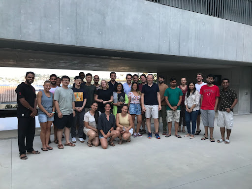
Students and lecturers at the 2022 Summer Lecture Series in Villefranche-sur-Mer, France.
Inaugural IOCCG Trevor Platt Memorial Scholarship
The IOCCG has opened applications to the inaugural award of the Trevor Platt Memorial Scholarship for ocean colour research and training, in honour of the late Professor Trevor Platt. Among many other accomplishments, Trevor was a founding member of the IOCCG and first Chairman of the group from 1996 to 2006. The Scholarship aims to provide students and early career scientists from developing countries or economies in transition with the opportunity to gain valuable experience in ocean colour remote sensing and applications. Graduate students and early career scientists (within 5 years from a PhD) from any of these eligible countries are encouraged to apply. Two scholarships will be issued for the inaugural award. Read the full announcement on our website: https://ioccg.org/what-we-do/training-and-education/platt-scholarship. Applications close on 11 November 2022.
News from NASA
3rd Annual PACE Applications Workshop
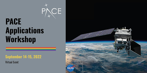 The NASA Plankton, Aerosol, Cloud, ocean Ecosystem (PACE) Mission invites you to join the 3rd annual PACE Applications Workshop, being held virtually from 14 – 15 September, 2022. The event will focus on advancing the application readiness and societal value of future PACE satellite data, research, and applications. The workshop group will collectively identify next steps to address barriers and gaps to ensure PACE data accessibility, usability, and actionability. Click here to register for the workshop, or contact the PACE Applications team if you have questions.
1st GLIMR Applications Workshop
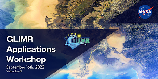 Registration is now open for the 1st NASA GLIMR Applications Workshop to be held online on September 16, 2022, from 12:00 to 4:00 pm ET. NASA’s GLIMR mission will launch a geostationary sensor that will provide actionable data for a dynamic coastal ocean. This event will introduce the GLIMR mission and will discuss how measurements from the vantage point of geostationary orbit offer an unprecedented potential to benefit society, inform stakeholders, and support decision-making in the context of coastal hazards, disasters, resource management, human health, food security, climate change, and ecological forecasting. Register for the event here and join the conversation on social media with #GLIMRApps2022
Materials available for PACE Training Course 2022: What’s behind the curtain of the PACE mission?
A one-week graduate-level course for students and early career researchers was held from August 1-5, 2022 at the University of Maryland Baltimore County (UMBC) and NASA Goddard Space Flight Center (GSFC) on the upcoming NASA PACE mission as well as on ocean and atmosphere passive satellite remote sensing. 42 participants attended, including atmospheric scientists and oceanographers from institutions in the United States, Uganda, Ireland, Canada, Uruguay, and Australia. The course was supported by the Ocean Carbon and Biogeochemistry (OCB) Program, and included lectures, labs, and field trips to NASA GSFC to see the PACE observatory and instruments facilities and to meet PACE Project systems engineers, as well as to the AERONET atmospheric science site on-location at UMBC.
More information about the course, as well as lecture slides and recordings will be made freely available to the public on this OCB webpage for the training activity.
News from EUMETSAT
Fiducial Reference Measurements for Satellite Ocean Colour Phase 2 Project Workshop
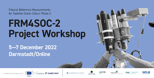 The Fiducial Reference Measurements for Satellite Ocean Colour (FRM4SOC) Phase 2 Project Workshop will be held from 5 – 7 December 2022 in Darmstadt, Germany, and online. The goal of the workshop is to discuss procedures, guidelines and tools developed for in situ ocean colour radiometers of the type of TriOS RAMSES and SeaBird HyperOCR, and for their measurements. The workshop will cover radiometer calibration and characterisation results and guidelines for users as well as for calibration laboratories. The measurement procedures will be presented, which are prescriptive and include radiometer-specific steps. A complete uncertainty budget for radiometers and their measurement will be described. The community processor for the radiometric measurements and the complete uncertainty budget calculation will be demonstrated and discussed. The results of testing of the procedures, guidelines and tools during the field exercise at the Acqua Alta Oceanographic Tower will also be described. The workshop will further seek community feedback on steps towards FRM compliance and FRM certification of ocean colour radiometric measurements. Register here by 20 November 2022.
News from CNES
Gathering user needs for infrared high resolution observations
 The TRISHNA mission (Thermal infraRed Imaging Satellite for High-resolution Natural resource Assessment) is a cooperation between the French (CNES) and Indian (ISRO) space agencies. It will measure the optical and thermal spectra emitted and reflected by the Earth from a low-altitude Sun synchronous orbit, over a swath with a width of 1026 km. It is intended to measure approximately twice a week the thermal infrared signal of the surface-atmosphere system at 57 m resolution for the continents and the coastal ocean. The spectral domain covers 11 bands from visible to thermal infrared, which are distributed over two instruments: the VNIR/SWIR Indian instrument and the TIR French instrument. The 4 thermal infrared bands of the TIR instrument are used for emissivity and surface temperature retrieval. The targeted launch date for TRISHNA satellite is 2025, being then positioned as a precursor of the ESA High Priority Copernicus Land Surface Temperature Monitoring (LSTM) mission foreseen in 2028.
A questionnaire set up by IFREMER aims at refining the coverage mask for the full resolution (60m) acquisition mode of TRISHNA, both spatially (areas with 60 m resolution acquisitions) or temporally (subsampling in high latitude regions). You are welcome to indicate your needs by filling this online questionnaire.
Upcoming Events
Xiamen Symposium on Marine Environmental Sciences (XMAS)
The sixth Xiamen Symposium on Marine Environmental Sciences (XMAS-VI) will be held in Xiamen from 9 – 12 January, 2023. XMAS-VI will focus on Multidisciplinary and Solution Sciences for a Sustainable and Healthy Ocean. Abstract submission is now open with a deadline of September 30, 2022, 17:00 (China Standard Time). Sessions relevant to the ocean colour community include:
- BIO-05\INT-06 Primary production estimation: Remote sensing of oceanic primary production
- BIO-01 Harmful Algal Blooms: Harmful algal blooms under changing climate: mechanisms, monitoring, and mitigation for a sustainable, safe and healthy ocean
- BIO-07\INT-08 DS4MES: Data Science for Marine Ecosystem Studies
Ocean Optics XXV
Registration continues for Ocean Optics XXV, which will take place from 2 – 7 October, 2022 in Quy Nhon, Binh Dinh, Vietnam, at the International Centre for Interdisciplinary Science and Education (ICISE). Several half-day short courses are planned for 2 October at no additional cost. These include topics that relate to Copernicus software, HydroLight software, and more. See the website for additional details. For questions, contact Jenny Ramarui.
Publication Highlights
Particulate inorganic carbon (PIC) plays a major role in the ocean carbon cycle impacting pH, dissolved inorganic carbon, and alkalinity, as well as particulate organic carbon (POC) export and transfer efficiency to the deep sea. Remote sensing retrievals of PIC in surface waters span two decades, yet knowledge of PIC concentration variability in the water column is temporally and spatially limited due to a reliance on ship sampling. To overcome the space–time gap in observations, Bishop et al. (2022) developed optical sensors for PIC concentration and flux that exploit the high mineral birefringence of CaCO3 minerals, and thus enable real-time data when deployed operationally from ship CTDs and ARGO-style Carbon Flux Explorer floats. For PIC concentrations, the authors describe a fast (10 Hz), digital, low-power (∼0.5 W) sensor that utilizes cross-polarized transmitted light to detect the photon yield from suspended birefringent particles in the water column. This sensor has been CTD-deployed to depths as great as 6,000 m and cross-calibrated against particulates sampled by large volume in situ filtration and CTD/rosettes. The authors report data from the September–November 2018 GEOTRACES GP15 meridional transect from the Aleutian Islands to Tahiti, which includes many nearly particle-free waters, as well as results from the June 2017 California Current Ecosystem-Long Term Ecological Research (CCE-LTER) process study in California coastal waters, where high PIC levels were found. The authors demonstrate that sensor can detect PIC concentration variability from 0.01 to >1 μM in the water column (except in nepheloid layers) and outline engineering needs and progress on its integration with the Carbon Flux Explorer —an autonomous float.
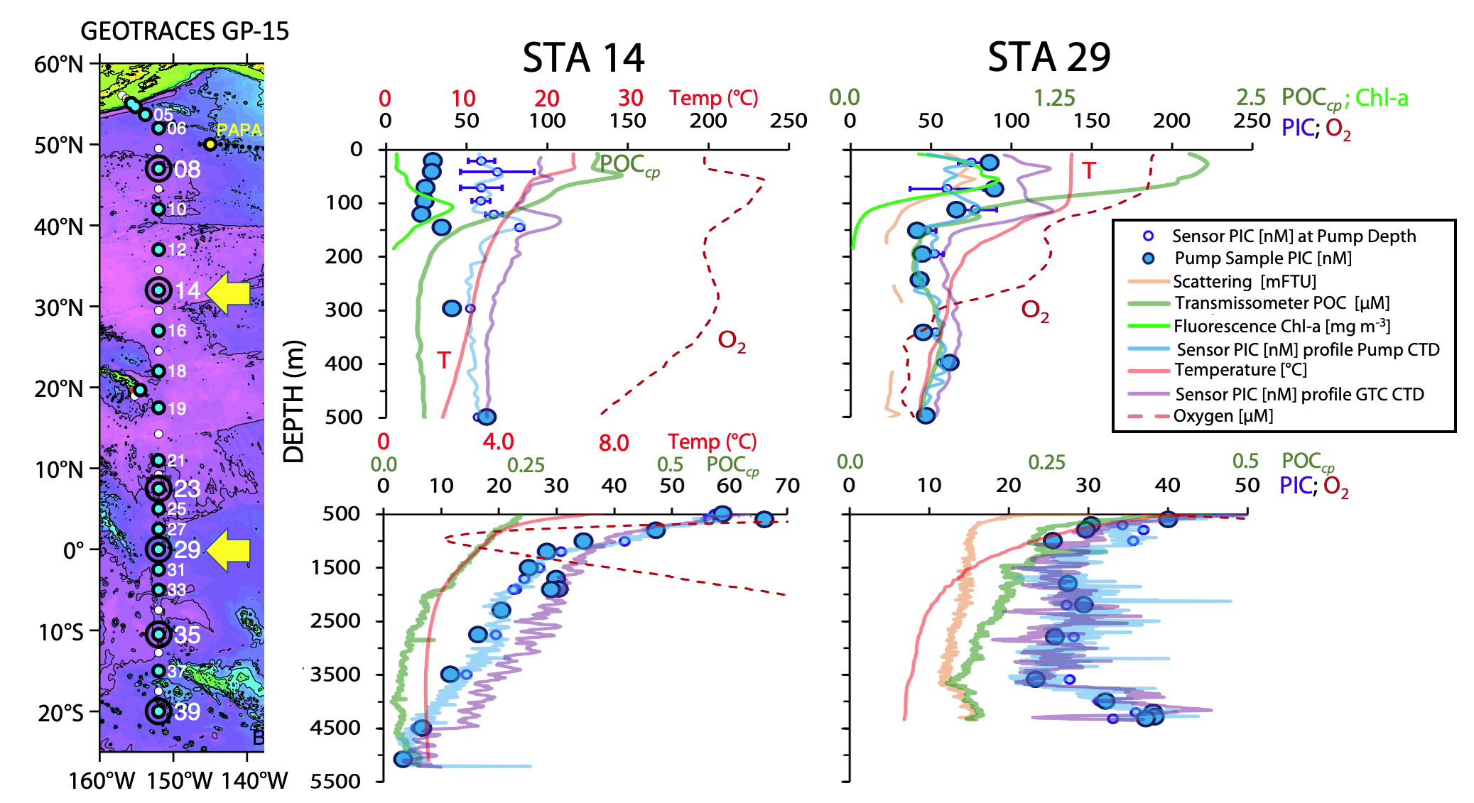
Map showing locations and bathymetric context for the depth profiling of two novel laser polarization sensors designed to detect concentrations of particulate inorganic carbon (PIC) during the 2018 GEOTRACES GP-15 transect. Yellow arrows indicate locations of stations 14 and 29 where profile data are shown to the right side of the map. Blue and purple lines depict PIC profiles from the two sensors. Large blue circles denote laboratory measured PIC concentrations from in-situ pump samples; small blue symbols denote sensor PIC at the same depth and time as sample collection. Also shown are chlorophyll fluorescence (bright green), scattering (light brown), particulate organic carbon (POC) calculated from beam attenuation coefficient. Redrawn from Figure 10c of Bishop et al. (2022).
Kolluru and Tiwari (2022) developed a new machine learning model to estimate Chlorophyll-a concentration from global ocean waters with four ocean color bands present in most existing ocean color sensors. The Multi-Layer Perceptron Neural Network (MLPNN) based on Resilient backpropagation method was trained on NASA’s NOMAD and tested on three validation datasets, namely, SeaWiFS and MODIS matchup datasets and a simulated dataset with measurements from the Red Sea. The proposed MLPNN showed promising results over traditional algorithms with blue and green bands over a wide range of chl-a concentration levels including oligotrophic and eutrophic waters. Hyperparameter tuning of the MLPNN and extensive tests with different types of input configuration (using only four bands) resulted in the best configuration to estimate chl-a. Implemented the MLPNN on satellite data from SeaWiFS, MODIS, VIIRS, and SeaHAWK sensors indicated the ability of MLPNN to identify ocean color features in global open ocean, coastal waters and in phytoplankton blooms in Arabian Sea and the Red Sea. The MLPNN developed in the study has direct implications for the future multi- and hyperspectral sensors, such as PACE and OceanSat-3, to understand phytoplankton distribution, primary productivity, and other processes at regional and global scales.
In another new publication, Castagna et al. (2022) describe a freely accessible dataset of paired optical (absorption, scattering, reflectance, etc) and biogeochemical properties (phytoplankton pigments, metabarcoding, suspended matter, etc) for a diverse set of environments in Belgium: one lagoon, eight lakes, the Scheldt estuary, and the Belgian coastal zone. The data can be used for ecological research and development or evaluation of retrieval algorithms for in situ optics or remote sensing. The data is freely available through PANGAEA and LIMNADES repositories.
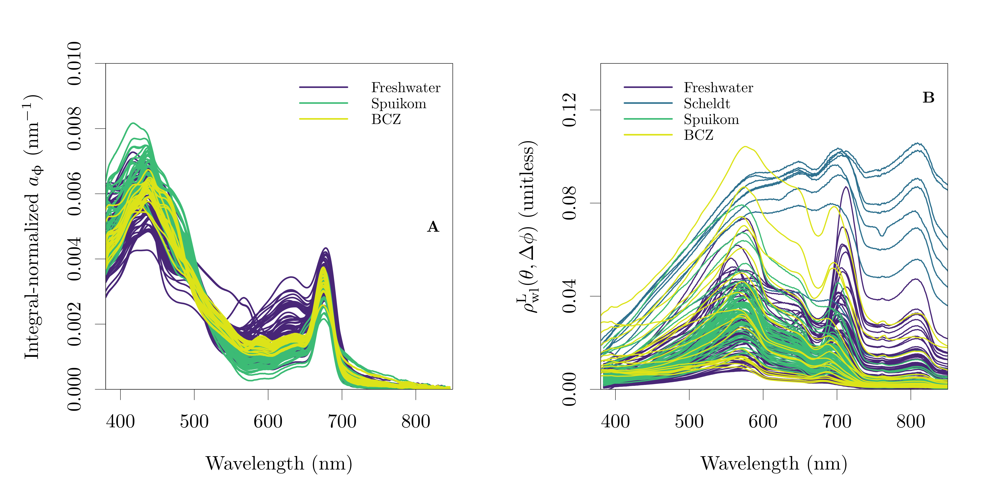
Spectral absorption and reflectance measured in Belgium systems between 2017 and 2019. (A) Integro-normalized in vivo pigment absorption coefficient (nm-1); (B) Lambert-equivalent water-leaving bi-hemispherical reflectance (unitless).
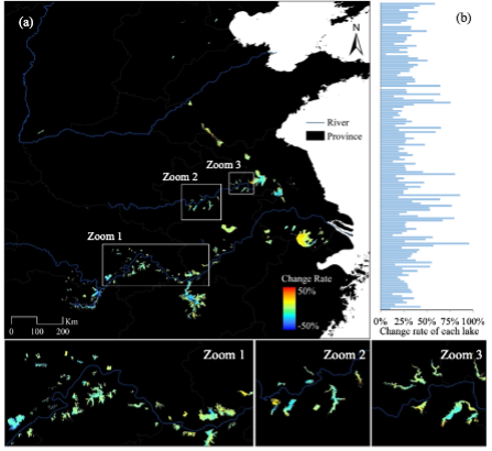
The relative change rate of trophic state index (TSI) in the eastern plain lakes of China from 1986 to 2020: (a) spatial distributions and (b) statistical results sorted by latitude.
Hu et al, 2022 published a paper monitoring the eutrophication of 146 small and medium-sized lakes in East China based on 35-year Landsat data, using a trophic state index (TSI). Previous study conducted trophic state assessment for large lakes and reservoirs worldwide using MODIS. However, small and medium lakes account for more than 70% of reservoirs and have not been thoroughly investigated. The authors developed a method to estimate TSI based on the algal biomass index, and further improved the retrieval precision by a pixel-wise water classification scheme using a turbid water index. The TSI of the East China lakes increased over the past 35 years by 8.2%, and four change patterns of inter-annual TSI variations were defined. The authors also explained how urbanization and nutrient inputs influenced rapid eutrophication and caused sudden increases in the TSI. They emphasized the effectiveness of using multi-sensor Landsat satellite observations to expand the time scale and spatial scope of water quality monitoring.
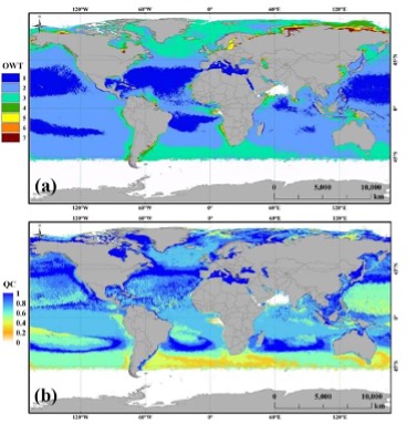
Global OWTs (a) and QC scores (b) from MODIS Level-3 monthly climatology data (July).
Qing et al., 2022 developed an optical water classification and quality control model (OC_QC model) based on a globally collected high-quality in situ Kd(λ) data. The model consists of the reference Kd(λ) spectra for 7 optical water types (OWT, ranging from clear open ocean water to highly turbid water) and a scoring system. An individual Kd(λ) spectrum can be assigned an OWT and quality control score (QC score) with this model. The performance of the OC_QC model is tested with independent in situ Kd(λ) spectra from the turbid coastal water (Bohai Sea) and clear oceanic water (Indian Ocean). Questionable or erroneous Kd(λ) spectra can be identified, suggesting the model’s robustness. The model was also evaluated with the Medium Resolution Imaging Spectrometer (MERIS) Level-2 and the Moderate Resolution Imaging Spectroradiometer (MODIS) Level-3 Kd(λ) data in the Bohai Sea, Yellow Sea, East China Sea and South China Sea. Satellite derived maps clearly showed the spatial and temporal variations of OWTs and QC scores, and the regions of low-quality Kd(λ) were reasonably extracted. Global maps of Kd(λ)-based optical water types and corresponding QC scores were also obtained with OC_QC model. With the quality controlled Kd(λ) data, the retrieval accuracy of Secchi disk depth was improved. The retrieval accuracies of Chlorophyll-a concentration and total seawater absorption coefficient were also improved with the Kd(λ) optical water classification based algorithms. The OC_QC model would be valuable for evaluating Kd(λ) data (especially the operational global Kd(λ) products), investigation of water optical properties, and development and merging of bio-optical algorithms.
Liu et al., 2022 propose a new red tide detection method based on pseudo hue angle (PHA-RI) for high spatial resolution broad band satellite data. Different from the standard International Commission on Illumination (CIE) system, the false-color bands of near infrared (NIR), red and green are used to calculate the CIE tristimulus X, Y, Z, instead of the true-color bands of red, green and blue. With this method, the red tide can be easily differentiated from non-red tide water, and the distinction between red tide and non-red tide water is doubled compared to that of true-color bands composite. Experiment results show that the PHA-RI method can effectively detect red tide, with an averaged overall accuracy, F1-score and precision of 92%, 0.92 and 0.92 respectively. Compared with traditional machine learning methods support vector machine (SVM) and spectral index algorithm Gaofen-1 (GF-1) red tide detection index (GF-RI), the proposed algorithm has obvious advantages in red tide detection, especially for the strip distributed red tide. Besides, the proposed algorithm has good applicability. It is proved to be applicable to different broad band sensors, such as Chinese satellites GF-1 Wide Field of View (WFV), Haiyang 1D (HY-1D) Coastal Zone Imager (CZI), Sentinel-2 MultiSpectral Instrument (MSI) and Landsat 8 Operational Land Imager (OLI). The application experiment indicates that the proposed algorithm is effective in red tide detection, and it can successfully detect fine-scale red tide events. The results also show the advantages of high spatial resolution satellites in fine-scale red tide detection.
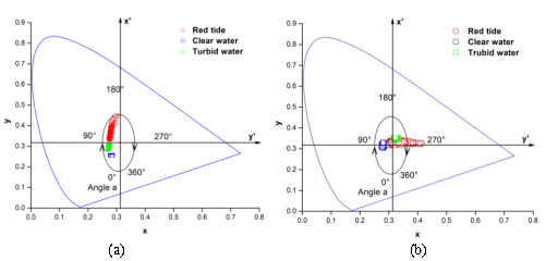
(a) CIE 1931 chromaticity diagram of the red tide, clear water, and turbid water calculated by NIR, red, and green bands; (b) CIE 1931 chromaticity diagram of red tide, clear water and turbid water calculated by red, green and blue bands.
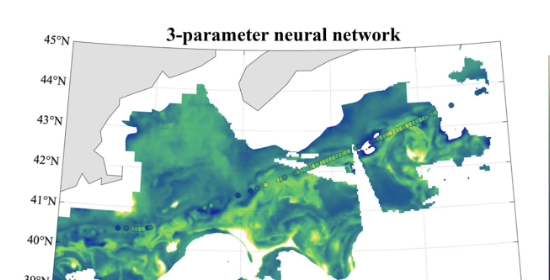
Diatom carbon concentrations in the western North Atlantic estimated using a shallow neural network trained with chlorophyll a, temperature, and salinity as the model inputs, and diatom carbon determined from cell imagery as the network target parameter. The overlain dots show the in situ estimates of diatom carbon from the imaging-in-flow cytometry data.
Chase et al (2022) highlight the added information gained from using imaging-in-flow cytometry data collected in situ, which provide images of individual phytoplankton cells. These data, following classification using a combination of manual and machine learning methods, allow for quantification of phytoplankton within several major taxonomic groups. Diatoms are the focus of the present study and the concentration of cell biovolume and carbon is calculated for data collected during four research cruises in the western North Atlantic during 2015-2018. Results show the large range of diatom carbon concentrations as a function of chlorophyll a concentration, as well as a discrepancy in diatom carbon as a function of chlorophyll a when diatom carbon is estimated from imagery vs. from pigment proxies, as has been done often in the past. The added information on the variability of diatom carbon across environmental conditions provided by the cell imagery data highlights the need for thoughtful determination of how target variables, namely phytoplankton groups, are defined during remote sensing algorithm development. To further emphasize this, a shallow neural network is trained using in situ environmental and cell imagery data and subsequently applied to satellite-based chlorophyll a, temperature, and salinity estimates. Results show spatial patterns in diatom carbon concentrations across the western North Atlantic that differ from patterns observed when diatoms are estimated via pigment proxies.
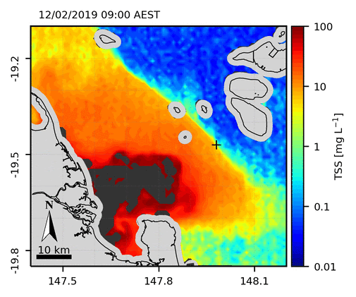
Diurnal variability of Total Suspended Solids over the Burdekin River mouth, Great Barrier Reef, Australia, in February 2019 from 10 min Himawari-8 observations.
And lastly, Patricio-Valerio et al. (2022) developed a model-based ocean colour inversion algorithm using artificial neural networks to retrieve diurnal Total Suspended Solids (TSS) concentrations in the coastal Great Barrier Reef (GBR) from geostationary Himawari-8 AHI observations. The machine learning algorithm developed in this work allows the direct inversion of AHI top-of-atmosphere reflectance data to derive a wide range of TSS concentrations (0.01 to 100 mg L−1) at a temporal resolution of up to 10 min. The retrieval accuracy of the inversion algorithm was determined by comparing the satellite estimated TSS with concurrent in-situ TSS measurements in the coastal GBR. Himawari-8 AHI signal-to-noise ratios and retrieval limitations of the inversion algorithm were quantified. The 10 min TSS product provided the required temporal resolution for resolving short-lived coastal processes, such as the dispersion of a flood event, revealing an order of magnitude increase in TSS concentrations within one day. In addition, the Himawari-8 TSS product allowed the identification and tracking of short-lived sub-mesoscale resuspension eddies within the reef matrix. For the first time, coastal TSS features were reliably quantified for the entire GBR, at a temporal resolution only possible with biogeochemical and hydrodynamic models.
New Research & Employment Opportunities
- 3-year Postdoctoral Research Associate at Skidaway Institute of Oceanography of the University of Georgia (SkIO), USA
- 2 year Postdoc Research position in British Columbia, Canada
- Post-doc/Research Scientist in Ocean and Atmospheric Optics at City College of the City University of New York, USA
- 4-year PhD Research Fellowship position in Marine Optics at the University of Bergen, Norway
- 3-year Postdoctoral Research Associate in Satellite Ocean Colour Algorithm Development in the Eastern Mediterranean at the Institute of Oceanography of the Hellenic Centre for Marine Research, Crete, Greece
Check the employment opportunities page for these and other employment and research opportunities. If you would like to include a position on this page, please contact Raisha Lovindeer
