News from the IOCCG
IOCCG Summer Lecture Series
 Applications are now open for the fourth IOCCG Summer Lecture Series “Frontiers in Ocean Optics and Ocean Colour Science”, dedicated to high-level training in the fundamentals of ocean optics, bio-optics and ocean colour remote sensing. This advanced training course is scheduled to take place from 25 June – 7 July 2018 at the Laboratoire d’Océanographie de Villefranche (France), which is part of the Observatoire Océanologique de Villefranche (OOV), and hosts the Marine Optics and Remote Sensing group (MORS).
Several renowned scientists will be invited to lecture on cutting edge research focusing on current critical issues in ocean colour science. Dedicated interactive discussion sessions will allow students the opportunity to discuss their own research with leaders in the field as well as various hot topics. Several practical laboratory sessions will help students understand absorption, scattering and the colour of the ocean and will also demonstrate how to collect high-quality in situ data and interpret the measurements.
For application and further details on the course, see the SLS-2018 training course website at http://ioccg.org/what-we-do/training-and-education/ioccg-sls-2018/.
Protocols for Ship-Based Underway Optical Data
A concerted effort is underway by NASA and the international ocean colour community to update and develop new community consensus protocols for ocean colour sensor validation. The protocol document entitled “Inherent Optical Property Measurements and Protocols: Best practices for the collection and processing of ship-based underway flow-through optical data”, co-authored by Emmanuel Boss and colleagues, is now available on the IOCCG website for public comment and review, before being accepted as the international reference standard. Please email comments on the document to: inline-iop_comments@oceancolor.gsfc.nasa.gov before the deadline of 28 February 2018.
Draft protocols for the Absorption Coefficient were posted on the IOCCG website last year, and the protocols for Coloured Dissolved Organic Matter (CDOM) Absorption as well as the Beam Attenuation Coefficient (also known as Beam-c or extinction coefficient) will be made available in the near future.
News from EUMETSAT
Sentinel-3 Validation Team meeting
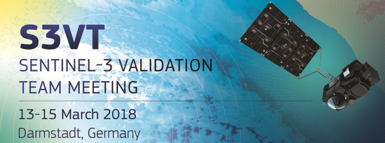 The fourth S3VT meeting will be held 13-15 March 2018 in Darmstadt, Germany, at the EUMETSAT Headquarters. Registration is open on the conference website and it closes on 1 March 2018. Abstracts can be submitted for oral or poster presentations with the deadline of 31 January. Looking forward to seeing you in Darmstadt in March 2018!
Updates on Sentinel-3 OLCI
From January 15, a reprocessed version (baseline 2.23) of the Level 1 and Level 2 Ocean Colour data from OLCI aboard Sentinel-3 is available from EUMETSAT. The reprocessing delivers a consistent OLCI full mission time series from 26 April 2016 and matches the current operational processing. Three improvements have been implemented in this processing version. Firstly, the OLCI Radiometric Evolution Model, which ensures long-term stability of Level-2 products, has been upgraded. A reduction in occurrence of horizontal and vertical striping in products has been achieved with both an updated configuration of Dark Correction to limit dark-offset periodic noise, and filtering of High Energy Particles from radiometric calibration data. Improvements have also been made with regards to inland waters, including updated flagging of Complex Water Neural Network (NN) products to eliminate masking of inland waters, and updated gaseous correction in Open Water products.
Full details on the reprocessing, and information on accessing the reprocessed and current data to obtain a consistent time series of OLCI data is available here: https://www.eumetsat.int/website/home/News/DAT_3775853.html. For more information on the OLCI products and to access the Sentinel-3 OLCI Marine User Handbook check out the S3OceanColour website.
Sentinel-3 Marine Data Training Opportunities
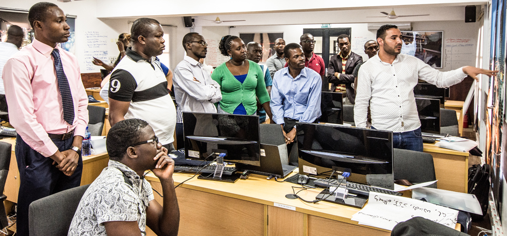
Training on the EUMETSAT Copernicus Marine Data Stream in progress at the University of Ghana in Accra, Ghana.
Over the last 6 months EUMETSAT, supported by a team from Plymouth Marine Laboratory, CLS, Brockmann Consult, and Imperative Space, have been developing and implementing training activities for Sentinel 3 marine data.
Two week courses are now running several times a year to introduce participants to the Copernicus Marine Data Stream, covering ocean colour, SST and altimetry. The courses consist of a week of online content, and an interactive week in classroom for practical tutorials and participant-led mini project work supported by trainers. So far these courses have been run with the support of the IODE in Oostende, and the University of Accra in Ghana. The next of these courses will take place with the support of LEGMC in Riga, Latvia. Other training events have also taken place in collaboration with community events; including conferences (at IOCS in Lisbon, and SAFARI2 in Kochi), and workshops (at the recent GODAE summer school). Upcoming confirmed events will take place in collaboration with COST and BSH, in Hamburg, the IOCCG Summer Lecture Series, and at the Ocean Optics conference. Further collaborative events are planned to focus specifically on SST and altimetry. Training opportunities that are open for applications can be found at http://training.eumetsat.int
In addition to training events, an array of training resources for independent learning is being developed. Video tutorials for data access, and basic visualization and quality assessment with SNAP, are now available on the EUMETSAT YouTube channel
Please contact Copernicus.training@eumetsat.int and hek@pml.ac.uk for further information or to discuss collaborative opportunities for training.
Sentinel-3 OLCI Inherent Optical Properties
The last two decades have been characterized by an increased interest in inverse methods dedicated to the estimation of inherent optical properties (IOPs) of natural surface waters from ocean colour remote sensing observations. The ability to retrieve IOPs from space offers particular benefits of improving the investigations of biogeochemical status of the surface oceanic layer at large basin and global scales over long periods of time. Observation of IOPs from space also allows monitoring of water quality status of coastal and inland waters at unprecedented spatio-temporal scales. Hubert Loisel (LOG, France) together with colleagues from LOV and ACRI will undertake a 12-month study aimed at developing IOP products for Sentinel-3 OLCI as part of a EUMETSAT Copernicus study. They will implement a review process as well as product validation using two kinds of semi-analytical approaches (one-step and two step algorithms). First, semi-analytical models, which aim at simultaneously estimating the backscattering and absorption components of total IOPs using reflectance data as input to the inversion algorithms, will be tested. These one-step algorithms will be developed within the GIOPs framework (Werdell et al., 2013). The second family (two-step algorithms) will assess total IOPs then estimate the components’ IOPs in a stepwise fashion. Synthetic and in situ data sets collected in open-ocean, coastal and inland waters will be used for validation, and uncertainties will be provided for each parameter. An international science team will be associated with the project to review the study.
News from NASA
 Reprocessing for SNPP/VIIRS and MODIS-Aqua
In mid-December 2017, the Ocean Biology Processing Group (OBPG) at NASA completed the ocean colour reprocessing for Suomi NPP/VIIRS. All Level-2 and Level-3 products distributed by the NASA Ocean Biology – Distributed Active Archive Center (OB.DAAC), through the NASA ocean color web now reflect the R2018.0 reprocessing changes.
Full-mission ocean colour reprocessing of the data from MODIS-Aqua was also recently completed. This reprocessing is part of a multi-mission effort to update the instrument calibrations and vicarious calibration. Sensor-independent changes are detailed in the R2018.0 Ocean Color Reprocessing General Description. Full details of the MODIS-Aqua reprocessing 2018.0 are described on the NASA website, and an assessment of data quality and impact relative to the previous R2014 MODISA reprocessing is also provided. Reprocessing of the SeaWiFS and MODIS-Terra missions will soon follow.
Webinar on NASA’s SeaBASS Bio-optical Archive and Storage System
 The featured presentation of the NASA Earthdata Webinar for January was the “Bio-Optical in situ Data Discovery and Access with SeaBASS”, as presented by Joel Scott of NASA’s Ocean Biology Processing Group. SeaBASS, which stands for the SeaWiFS Bio-optical Archive and Storage System, is NASA’s data archive for in situ oceanographic and atmospheric datasets maintained by the Ocean Biology Distributed Active Archive Center (OB.DAAC) at NASA’s Goddard Space Flight Center. In addition to serving as a data repository, SeaBASS operates as a ground-truth, satellite validation and comparison system in support of NASA’s satellite ocean color missions, which take measurements of Earth’s ocean and atmosphere. The webinar focused on how the SeaBASS archive can be accessed and searched, and demonstrated how SeaBASS supports NASA’s ocean color satellite products and the broader scientific community through data management and value-added post-processing features of the SeaBASS tool suite. The webinar also included a brief overview of satellite ocean color remote sensing concepts that are relevant to how the SeaBASS bio-optical archive and validation system functions. A recording of the webinar is available at https://youtu.be/qnSj8otvHHU.
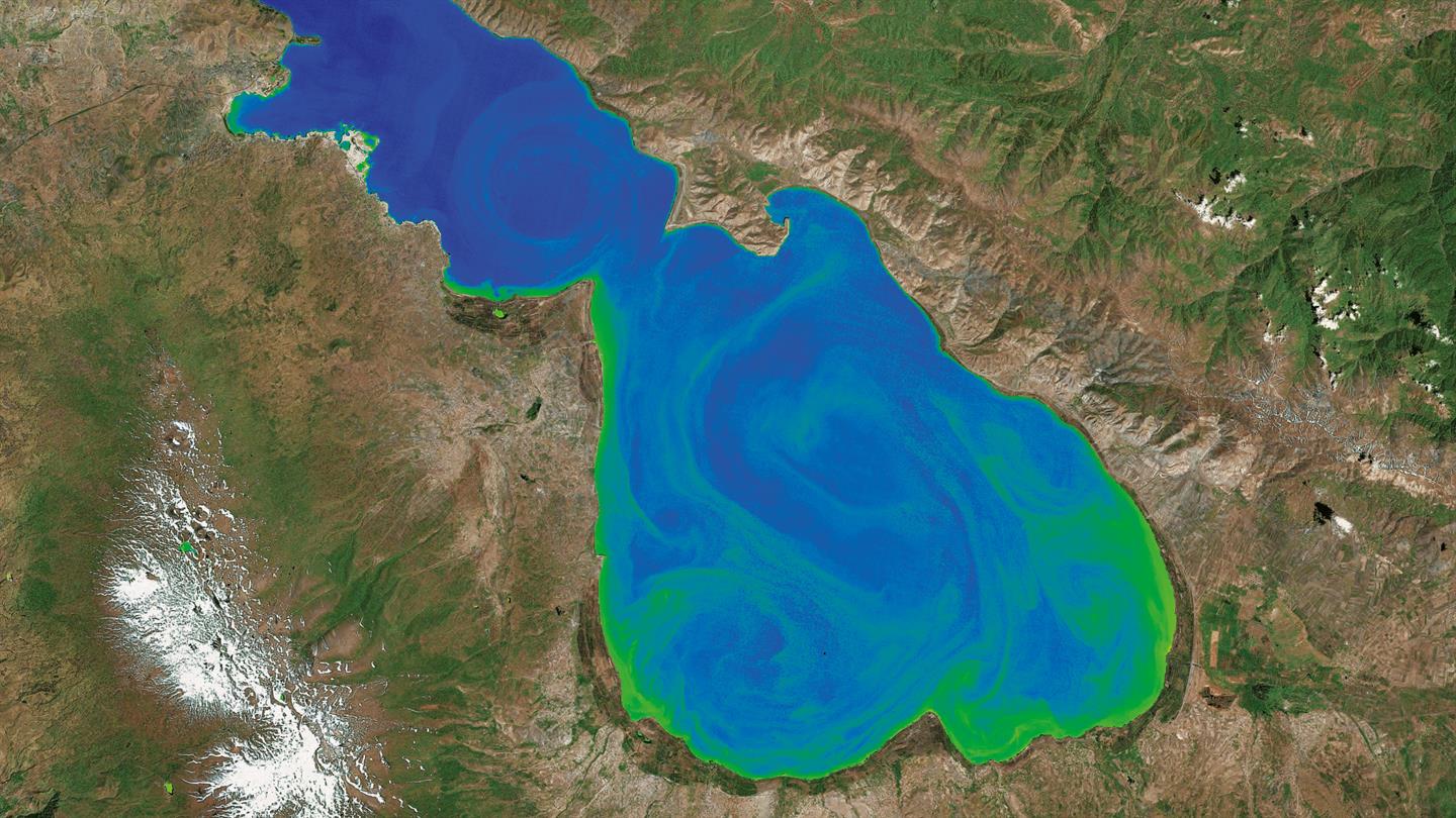
Successful Launch of JAXA’s GCOM-C Mission
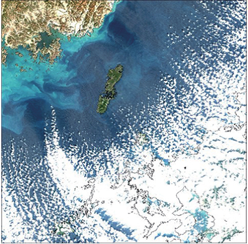
Colour composite image around Tsushima Island captured by SGLI onboard the SHIKISAI on 1st January 2018.
The Japan Aerospace Exploration Agency (JAXA) Global Change Observation Mission – Climate (GCOM-C), also called “SHIKISAI” , was successfully launched on 23 December 2017 from the Tanegashima Space Center in Japan. The payload includes the Second Generation Global Imager (SGLI), an advanced multi-purpose visible/infrared imager of GLI heritage. This instrument will measure ocean colour, land use and vegetation, snow and ice, clouds, aerosols and water vapor. The mission is currently in the commissioning phase and the function of all the onboard sensors and other instruments will be verified.
The primary goal of the GCOM-C mission is to contribute to surface and atmospheric measurements related to climate change with emphasis on the carbon cycle and the radiation budget. JAXA recently released some of the first observation images of the Earth acquired by GCOM-C, including composite images of land vegetation, aerosols over the Ganges River and ocean colour composite images from the sea around Japan. See http://suzaku.eorc.jaxa.jp/GCOM_C/monitor/gallery/20180112.html for further details.
JAXA will continue the initial functional verification of the satellite and instruments (for about three months after launch) after which data accuracy will be confirmed, and initial calibration and data correction performed. GCOM-C data, including Level-1, will be open to the public one year after the launch.
News from NOAA
![]()
NOAA SDR Improvements for VIIRS NOAA-20 as of 5 January 2018
Significant improvements to the NOAA Satellite Data Record (SDR, i.e., L1B) for VIIRS NOAA-20 for calibration and geolocation were implemented as of 5 January 2018. NOAA MSL12 ocean color products are quite improved with this update, for example, chlorophyll now looks more consistent with VIIRS SNPP (see both NOAA-20 and SNPP global true color images and OC product images side-by-side on the NOAA/STAR Ocean Color website). Thanks to the NOAA VIIRS SDR team for their quick response. The NOAA Ocean Color Team is automatically and routinely processing VIIRS NOAA-20 and has been processing daily ocean color data in near-real-time for VIIRS NOAA-20 since its door opened on 13 December 2017 but with sporadic Satellite Data Record (SDR, i.e., L1B) input. Of course, there is still work to be done at this early stage. Ocean Color data products for VIIRS NOAA-20 can be viewed in OCView and will be distributed through NOAA CoastWatch/OceanWatch. For more about JPSS NOAA-20, see this announcement by Paul DiGiacomo.
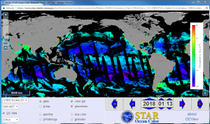
Screen shot of OCView showing global NOAA MSL12 ocean color chlorophyll from VIIRS NOAA-20. Click on photo to access this image in the OCView tool.
News from ESA
Copernicus Data and Information Access Services (DIAS).
![]() Vast quantities of environmental satellite data are now freely available to users, thanks to the European Union’s Copernicus Programme. The European Commission (EC) is now making it easier to access this data and information and also avoid issues associated with downloading and storing the data. To this end, the EC has launched the Copernicus Data and Information Access Services (DIAS). ESA, acting on behalf of the EC, has signed DIAS contracts with four industrial consortia.
Vast quantities of environmental satellite data are now freely available to users, thanks to the European Union’s Copernicus Programme. The European Commission (EC) is now making it easier to access this data and information and also avoid issues associated with downloading and storing the data. To this end, the EC has launched the Copernicus Data and Information Access Services (DIAS). ESA, acting on behalf of the EC, has signed DIAS contracts with four industrial consortia.
DIAS will give unlimited, free and complete access to Copernicus data and information through a cloud computing architecture enabling enhanced coordination and cross-fertilization. Researchers will be able to exploit Copernicus data and information without having to manage transfer and storage on their own computer systems. Early operations are set to start within ~six months, with the demonstration of the infrastructure capabilities, preliminary access to data sets and initial service delivery. DIAS will not only provide a cloud-based one-stop shop for all Copernicus satellite data and imagery as well as information from the six Copernicus services, but will also give access to sophisticated processing tools and resources.
U.S. National Research Council Space Studies Report
 The U.S. National Research Council Space Studies Board released the report of their study, “Thriving on Our Changing Planet: A Decadal Strategy for Earth Observation from Space: 2018” on January 5, 2018. It can be downloaded for no charge from the URL below (see link on right-hand side of page):
https://www.nap.edu/catalog/24938/thriving-on-our-changing-planet-a-decadal-strategy-for-earth
The Ecosystem Panel report (Chapter 8), which is a component of the larger document, discusses terrestrial and ocean science questions, objectives and observations. It prioritizes the objectives and observations.
It should be noted that the Steering Committee report (Chapters 1-5), also included in the larger document, is less favorable to ocean space observations than the reports of the Ecology and Climate panels.
Upcoming Meetings 2018
 2018 Ocean Sciences

The deadline for registration for the 2018 Ocean Sciences meeting is 10 February 2018. The scientific program can be viewed online and has many ocean colour-related sessions as well as interesting Town Halls including:
- PACE: NASA’s Next Generation Aerosol, Cloud and Ocean Color Satellite Mission
- The Future of Remote Sensing of Coastal and Inland Waters
- NOAA Ocean Satellite Data Products for Science and Applications.
SPIE Asia Pacific Remote Sensing
The conference Remote Sensing of the Open and Coastal Ocean and Inland Waters will take place from 24 – 27 September 2018 in Honolulu, Hawaii. See “Call for Papers” for further details. Submit abstracts by 14 March 2018.
UNESCO World Water Quality Portal
 The UNESCO Water Quality Portal (http://www.worldwaterquality.org/) created by EOMAP, is a visualizer of satellite-derived water quality information for worldwide lakes, rivers and coastal areas. The application allows users to interactively browse water quality products (e.g., turbidity, suspended matter, chlorophyll-a, harmful algae blooms) to select the region of interest and display various water quality parameters. These map-based time series of water quality parameters are available in a range of temporal and spatial resolutions and are highly customizable.
New Publications
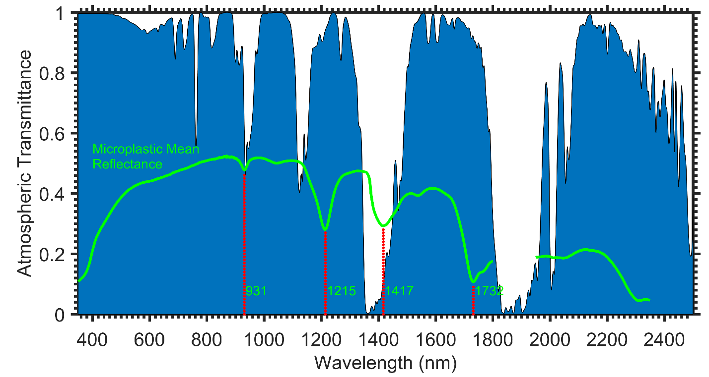
Modeled atmospheric transmittance spectrum (Gao et al. 2000) showing spectral regions where identified features in dry marine-harvested microplastic bulk mean signal can be observed through an intervening atmosphere (click to enlarge).
Several new publications have been added to the IOCCG Recent References list including a paper by Garaba and Dierssen (2018) who present some of the first spectral reflectance measurements of marine-harvested macro- and microplastics to potentially develop remote sensing methods for marine plastics. In their study, microplastic (< 5 mm) specimens were harvested from North Atlantic Ocean and Hawaii, and macroplastics (> 5 mm) were washed ashore along the USA west coast. In all specimens, distinct absorption features were identified at ~931, 1215, 1417 and 1732 nm. Moreover, the reflectance data of the microplastics was similar enough to develop an average microplastic endmember (see Figure). When compared to a spectral reference library of dry virgin plastic pellets (Garaba and Dierssen, 2017), the mean dry marine-harvested microplastics reflectance had moderate similarities to low-density polyethylene, polyethylene terephthalate, polypropylene and polymethyl methacrylate. This was consistent with the subset sampled with the Fourier Transform Infrared (FTIR) spectrometer and what has been reported globally.
The absorption features at 1215 and 1732 nm were observable through an intervening atmosphere (see Figure) and used to map the distributions of synthetic hydrocarbons at a landfill and on man-made structures from airborne visible-infrared imaging spectrometer imagery, indicating the potential to remotely sense dry washed ashore and land-origin plastics. These same absorption features were identifiable on wet marine-harvested microplastics, but the ability to conduct remote sensing of microplastics at the ocean surface layer will require more detailed radiative transfer analysis and development of high signal-to-noise sensors. The spectral measurements presented here provide a foundation for such advances towards remote detection of plastics from various platforms.
In a recent study by Chase et al. (2017), hyperspectral reflectance measurements (Rrs(λ)) at various in situ locations around the world were used to estimate phytoplankton accessory pigments via an inversion algorithm. The inversion algorithm defines phytoplankton pigment absorption as a sum of Gaussian functions, thus providing an analytical rather than empirical approach to identifying the presence of several accessory pigments. The inverted amplitudes of the Gaussian functions representing pigment absorption were compared to coincident High Performance Liquid Chromatography (HPLC) measurements of pigment concentration for method evaluation and determination of the statistical capabilities of the approach.
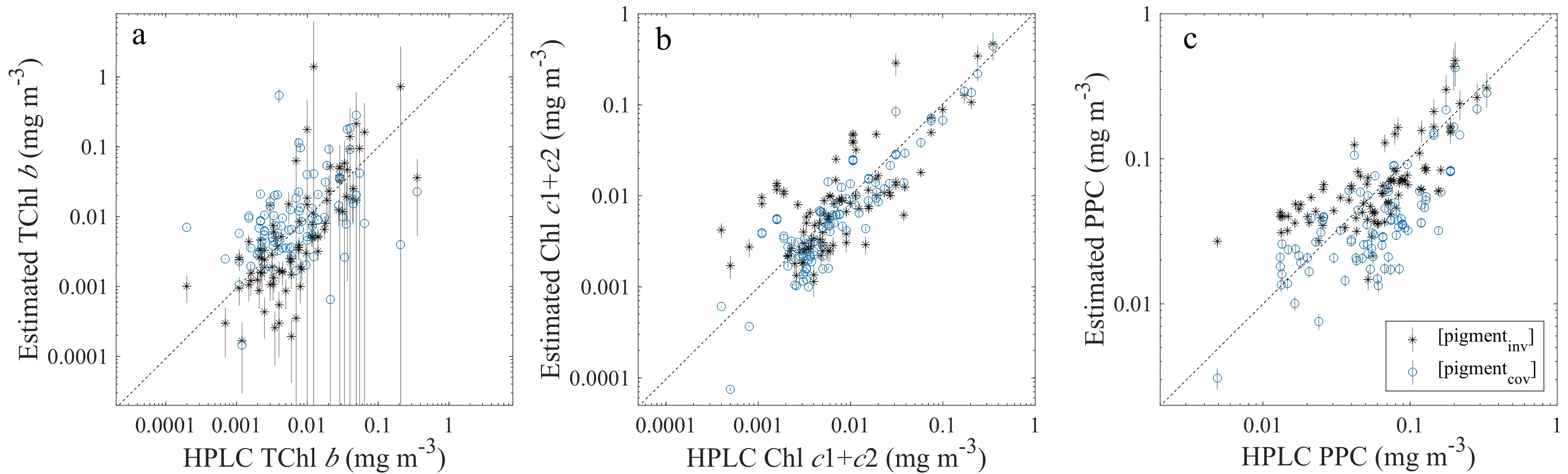
Comparisons between HPLC pigment concentrations (x-axes) and pigments estimated both from peak Gaussian absorption following inversion of Rrs(λ) (black *) and from covariation relationships between chlorophyll a and accessory pigments (blue open circles) (click image to enlarge).
The study found strong predictive capability for chlorophylls a, b, c1+c2, and the photoprotective carotenoids (PPC). The estimation of pigment concentrations from reflectance-derived chlorophyll a using global relationships of covariation between chlorophyll a and the accessory pigments was also tested, and similar errors in pigment estimation were found based on the relationships of covariation versus the inversion algorithm. Ultimately, the study shows that concentrations of three chlorophylls and the PPC pigments are able to be estimated from hyperspectral Rrs(λ), noting that further work is necessary to address the challenge of extracting information from hyperspectral reflectance beyond the information that can be determined from chlorophyll a and its covariation with other pigments.
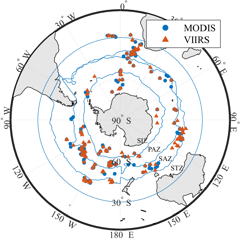
SOCCOM Bio-Argo float and ocean colour matchup locations.
Another interesting publication by Haëntjens et al. (2017) uses data from the Southern Ocean Carbon and Climate Observations and Modeling (SOCCOM) bio-Argo floats to extend discrete samples observations (pigment and particulate organic carbon (POC) analysis) in the Southern Ocean (defined as south of 30ºS) to validate chlorophyll a and POC algorithms on MODIS and VIIRS sensors. The authors found that the default ocean colour algorithm to estimate chlorophyll a concentrations from band ratios (OCI) performs well in the Southern Ocean (bias of 9% for VIIRS and 12% for MODIS, RMSE = 0.1 μg L-1 for both). POC estimates from Stramski et al. 2008 (using the default ocean colour algorithm) agree well with the float products, however, its prediction capability is limited. Autonomous floats can be used as a third dimension (depth) to complement remote sensing in the Southern Ocean as well as to retrieve observations under clouds or during the polar night.
 Widespread pelagic Sargassum macroalgae blooms have only been reported in the Atlantic and Gulf of Mexico, but a recent study by Qi et al. (2017) showed similar blooms in the western Pacific as well. The spring 2017 bloom was first thought to be Ulva, but spectral diagnostics indicated Sargassum honeri. Unlike the Atlantic Sargassum whose entire life cycle is in surface waters, S. honeri usually grows on bottom rocks, which can be detached and float on ocean surface. The multi-sensor study showed recurrent blooms since 2012, with the largest bloom in 2017 that appears to be a result of record-high water temperature, higher than usual light availability, and continuous expansion of coastal aquaculture.
Drs. Wei Shi and Menghua Wang (2018) just published a paper in Remote Sensing (8 January 2018 issue) showing a new application using Day/Night Band (DNB) observations of the Visible Infrared Imaging Radiometer Suite (VIIRS) onboard the Suomi National Polar-orbiting Partnership (SNPP) to observe ocean dynamics. The idea for this research came about during a dinner discussion during the International Ocean Colour Science meeting in Lisbon last May 2017.
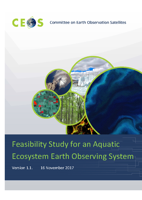 The “Feasibility Study for an Aquatic Ecosystem Earth Observing System”, with contributions from many research scientists as well as space agency experts, and edited by Dekker and Pinnel (2017), focuses on the requirements for a dedicated Earth observing mission for freshwater, estuarine and coastal water quality observations. As a CEOS action, CSIRO and DLR took the lead on this report to determine the benefits and technological difficulties of designing an Earth observing satellite mission focused on the biogeochemistry of inland, estuarine, deltaic and near coastal waters as well as mapping macrophytes, macro-algae, sea grasses and coral reefs. These environments need higher spatial and spectral resolution than current and planned ocean colour sensors and land Earth observing sensors offer.
The results indicate that a dedicated sensor of (non-oceanic) aquatic ecosystems could be a multispectral sensor with ~26 bands in the 380-780 nm wavelength range for retrieving the aquatic ecosystem variables as well as another 15 spectral bands between 360-380 nm and 780-1400 nm for removing atmospheric and air-water interface effects. The spatial resolution of such a global mapping mission would be between ~17 and ~33 m enabling imaging of the vast majority of water bodies (lakes, reservoirs, lagoons, estuaries etc.) larger than 0.2 ha and ~25% of river reaches globally (at ~17 m resolution) whilst maintaining sufficient radiometric resolution. The report, which is currently being presented for CEOS endorsement, can be viewed here.
Employment Opportunities
Several new positions have been added to Employment Opportunities on the IOCCG website including PhD/post-doc positions at the University of Waterloo (Canada), Université du Québec à Rimouski (Canada), Nantes University (France), University of North Carolina Wilmington (USA) and University of Vigo (Spain), as well as Research Assistant/full time research positions at the University of Stirling (UK) , Plymouth Marine Laboratory (UK), City College of the City University of New York (CCNY) and Sun Yat-sen University (China).
