This IOCCG news bulletin contains a summary of the latest news from the IOCCG and its sponsoring agencies, as well as the broader ocean colour community. If you would like to include a news item in the next IOCCG news bulletin, please contact the IOCCG Project Coordinator, Dr. Venetia Stuart (vstuart@ioccg.org). If you are having trouble receiving emails from IOCCG on your network, please see instructions on how to Whitelist “Campaign Monitor” (the IOCCG email marketing platform). Please also Whitelist vstuart@ioccg.org and ioccg@ioccg.org (especially important for subscribers with Gmail accounts – check your SPAM folder).
IOCCG News
New IOCCG Task Force on Remote Sensing of Marine Litter and Debris
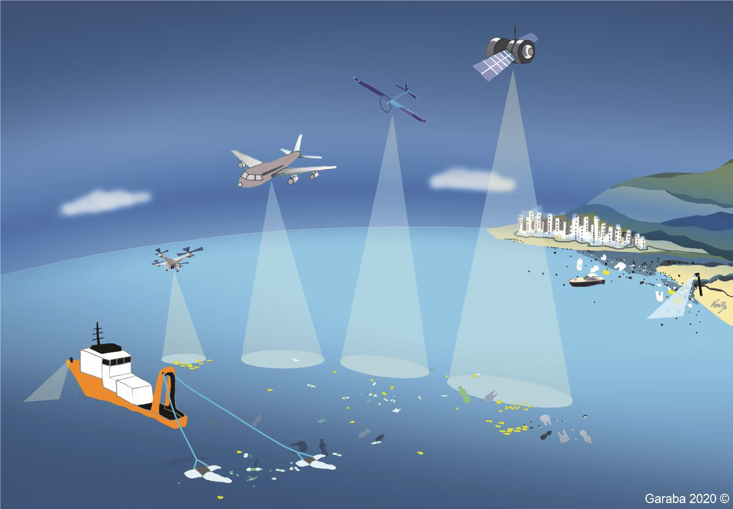
Plastic pollution is an environmental problem that causes injuries and death to countless marine animals and has a wide range of socio-economic impacts with potential implications for human health. In an effort to complement interdisciplinary scientific evidence-based research relevant to aquatic plastics, a new Task Force on “Remote Sensing of Marine Litter and Debris” has been provisionally accepted by the IOCCG Committee. The Task Force was proposed by Shungu Garaba acting as scientific chair (University of Oldenburg, Germany), Manuel Arias (Argans Ltd., France), Lauren Biermann (Plymouth Marine Laboratory, UK), Francois-Regis Martin-Lauzer (Argans Ltd., France) and Victor Martinez-Vicente (Plymouth Marine Laboratory, UK) together with four chairs from national space agencies Paolo Corradi (ESA), Laura Lorenzoni (NASA), Debashis Mitra (ISRO) and Hiroshi Murakami (JAXA). The team plan to gather international experts to coordinate the advancement of current and future remote sensing technologies and techniques that have potential to provide observations of plastic litter in all aquatic environments. The Task Force will start with an assessment of the capability of current ocean colour remote sensors to detect, quantify, characterize and track aggregated aquatic plastic debris, with consideration for new capabilities of future sensors. A dedicated webpage will be available soon on the IOCCG website for this new Task Force.
News from NOAA
![]()
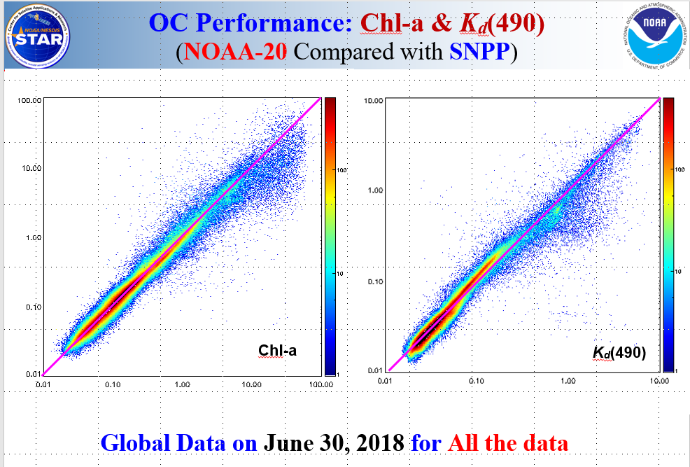
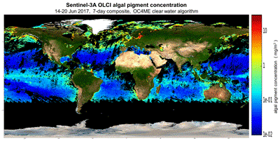
MSL12 Ocean Color Products
The Joint Polar Satellite System (JPSS) review board recently reviewed the maturity readiness for the NOAA-20 Visible and Infrared Imaging Radiometry Suite (VIIRS) Ocean Color products. These products are generated through the Multi-sensor Level 1 to Level 2 processing system (MSL12) by the NOAA Ocean Color Environmental Data Record (EDR) team, led by Menghua Wang with support from external JPSS VIIRS Cal/Val collaborators. The MSL12 ocean color products for NOAA-20 was shown to satisfy a list of quantified metrics (see figures below) with positive user feedback, and has been awarded the status of “validated maturity” defined as:
- Comprehensive documentation of product performance exists that includes all known product anomalies and their recommended remediation strategies for a full range of retrieval conditions and severity level.
- Product analyses are sufficient for full qualitative and quantitative determination of product fitness-for-purpose.
- Product is ready for operational use based on documented validation findings and user feedback.
- Product validation, quality assurance, and algorithm stewardship continue through the lifetime of the instrument.

Call for Abstracts for OSO Symposium
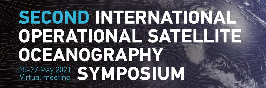 The call for abstracts is now open for the second international Operational Satellite Oceanography Symposium (OSOS-2), co-organized by NOAA/NESDIS/STAR and EUMETSAT, which will be held in a virtual format, on 25-27 May 2021. The second OSO Symposium will build on the first OSO (June 2019) of community members involved in all levels of the observation-to-information value chain, from data providers to users, of operational satellite oceanographic data, products and applications. The Programme Committee will compile the program based on selected abstracts. Abstracts can be submitted online through the conference website at https://www.eventsforce.net/osos2021. Abstract submission deadline 1 March 2021, registration deadline 15 May 2021.
NASA PACE Radiometric Product Survey
 The NASA PACE mission, a hyper-spectral mission spanning from the UV to the NIR, is preparing for launch in 2023. In anticipation, the team would like to develop radiative products that will be most useful for the community. To guide this effort, they are asking potential PACE data users to provide input on what products they would like to see produced from PACE, as the choice of products that will be considered for production will depend on the level of interest with the user community, in addition to considerations such as the degree to which achievable accuracy compares to needed accuracy, the feasibility of implementation, computational requirements, and the availability of data production and distribution resources.
Emmanuel Boss and Robert Frouin, members of the PACE Science and Application Team, have developed a survey to obtain feedback from the user community. Interested parties are requested to complete the survey here. Results from this survey will inform the PACE project and be shared when the survey closes at the end of November, 2020.
News from EUMETSAT
Online Courses
 The training team at EUMETSAT is offering a series of online short courses that are open to all interested participants. On 25 November 2020, Lauren Biermann and Oliver Clements will be offering a course on The Colour of the Oceans, dealing with data from the Ocean and Land Colour Instruments (OLCI) onboard the Sentinel-3 satellites, including data access, visualization and processing. Tools will include Python, Jupyter Notebooks and SNAP. More information about the online series and the course schedule is available at https://training.eumetsat.int/course/index.php?categoryid=97, where participants can also register for the courses. Each short course will offer a webinar with a presentation, a demonstration of data discovery and data application. Some courses will also include a follow-up self-paced phase where participants will have the opportunity to further explore the data and discuss it with experts.
News from ESA
Launch of Copernicus Sentinel-6 Mission
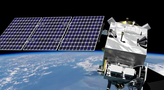
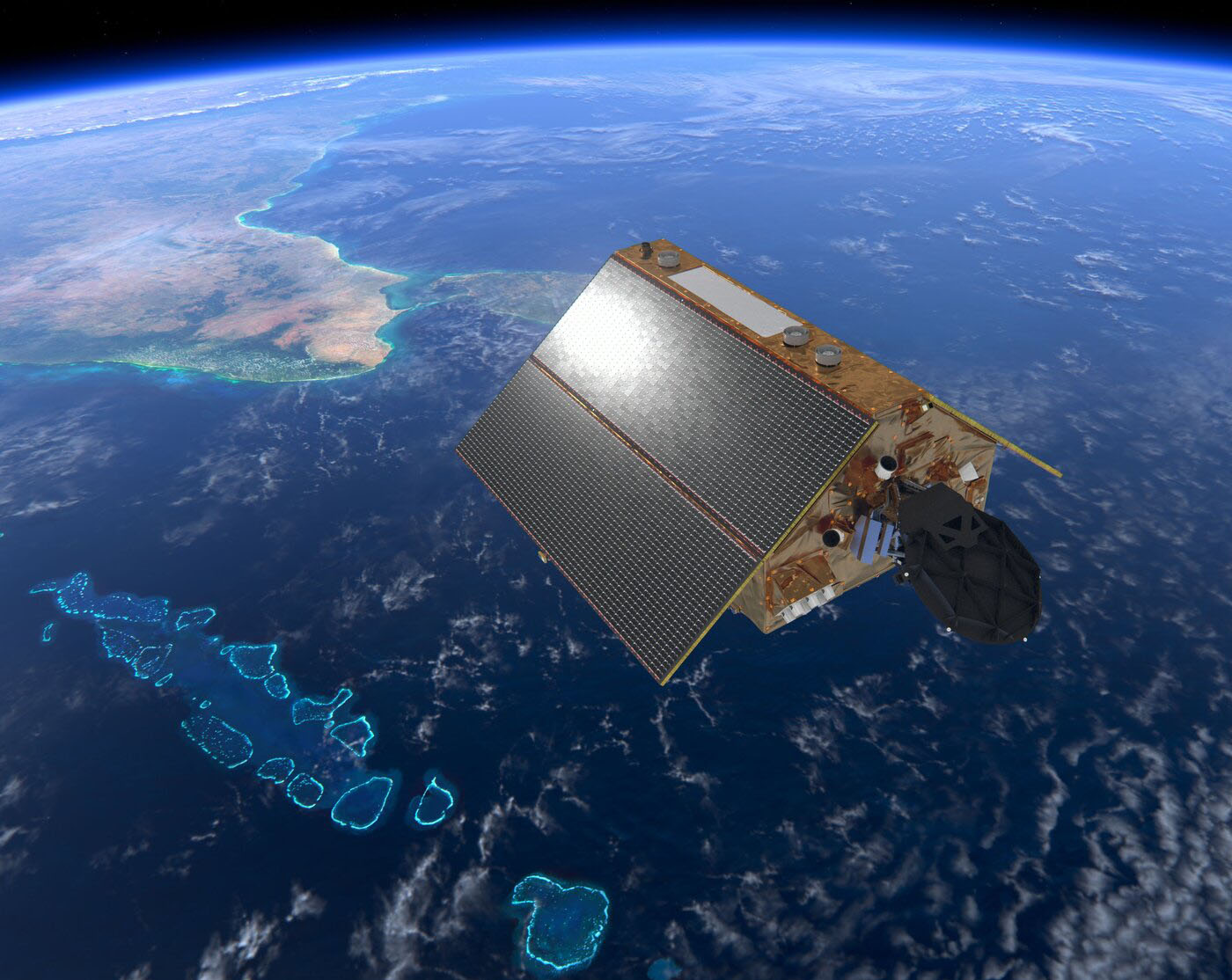 Scheduled for launch on 21 November 2020 from the Vandenberg Air Force Base in California, the Copernicus Sentinel-6 Michael Freilich satellite is the first of two identical satellites to be launched sequentially to provide accurate measurements of sea-level change with a Poseidon-4 radar altimeter and a microwave radiometer. Renamed in honour of Michael H. Freilich, the former director of NASA’s Earth Science Division, the satellite will continue the legacy of the Jason series of missions and extend the records of sea level into its fourth decade. The satellite will map 95% of Earth’s ice-free ocean every 10 days and provide crucial information for operational oceanography and climate studies. The Copernicus Sentinel-6 mission is a true example of international cooperation. While Sentinel-6 is one of the European Union’s family of Copernicus missions, its implementation is the result of the unique collaboration between ESA, NASA, EUMETSAT and NOAA, with contribution from the French space agency CNES
Ocean Colour Journals
New Journal of Remote Sensing
 The American Association for the Advancement of Science (AAAS) recently announced the launch of a new journal, the “Journal of Remote Sensing”, published in affiliation with the Aerospace Information Research Institute, Chinese Academy of Sciences (AIR-CAS). The journal’s mission is to promote high-quality publications that benefit the Earth observation community. The scope of the journal will focus on the theory, science, and technology of remote sensing, as well as interdisciplinary research with Earth science and information science. The journal is currently open for submissions and will publish under a Creative Commons Attribution License (CC BY).
Special Issue in Remote Sensing
![]() The journal Remote Sensing is offering a special issue on “Remote Sensing in Aquatic Vegetation Monitoring”. Macrophytes provide habitat and food for fish and aquatic invertebrates, and are indicators for changing environmental conditions. Ship-, air- and spaceborne remote sensing approaches can support inventory and monitoring of macrophytes. Currently, optical systems are mostly used to analyze spatial, spectral or temporal changes and deliver information on bathymetry. This special issue is now open for submission (deadline for manuscript submissions: 31 January 2021).
The journal Remote Sensing is offering a special issue on “Remote Sensing in Aquatic Vegetation Monitoring”. Macrophytes provide habitat and food for fish and aquatic invertebrates, and are indicators for changing environmental conditions. Ship-, air- and spaceborne remote sensing approaches can support inventory and monitoring of macrophytes. Currently, optical systems are mostly used to analyze spatial, spectral or temporal changes and deliver information on bathymetry. This special issue is now open for submission (deadline for manuscript submissions: 31 January 2021).
Upcoming Conferences and Webinars
GEO AquaWatch Webinar: Nov 12, 2020 2:00 – 3:00 PM (GMT)
![]() GEOAquaWatch webinar entitled “LIMNADES Database Demonstration” by Adam Varley (University of Stirling, Scotland) will take place on 12 November 2020, 2-3 pm (GMT) . The LIMNADES (Lake Bio-optical Measurements and Matchup Data for Remote Sensing) data repository was a concept formed during the GloboLakes research project, which ended in 2018. The database is still maintained at the University of Stirling and poised to become a preferred data repository for inland water quality calibration/validation data. The purpose of the LIMNADES project is to provide a centralised database of ground bio-optical measurements of worldwide lakes through voluntary cooperation across the international scientific community. To join the meeting go to: https://www.gotomeet.me/GEOAquaWatch/geoaquawatch-webinar–limnades-database-demonstrat
GEOAquaWatch webinar entitled “LIMNADES Database Demonstration” by Adam Varley (University of Stirling, Scotland) will take place on 12 November 2020, 2-3 pm (GMT) . The LIMNADES (Lake Bio-optical Measurements and Matchup Data for Remote Sensing) data repository was a concept formed during the GloboLakes research project, which ended in 2018. The database is still maintained at the University of Stirling and poised to become a preferred data repository for inland water quality calibration/validation data. The purpose of the LIMNADES project is to provide a centralised database of ground bio-optical measurements of worldwide lakes through voluntary cooperation across the international scientific community. To join the meeting go to: https://www.gotomeet.me/GEOAquaWatch/geoaquawatch-webinar–limnades-database-demonstrat
EO 4 Water 2020: 16-18 November 2020
 The EO 4 Water Cycle Science 2020 upcoming virtual conference (16-18 November 2020) aims at reviewing the latest advances in the use of Earth observation (EO) technology for scientific questions related to the water cycle and its applications, exploring the potential offered by the coming EO as well as the main challenges and opportunities. The new virtual concept will also feature discussion sessions focused on major science challenges in water research, where EO may provide a major contribution in the coming few years. More information can be found here.
S3VT Meeting: 15-17 December 2020
 The Sentinel-3 Validation Team virtual meeting will be organized around five application areas: Ocean Colour, Altimetry, Sea Surface Temperature, Land, and Atmosphere. The Ocean Colour sessions will focus on the scientific validation of the operational products, upcoming OLCI algorithm updates, new user tools, as well as on the FRM-quality of in situ radiometry and the related study – FRM4SOC-phase2. The draft agenda is already available to the S3VT members. For last minute registrations, please see the website or contact the organizing committee at s3vtm@eumetsat.int.
Fall AGU Meeting: 7-11 December 2020
![]() The AGU20 Fall Meeting will be one of the largest virtual scientific conferences, with exciting programming and events, and will accommodate over a thousand hours of virtual content to minimize conflicts while maximizing global engagement. Scientific program will include pre-recorded oral presentations and virtual posters available for attendees to view outside of the scheduled live Q&A sessions during the meeting. More information and a link to submit abstracts can be found here.
The AGU20 Fall Meeting will be one of the largest virtual scientific conferences, with exciting programming and events, and will accommodate over a thousand hours of virtual content to minimize conflicts while maximizing global engagement. Scientific program will include pre-recorded oral presentations and virtual posters available for attendees to view outside of the scheduled live Q&A sessions during the meeting. More information and a link to submit abstracts can be found here.
Second OSO Symposium: 25-27 May 2021
The second international Operational Satellite Oceanography (OSO) symposium will be held in a virtual format on 25-27 May 2021, and will focus on the use of satellite data in coupled numerical models for ocean, weather, climate and environment analysis and prediction, as well as operational applications for coastal waters. A call for abstracts has been released, with an abstract submission deadline of 1 March 2021. Registration is free (deadline: 15 May 2021). See conference website for further details.
Funding Opportunities
- Searchable database of grants and fellowships from around the world for Graduate Students, Postdoctoral Students and Early Career Scientists, produced by Johns Hopkins University, Maryland, USA. The databases are updated monthly.
- Ocean Carbon and Biogeochemistry (OCB) program continually updated list of OCB-relevant federal agency funding opportunities (USA).
- NASA ROSES-2020 Program Element A.5 Carbon Cycle Science solicits proposals for research focused on carbon stocks and fluxes between and within freshwater, marine systems, and land ecosystems, and their exchange with the atmosphere. Substantive use of remote sensing and/or airborne data is required. Proposals due 3 December 2020.
- National Science Foundation (NSF) Division of Ocean Sciences Postdoctoral Research Fellowship Opportunities for 2021 to provide opportunities for scientists early in their careers to work within and across traditional disciplinary lines, develop partnerships, and avail themselves of unique resources, sites, and facilities.
- NOAA Climate Program Office FY2021 funding opportunity. The Climate Program Office manages competitive research programs through which NOAA funds high-priority climate science, assessments, decision support research, outreach, education, and capacity-building activities designed to advance the understanding of Earth’s climate system and to foster the application of this knowledge to enable effective decisions.
- EUMETSAT Skills Development Award provides opportunities to advance skills in the field of satellite data analysis and exploitation, by offering short-term placements, where award holders travel to EUMETSAT or another institution; or your organization hosts an expert from another institution. This grant will support the costs associated with the exchange visit.
- ESA Business Applications’ Call for proposals. Businesses from any sector can apply throughout the year, and the amount of funding may vary according to the project. The goal of this activity is for the business to develop a new commercial service that utilises one or more space asset.
- ESA Open Discovery Ideas Channel. Do you have a novel idea for an activity (e.g. early technology development, study, co-funded PhD, post-doc)? This call for idea channel is for you.
- NERC Knowledge Exchange Fellowships. The Natural Environment Research Council (NERC) fellowships (UK) are intended to enable the sharing and flow of knowledge and expertise between NERC funded researchers and their stakeholders, partners and/or user communities with the aim of generating impact from NERC funded research in the priority areas.
- NERC Announcement of Opportunity: Changing the Environment. NERC invites eligible research organisations to submit proposals for large scale inter-disciplinary research and innovation funding to provide whole system solutions to major environmental challenges.
New Publications
In a recent publication, Collister et al. (2020) used a shipboard polarized oceanographic lidar system to map the distribution of lidar attenuation (α) and depolarization (δ) across a dense coccolithophore bloom that occurred in the lower Gulf of Maine. Throughout the expedition, optical and biogeochemical properties were measured continuously at the surface, allowing the authors to characterize the response of α and δ to changes in the abundance and composition of suspended particles. α was consistent with the diffuse attenuation coefficient (Kd), and was found to be insensitive to large changes in the composition of the particle assemblage that were encountered as the expedition crossed through a variety of optically and biogeochemically distinct water masses. δ showed a positive relationship to both the calcite fraction of backscattering and the scattering optical depth, highlighting the sensitivity of δ to both the intensive and extensive (concentration independent and concentration dependent) properties of the particle assemblage. A statistical fit to these data suggests that the polarized light scattering properties of calcified particles are distinct and that polarized lidar can be used to discriminate between calcified and non-calcified marine particles. While many questions remain regarding the polarized scattering properties of marine particles, these results provide some exciting support for the idea that polarized oceanographic lidar can be used to measure the material properties of marine particles remotely.
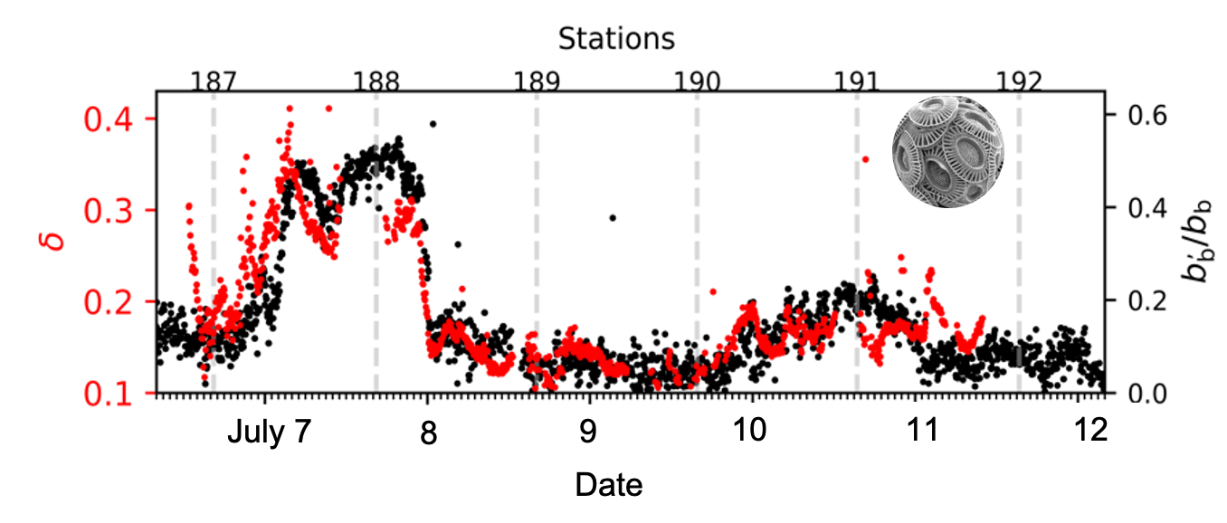
Time series plot of the acid-labile backscattering ratio (bb’/bb; black), an optical proxy for the calcite fraction of backscattering, and the lidar depolarization ratio (δ; red).
 In another recent publication Pitarch (2020) brings the seminal document on the Secchi disk (Secchi, 1865) back to the community, and reanalyzes the data from a modern perspective, in context with several other relevant early references. The Secchi disk owes its name to the astrophysicist, Angelo Secchi (1818-1878), despite the fact that similar devices were being used routinely to measure water transparency before his time. How did Secchi win the battle for the credit? The answer is found in the report he wrote on a cruise where he investigated the transparency and colour of seawater. Secchi was able to identify dependence of the Secchi disk depth on the sun angle, the cloud cover, the disk’s size, colour and material, the wave field and the sun glint. He showed how spectral differences in the light extinction rates modify the perceived colour and influence the light availability at depth. The paper also contains detailed descriptions of the observations, which were carefully designed to investigate specific phenomena.
This publication has been systematically overlooked in scientific and even historic documents on the topic, which is regrettable because it represents the paradigm of the rigorous science done by Secchi at the time. Secchi‘s report is written in a very pedagogical style, and reports on both positive and negative results, expresses raw thoughts and discussions within the scientific context of the time, and is profoundly reflective and analytical. Pitarch’s review of this report shows how Secchi’s training as an empirical physicist, his meticulousness, and his dedication enabled him to establish the Secchi disk science used in modern oceanography.
Lastly, Organelli et al. (2020) proposed optical models to relate spectral variations in the beam attenuation (cp) and optical backscattering (bbp) coefficients to marine particle size distributions (PSDs). Due to limited PSD data, particularly in the open ocean, optically derived PSDs suffer from large uncertainties and there is a poor empirical understanding of the drivers of spectral scattering coefficients. Organelli et al. (2020) analyzed PSD optical proxies and investigated their drivers by exploring an unprecedented dataset of co-located PSDs, phytoplankton abundances and optical measurements collected across the upper 500 m of the Atlantic Ocean. The spectral slope of cp was correlated with the slope of the PSD only for particles with diameters >1 μm and also with eukaryotic phytoplankton concentrations. The authors observed no significant relationship between PSDs and the spectral slope of bbp. In the upper 200 m, the bbp spectral slope was correlated to the light absorption by particles and to the ratio of cyanobacteria to eukaryotic phytoplankton. This latter correlation was likely the consequence of the strong relationship observed between particulate light absorption and the concentration of eukaryotic phytoplankton.
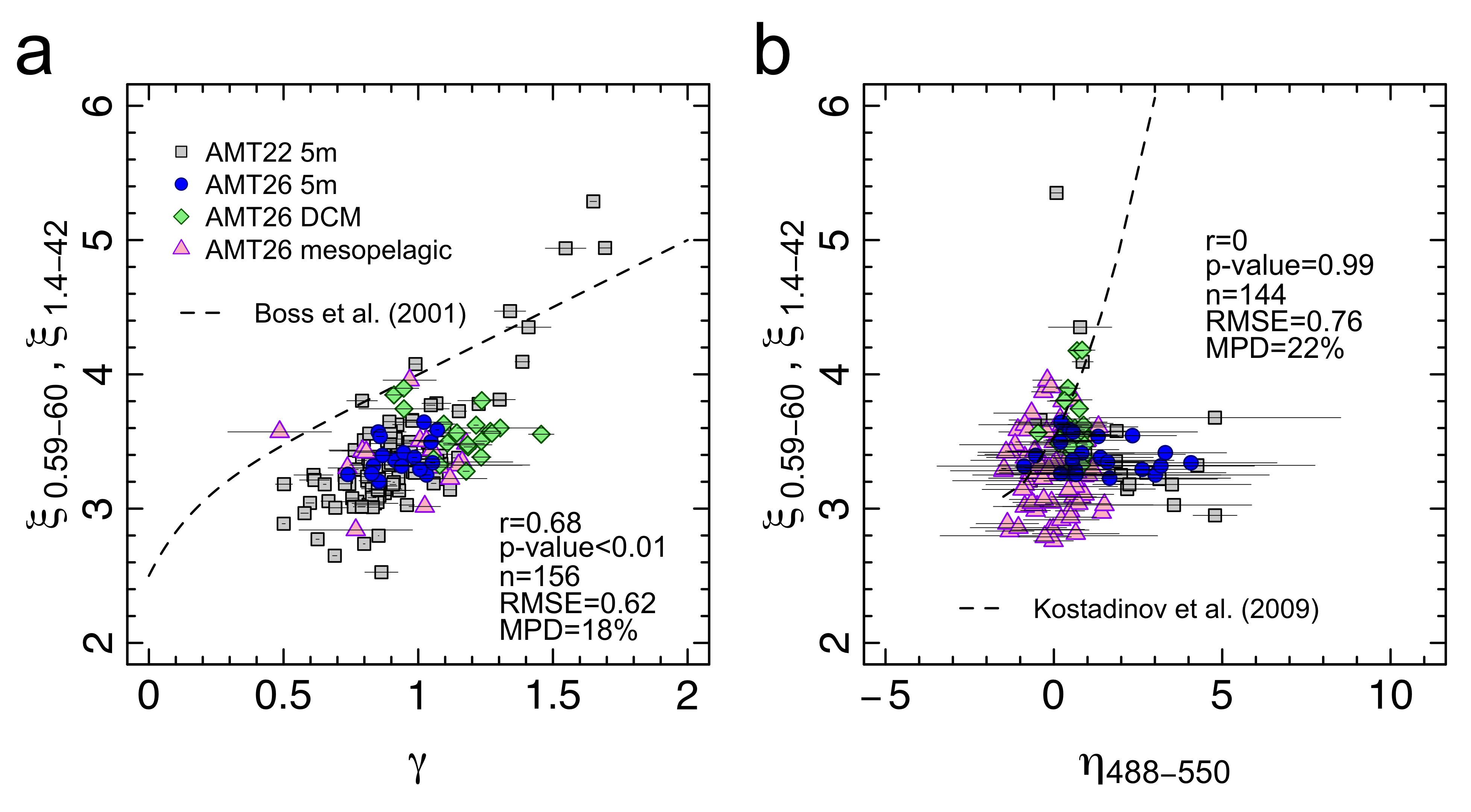
Comparison between the slopes of PSD computed over the entire measured size range and those derived from spectral optical measurements of (a) beam attenuation and (b) particulate optical backscattering coefficients. Particle size distributions were measured by Coulter counter. Data were collected in the upper 500 m of the oligotrophic Atlantic Ocean during two Atlantic Meridional Transect (AMT) field expeditions (click to enlarge).
Employment Opportunities
Several new positions have been added to Employment Opportunities on the IOCCG website including:
- Scientific Officer for the IOCCG
- Research oceanographer at NASA GSFC (USA),
- Director of the Sea Grant Program(RI, USA)
- PhD and post-doc positions at the Helmholtz-Zentrum Geesthacht (Germany)
- Scientist/engineer for optical measurements at the Royal Belgian Institute of Natural Sciences
- Data scientist at the Plymouth Marine Laboratory (UK)
- Analyst for NOAA’s CoastWatch/OceanWatch Program in Honolulu, Hawaii.
For more information on these and other positions see http://ioccg.org/resources/employment-opportunities/
