This IOCCG news bulletin contains a summary of the latest news from the IOCCG and its sponsoring agencies, as well as the broader ocean colour community. If you would like to include a news item in the next IOCCG news bulletin, please contact the IOCCG Project Coordinator, Dr. Venetia Stuart (vstuart@ioccg.org).
IOCCG News
New Benthic Reflectance Working Group
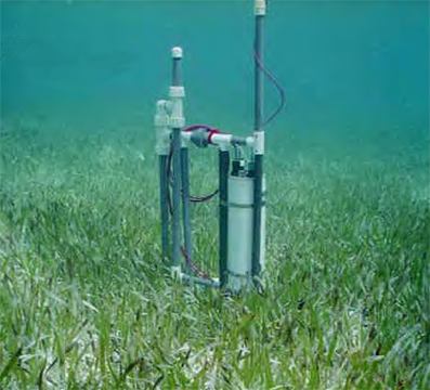 A new IOCCG working group, chaired by Prof. Heidi Dierssen (University of Connecticut, USA), has been established to investigate the different techniques for making benthic reflectance measurements, and to make recommendations for the best practices for each method. “Benthic reflectance” is a measurement describing the colour of the seafloor, and is an essential parameter for mapping benthic marine habitats in optically shallow water using remote sensing techniques. It can also be sued to asses shallow-water bathymetry. It is quantified as the upwelled irradiance reflected from the seafloor normalized to the incident downwelling irradiance. Methods generally involve inversion of the remote-sensing reflectance profile to simultaneously fit both the inherent optical properties of the water column and the bottom spectral reflectance profile. Hyperspectral data, which provide near-continuous spectral measurements across near-ultraviolet, visible, and near infrared wavelengths, offers the best results for discrimination of benthic habitats and specific benthic types such as corals, algae and sand.
This new working group aims to:
- document how these different methods work
- characterize the uncertainties inherent to the measurements
- provide recommendations as to best practices for each method in order to minimize the uncertainty
- provide recommendations for relevant metadata to be included for each dataset
- recommend practices in field validation for benthic remote sensing.
For more information see the link to the IOCCG Benthic Reflectance working group. If you have experience with making benthic reflectance measurements and are interested in contributing your expertise to an IOCCG report on this topic, please contact Prof. Heidi Dierssen (heidi.dierssen@uconn.edu).
IOCCG Trevor Platt Memorial Scholarship
 A new IOCCG scholarship has been established to honour the memory of Prof. Trevor Platt (1942-2020). He was a distinguished scientist with many outstanding scientific contributions in the fields of biological oceanography, theoretical ecology and the use of satellite ocean colour data for measuring ocean processes. He also played a significant role in international coordination efforts, and specifically in the creation of the IOCCG. Trevor was one of the founding members of the group, and also served as the first Chair of the IOCCG for a period of 10 years, from 1996-2006.
The Trevor Platt Memorial Scholarship is aimed at providing students and early career scientists from developing countries with the opportunity for gaining valuable training experience at a foreign institute. The scholarship will be awarded annually, and is open to candidates involved in any aspect of ocean optics and ocean colour research and applications. Application for the IOCCG Trevor Platt Memorial Scholarship will open once global travel restrictions due to the COVID-19 pandemic have been lifted. An announcement will be made via the IOCCG mailing list, so please be sure to subscribe to the IOCCG mailing list. For more information on the scholarship, and how to apply, see https://ioccg.org/what-we-do/training-and-education/platt-scholarship/.
IOCCG Committee Members on the Move
 Congratulations to IOCCG Executive member, Dr. Paula Bontempi, acting deputy director of NASA’s Earth Science Division in Washington, D.C., who has just been appointed as the new dean of the Graduate School of Oceanography at the University of Rhode Island, USA (see https://web.uri.edu/gso/news/uri-appoints-nasa-scientist-to-lead-graduate-school-of-oceanography/ for further details). We are thrilled to report that Paula has agreed to remain on the IOCCG Committee as a scientific committee member, so that we can benefit from her extensive experience and expertise. We are also very pleased to extend a warm welcome Dr. Laura Lorenzoni, the new NASA representative on the IOCCG Executive Committee. Furthermore, we are pleased to welcome back IOCCG scientific member, Dr. Wonkook Kim (Pusan National University, South Korea), who has kindly agreed to serve a second term on the IOCCG Committee.
IOCCG Summer Lecture Series
The 2020 IOCCG Summer Lecture Series, originally scheduled for 22 June – 3 July 2020 in Villefranche-sur-Mer, France, had to be cancelled because of travel restrictions related to the global COVID-19 pandemic. This was a big disappointment for all the selected students. Nevertheless, several of the lecturers offered to conduct online Q&A discussion sessions for these students based on their lectures from the previous 2018 Summer Lecture Series (https://ioccg.org/what-we-do/training-and-education/ioccg-sls-2018/). Many students participated in these sessions found it very helpful for their studies. We thank all the lecturers for dedicating their time to this initiative.
News from ESA
Release of Envisat MERIS 4th Reprocessing Data
![]() The data from the 4th MERIS reprocessing has been released to users and is now freely available from the new ESA Online Dissemination Service for MERIS. The complete Envisat MERIS Full Resolution (FR) and Reduced Resolution (RR) archives spanning from May 2002 to April 2012 have been fully reprocessed with the same processor configuration (MEGS 9). The main changes with respect to the former (3rd) product baseline for MERIS are as follows:
The data from the 4th MERIS reprocessing has been released to users and is now freely available from the new ESA Online Dissemination Service for MERIS. The complete Envisat MERIS Full Resolution (FR) and Reduced Resolution (RR) archives spanning from May 2002 to April 2012 have been fully reprocessed with the same processor configuration (MEGS 9). The main changes with respect to the former (3rd) product baseline for MERIS are as follows:
- Alignment of the MERIS and Sentinel-3/OLCI data processing chains to ensure a continuity of the products derived from these two instruments
- The former MERIS Envisat data format (.N1) has been changed in favour of the Sentinel-3 SAFE format based on a folder of NetCDF files including an xml manifest file
- A number of algorithm and auxiliary data evolutions have been implemented according to recommendations by the MERIS Quality Working Group (QWG)
- The source of the meteo data included in the Level 1 and Level 2 products is now ECMWF Era-Interim
For further information on the MERIS 4th reprocessing data see link below:
https://earth.esa.int/eogateway/news/release-of-envisat-meris-4th-reprocessing-data-new-online-dissemination-service
Detecting Plastic Marine Litter from Space
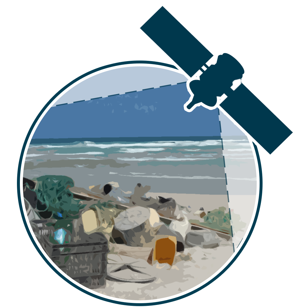 A total of 26 innovative projects submitted via ESA’s Open Space Platform will kick off this summer, to better detect and track seaborne plastic litter using satellites. These projects address different problems, solutions and approaches, from using existing remote sensing technology in novel applications, to exploring new technologies to monitor marine litter, through developing new data processing, modelling and experimental techniques including approaches based on artificial intelligence. Every project has the potential to improve our ability to monitor floating plastic from space, and thus provide the data necessary to propose appropriate solutions. For information on the selected projects see the ESA website.
Ocean Virtual Laboratory
ESA recently funded the development of the Ocean Virtual Laboratory (OVL), a virtual platform that allows oceanographers to discover and explore the various co-located EO datasets and related model/in situ datasets over dedicated regions of interest, with a different multifaceted point of view. It is now possible to exploit the synergy between ESA’s Sentinel 1, 2 and 3 instruments and other mission EO datasets, together with in situ measurements in complex waters, to improve scientific understanding of ocean and coastal processes and impacts.
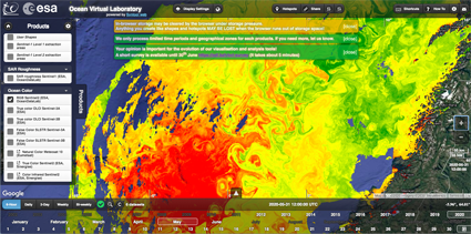
RGB Sentinel-2 and Sentinel-3 OLCI Chl-a (oc4me) image off the coast of Norway (from Ocean Virtual Laboratory website).
The Ocean Virtual Laboratory fills the gap between space agencies’ data portals that distribute EO datasets intended for in-depth analysis, and the requirements of the versatile user community that may wish to rapidly visualize various remote sensing and in situ datasets simultaneously. If you haven’t tried it yet, take a look at the OVL WebClient and play around with the tool. Its development is fully operational and is evolving with users needs.
ESA Lakes Climate Change Initiative
 The ESA Lakes Climate Change Initiative (Lakes_cci) project team is happy to inform you that the first version (1.0) of merged satellite products is now accessible at: https://catalogue.ceda.ac.uk/uuid/3c324bb4ee394d0d876fe2e1db217378. This dataset contains global lake products for five thematic Essential Climate Variables (ECVs) including:
- Lake Water Level (LWL)
- Lake Water Extent (LWE)
- Lake Surface Water temperature (LSWT),
- Lake Ice Cover (LIC)
- Lake Water-Leaving Reflectance (LWLR).
The data generated in the Lakes_cci project are derived from data from multiple instruments and multiple satellites including; TOPEX/Poseidon, Jason, ENVISAT, SARAL, Sentinel, Landsat, ERS, Terra/Aqua, Suomi NPP, Metop and Orbview. For more information on these products see: http://cci.esa.int/lakes
Sentinel-3 Validation Team Call
![]()
The Sentinel-3 Validation Team (S3VT) open call is accessible from the ESA EOPI web page at https://earth.esa.int/aos/S3VT. In the framework of a Copernicus collaborative agreement, the call issued by ESA and EUMETSAT endeavours “To engage world-class validation expertise and activities to complement Sentinel-3 routine validation activities and ensure the best possible outcomes for the Sentinel-3 Mission“. Since the first S3VT workshop in March 2012 and the opening of the S3VT call, there are now more than 300 PIs on the Team. Since then some activities and teams may have evolved. ESA and EUMETSAT would be grateful if you could update your proposal if there are any changes to your team or activities (or submit a new proposal) to better prepare us for S3VT collaborations and the 6th S3VT meeting in December 2020. The deadline for these updates is 15 October 2020. Otherwise, the S3VT call will remain to be open to the community.
News from NOAA
![]()
The VIIRS SNPP global daily 4-km synoptic chlorophyll anomaly product generated routinely by the NOAA Ocean Color EDR team, and which has been viewable on the NOAA OCView tool, is now available through the NOAA CoastWatch Data Portal for both viewing (in context with other ocean and coastal parameters) and subsetting and downloading of NetCDF files (see Figure below). The anomaly, based on the analysis developed by Stumpf, et al. (2003), uses a difference from a 61-day median baseline to identify synoptic chlorophyll blooms. In addition, there is a new chlorophyll-a anomaly ratio product (i.e., relative chlorophyll-a change). The NOAA OC global product suite includes both a difference and a ratio anomaly.
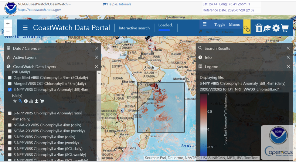
Screenshot of VIIRS SNPP chlorophyll anomaly (difference) product shown on the NOAA CoastWatch Data Portal with an example of a sub-set selection box drawn in the Arabian Sea.
Recent peer reviewed publications from the NOAA Ocean Color science team
Son, S. and M. Wang (2020). Water quality properties derived from VIIRS measurements in the Great Lakes. Remote Sens., 12, 1605. doi:10.3390/rs12101605
Chu, M. and M. Wang (2020). The two-year radiometric evaluation of Sentinel-3A OLCI via intersensor comparison with SNPP VIIRS. IEEE Trans. Geosci. Remote Sens., 58, 4494–4500. doi:10.1109/tgrs.2019.2938974
Wang, M., W. Shi, and S. Watanabe (2020). Satellite-measured water properties in high altitude Lake Tahoe. Water Res., 178,
doi:10.1016/j.watres.2020.115839
Hu, C., B. B. Barnes, L. Feng, M. Wang, and L. Jiang (2020). On the interplay between ocean color data quality and data quantity: Impacts of quality control flags. IEEE Geosci. Remote Sens. Lett., 17, 745–749. doi:10.1109/lgrs.2019.2936220
Shi, W. and M. Wang. (2020). Water properties in the La Plata River Estuary from VIIRS observations. Continent. Shelf Res., 198, 104100. doi:10.1016/j.csr.2020.104100
News from NASA
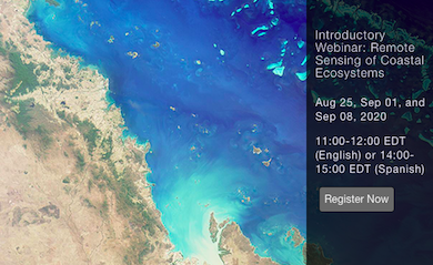 NASA’s Applied Remote Sensing Training program (ARSET) is offering an introductory online training course on Remote Sensing of Coastal Ecosystems (three one-hour sessions with presentations in English and Spanish).
Dates: August 25, September 1, and 8, 2020. Users with little remote sensing experience stand to benefit from this training covering some of the difficulties associated with remote sensing of coastal ecosystems, particularly beaches and benthic communities such as coral reefs and seagrass.
For more information see the training course website and the agenda.
Access to PRISMA Products
![]() The hyperspectral satellite mission PRISMA (http://www.prisma-i.it/index.php/en/), funded by the Italian Space Agency, ASI, has the potential to provide interesting data for the ocean colour community, despite the fact that it was not developed as an ‘aquatic’ mission. The imaging spectrometer takes images with a pixel size of 30 m in a continuum of spectral bands ranging from 400 to 2500 nm. With a repeat orbital cycle of approximately 29 days, the PRISMA system is capable of acquiring images distant 1000 km in a single pass so that the relook time can be significantly reduced to less than one week.
The hyperspectral satellite mission PRISMA (http://www.prisma-i.it/index.php/en/), funded by the Italian Space Agency, ASI, has the potential to provide interesting data for the ocean colour community, despite the fact that it was not developed as an ‘aquatic’ mission. The imaging spectrometer takes images with a pixel size of 30 m in a continuum of spectral bands ranging from 400 to 2500 nm. With a repeat orbital cycle of approximately 29 days, the PRISMA system is capable of acquiring images distant 1000 km in a single pass so that the relook time can be significantly reduced to less than one week.
The PRISMA system provides the capability to acquire, downlink and archive images over the primary area of interest (180°W – 180°E and 70°S – 70°N). Access to PRISMA data (both archived as well as new acquisitions) is open to users via the registration link: https://prismauserregistration.asi.it/. After registration, the PRISMA documentation (e.g., PRISMA Product Specifications) will also be available in the same portal as data search and download (https://prisma.asi.it).
Journal Special Issue
![]() A special issue of the journal Remote Sensing will deal with “Remote Sensing of DOC in Inland Water”. This Special Issue aims to collect recent developments, methodologies, calibration/validation, and applications of DOC sensing data, and derived products, from different platforms (i.e., satellite, airborne, and UAV-based remote sensing) and in situ measurements. Both applied and theoretical research contributions on inland water dealing with new algorithms and methodology developments are cordially solicited. Submissions are encouraged to cover a broad range of topics, which may include:
A special issue of the journal Remote Sensing will deal with “Remote Sensing of DOC in Inland Water”. This Special Issue aims to collect recent developments, methodologies, calibration/validation, and applications of DOC sensing data, and derived products, from different platforms (i.e., satellite, airborne, and UAV-based remote sensing) and in situ measurements. Both applied and theoretical research contributions on inland water dealing with new algorithms and methodology developments are cordially solicited. Submissions are encouraged to cover a broad range of topics, which may include:
- DOC concentration optical algorithm development, validation, and calibration;
- Evaluating relationships between DOC and CDOM in inland waters;
- Large areas (global and regional) DOC mapping in inland water;
- Temporal variability (changes/trends/shifts) of DOC in inland waters;
- Integration of multisource remote sensing for assessing DOC concentration;
- Integration of hyperspectral imagery with ground-based datasets;
- Synergy between altimetry and optical remote sensing imagery for DOC fluxes assessment;
- Comparison of remote-sensing DOC observations and biogeochemical model simulations;
- The key role of DOC remote sensing in climate change.
The deadline for manuscript submissions is next year, 30 June 2021. See https://www.mdpi.com/journal/remotesensing/special_issues/DOC_Concentration_in_Inland_Water for further information.
Webinars and other Resources
![]() OCB Virtual Seminar Series: The biweekly OCB (Ocean Carbon & Biogeochemistry) summer webinar series features diverse science themes that span OCB’s current research priorities. OCB is recording and making these seminars available via their YouTube channel to accommodate those who cannot participate in real time. The first webinar presentation was by Jeremy Werdell (NASA GSFC) entitled “Socially distant by design: How the evolution of ocean color remote sensing contributes to aquatic biological and biogeochemical studies” . Other presentations deal with the biological pump and physical drivers of marine biogeochemistry and ecology.
OCB Virtual Seminar Series: The biweekly OCB (Ocean Carbon & Biogeochemistry) summer webinar series features diverse science themes that span OCB’s current research priorities. OCB is recording and making these seminars available via their YouTube channel to accommodate those who cannot participate in real time. The first webinar presentation was by Jeremy Werdell (NASA GSFC) entitled “Socially distant by design: How the evolution of ocean color remote sensing contributes to aquatic biological and biogeochemical studies” . Other presentations deal with the biological pump and physical drivers of marine biogeochemistry and ecology.
![]() GEO AquaWatch: The webinar series is on hiatus for the summer, resuming in September in 2020, but there are many excellent archived videos related to ocean colour at the following two links: Recent webinars and 2013-2015 webinars. Upcoming GEO AquaWatch webinars include Hyper-temporal analysis-ready Ocean Color (OC) datasets by Marco Bracaglia & Vittorio Brando CNR (17 September 2020 2pm UTC) and Groundwater quality modeling presented by Chloé Poulin (29 October 2020 2pm UTC). More details on future AquaWatch webinars can be found here.
GEO AquaWatch: The webinar series is on hiatus for the summer, resuming in September in 2020, but there are many excellent archived videos related to ocean colour at the following two links: Recent webinars and 2013-2015 webinars. Upcoming GEO AquaWatch webinars include Hyper-temporal analysis-ready Ocean Color (OC) datasets by Marco Bracaglia & Vittorio Brando CNR (17 September 2020 2pm UTC) and Groundwater quality modeling presented by Chloé Poulin (29 October 2020 2pm UTC). More details on future AquaWatch webinars can be found here.
![]() Go2Qurious: Ocean colour scientists Lachlan McKinna and Ivona Cetinić, together with host Jamie Coull, have produced a new science and oceanography podcast designed for middle-school students, teachers and families entitled “Actually it’s Phytoplankton! Ocean Ecology and NASA’s PACE Mission”. The team interviews 11 NASA scientists and engineers who work on NASA’s PACE (Plankton, Aerosol, Cloud and ocean Ecosystem) mission. Each episode is accompanied by downloadable educational resource packs, and there are also weekly science prize giveaways. The podcast is funded through an Advance Queensland Engaging Science Grant and is due to be released on 15 August 2020, to coincide with Australia’s National Science Week. Listen on Apple Podcasts, Stitcher, Podbean, or wherever you get your podcasts.
Go2Qurious: Ocean colour scientists Lachlan McKinna and Ivona Cetinić, together with host Jamie Coull, have produced a new science and oceanography podcast designed for middle-school students, teachers and families entitled “Actually it’s Phytoplankton! Ocean Ecology and NASA’s PACE Mission”. The team interviews 11 NASA scientists and engineers who work on NASA’s PACE (Plankton, Aerosol, Cloud and ocean Ecosystem) mission. Each episode is accompanied by downloadable educational resource packs, and there are also weekly science prize giveaways. The podcast is funded through an Advance Queensland Engaging Science Grant and is due to be released on 15 August 2020, to coincide with Australia’s National Science Week. Listen on Apple Podcasts, Stitcher, Podbean, or wherever you get your podcasts.
![]() University of Maine: The recorded lectures from the Ocean Optics Class of 2019 “Calibration & Validation for Ocean Color Remote Sensing” (Darling Marine Center) provide an excellent online training course in ocean colour. PowerPoint presentations from the course are also available from the training course schedule.
University of Maine: The recorded lectures from the Ocean Optics Class of 2019 “Calibration & Validation for Ocean Color Remote Sensing” (Darling Marine Center) provide an excellent online training course in ocean colour. PowerPoint presentations from the course are also available from the training course schedule.
Upcoming Meetings
Fall AGU Meeting
 AGU Fall Meeting 2020 (7-11 December 2020) will be mostly online, with networking opportunities, poster hall time and recorded sessions as well as possible real-time sessions. Submissions are invited for a session entitled “Ecological and biogeochemical applications of remote sensing to inland and coastal waters” (Session #103020). This year’s reduced cost and virtual options will make participation easy, so the session chairs aim to include a more diverse group of presenters from around the world and all career levels. More information and a link to submit abstracts can be found here.
Ocean Optics XXV
![]() The Ocean Optics Planning Committee has made the decision to postpone the Ocean Optics XXV conference until Fall 2022, given the uncertainty regarding the ability to travel due to the coronavirus pandemic—and the expected social distancing measures that would be required to safely convene the conference. The Planning Committee is evaluating options and will communicate developments to the community as information becomes available. They look forward to gathering safely with colleagues in Fall 2022 to celebrate the 25th anniversary of the Ocean Optics Conference.
The Ocean Optics Planning Committee has made the decision to postpone the Ocean Optics XXV conference until Fall 2022, given the uncertainty regarding the ability to travel due to the coronavirus pandemic—and the expected social distancing measures that would be required to safely convene the conference. The Planning Committee is evaluating options and will communicate developments to the community as information becomes available. They look forward to gathering safely with colleagues in Fall 2022 to celebrate the 25th anniversary of the Ocean Optics Conference.
S3VT Team Meeting
![]() The 6th Sentinel-3 Validation Team (S3VT) Meeting has been rescheduled to take place virtually in the week 14-17 December 2020, in Darmstadt, Germany. The meeting, hosted by EUMETSAT and co-chaired with ESA, will focus on the consolidated results of the Tandem phase, the scientific validation of the operational products from the full dual satellite constellation of Sentinel-3A and Sentinel-3B and areas of improvement in the processing. Sentinel-3C and Sentinel-3D preparation will also be discussed, especially in terms of orbit phasing.
The 6th Sentinel-3 Validation Team (S3VT) Meeting has been rescheduled to take place virtually in the week 14-17 December 2020, in Darmstadt, Germany. The meeting, hosted by EUMETSAT and co-chaired with ESA, will focus on the consolidated results of the Tandem phase, the scientific validation of the operational products from the full dual satellite constellation of Sentinel-3A and Sentinel-3B and areas of improvement in the processing. Sentinel-3C and Sentinel-3D preparation will also be discussed, especially in terms of orbit phasing.
Funding Opportunities
- See the searchable database of grants and fellowships from around the world for Graduate Student Funding Opportunities, Postdoctoral Funding Opportunities and Early Career Funding Opportunities, produced and posted by Johns Hopkins University (JHU), Maryland, USA. The databases are updated monthly.
- The Ocean Carbon and Biogeochemistry (OCB) program provides a continually updated list of OCB-relevant federal agency funding opportunities.
- National Science Foundation (NSF), USA – full list of upcoming NSF proposal deadlines.
- NASA: All ROSES 2020 Opportunities (Research Opportunities in Space and Earth Science).
- NASA’s New (Early Career) Investigator Program in Earth Science.
- Climate Program Office FY2021 Notice of Funding Opportunity
- EUMETSAT Invitation to Tender: Copernicus – Fiducial Reference Measurements for Satellite Ocean Colour (FRM4SOC-2) (20/220036). See also Intended Invitations to Tender.
- ESA Open Discovery Ideas Channel.
- ESA Space Solutions – business applications
- Natural Environment Research Council (NERC), UK, Announcements of Opportunity
New Publications
Vandermeulen et al. (2020) proposed a spectral classification index to quantitatively describe the shape of multi/hyperspectral remote sensing reflectance (Rrs(λ)), yielding a new tool for monitoring sensor drift, spectrum matching, and ocean color trend analysis. The weighted harmonic mean of the Rrs(λ) wavelengths outputs an Apparent Visible Wavelength (in units of nanometers), representing a one-dimensional geophysical metric that is inherently correlated to spectral shape. The proposed classification technique can be applied indiscriminately to various water types, can incorporate wavelengths beyond the visible range (e.g., ultraviolet and near-infrared), does not require a training dataset or data transformation, is computationally cost-effective, and perhaps most importantly, produces a mappable output that is simple and intuitive enough to be interpreted and utilized by seasoned scientists, laypersons, and end-users alike. In the manuscript, an extensive synthetic hyperspectral dataset was used to correlate sensors of varying multi- and hyperspectral resolutions, thereby promoting product continuity between heritage and future satellite sensors, and further enabling an effective means of elucidating similarities or differences in complex spectral signatures within the constraints of two dimensions. The authors then demonstrated the utility of the algorithm to discern spectral-spatial-temporal trends in the global ocean, on a per-pixel basis for a 22-year continuous ocean color (SeaWiFS and MODIS-Aqua) time-series. Using full spectral information represents a more holistic approach to unraveling spectral variability, ensuring that any diagnostic signals present are considered, and thus can help maximize the potential of spectral information embedded in remote sensing data.
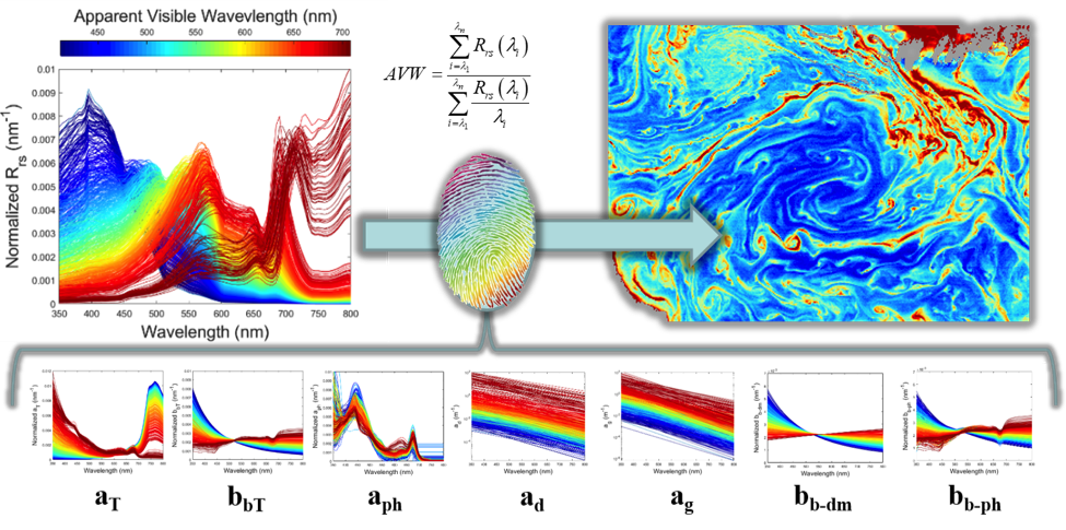
Here, 720 synthetic Rrs(λ) spectra, as well as the corresponding inherent optical property subcomponents, are categorized according the Apparent Visible Wavelength (AVW), a one-dimensional geophysical metric related to spectral shape. Notably, the output is gradational, not incremental, thus it behaves more like a dynamic ocean property, as demonstrated from a mapped image of hyperspectral-equivalent AVW derived from MODIS-Aqua in the Arabian Sea (upper right). The dimensionality reduction of spectral information offers a robust and user-friendly means to describe and analyze unique spectral information in terms of spatial/temporal trends and variability.
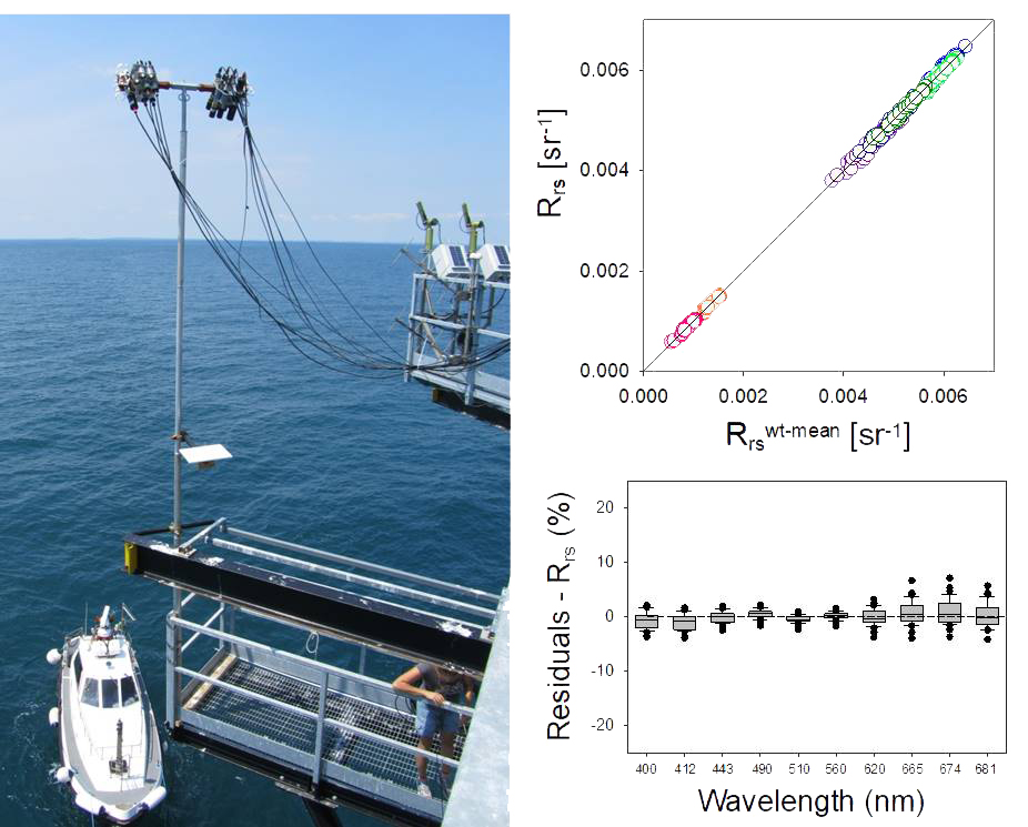 In another new publication, Tilstone et al. (2020) conducted a field intercomparison at the Acqua Alta Oceanographic Tower (AAOT) in the northern Adriatic Sea, from 9 to 19 July 2018 to assess differences in the accuracy of ten in- and above-water radiometer measurements used for the validation of ocean colour products. For downwelling irradiance (Ed), there was generally good agreement between sensors with differences of <6% for most of the sensors over the spectral range 400 – 665 nm. For sky radiance (Lsky), the spectrally averaged difference between optical systems was <2.5% with a root mean square error (RMS) <0.01 mWm−2 nm−1 sr−1. For total above-water upwelling radiance (Lt), the difference was <3.5% with an RMS <0.009 mWm−2 nm−1 sr−1. For remote-sensing reflectance (Rrs), the differences between above-water were <3.5% and <1.5% at 443 and 560 nm and <5% at 665 nm. Compared to AERONET-OC SeaPRiSM the difference to the above-water systems was 4.8%, and for the in-water systems it was 11.8%. Differences between the in-water and above-water systems arise from differences in spatial and temporal sampling and extrapolating the in-water data from depth to the subsurface. The differences between above-water systems mainly arose from differences in cosine response and FOV between and to a lesser extent sensors, and the Fresnel reflectance value used, and whether or not an NIR correction was applied at the data processing stage.
Stroming et al (2020) recently presented an impact assessment framework to characterize the socioeconomic benefits of satellite remote sensing for detecting cyanobacterial harmful algal blooms (cyanoHAB) and managing recreational advisories at freshwater lakes. They applied this framework to estimate the socioeconomic benefits of satellite data that were used to manage a 2017 cyanoHAB event in Utah Lake. CyanoHAB events on Utah Lake can pose health risks to people who interact with the blooms through recreation. They found that the availability of satellite data yielded socioeconomic benefits by improving human health outcomes valued at approximately $370,000, though a sensitivity analysis reveals that this central estimate can vary significantly ($55,000 – $1,057,000 in benefits) as a result of different assumptions regarding the time delay in posting a recreational advisory, the number of people exposed to the cyanoHAB, the number of people who experience gastrointestinal symptoms, and the cost per case of illness.
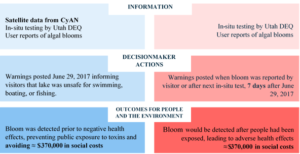
Impact assessment framework for 2017 Utah Lake cyanoHAB event
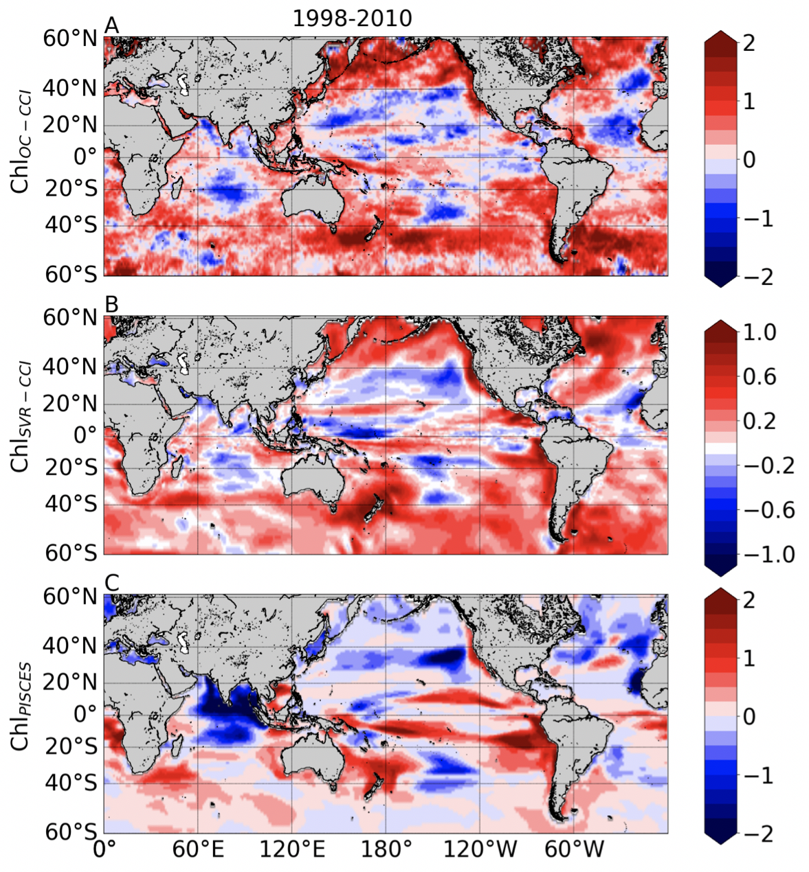
Liner trends (% per year) calculated over 1998-2010 from the monthly A) ln(ChlOC-CCI), B) ln(ChlSVC-CCI) and C) ln(ChlPICES). Note different scale for B.
Martinez et al. (2020) investigated the ability of a machine learning approach (a non-linear statistical approach based on Support Vector Regression, hereafter SVR) to reconstruct global spatio-temporal Chl variations from selected surface oceanic and atmospheric physical parameters. Two decades of satellite observations are still too short to provide a comprehensive description of Chl variations at decadal to multi-decadal timescales. With a limited training period (13 years), they first demonstrated that Chl variability derived from a 32-year global physical-biogeochemical simulation could successfully be reproduced with a SVR using the model surface variables as input parameters. They then applied the SVR to reconstruct satellite Chl observations using the physical predictors from the numerical model, and showed that the Chl reconstructed by this SVR more accurately reproduces some aspects of observed Chl variability and trends, compared to the model simulation. The SVR is able to reproduce the main modes of interannual Chl variations depicted by satellite observations in most regions, including the El Niño signature in the tropical Pacific and Indian Ocean. In stark contrast with the trends simulated by the biogeochemical model, it also accurately captures spatial patterns of Chl trends estimated by satellites data, with a Chl increase in most extratropical regions and a Chl decrease in the center of the subtropical gyres, although the amplitude of these trends are underestimated by half. Results from their SVR reconstruction over the entire period (1979-2010) also suggest that the Interdecadal Pacific Oscillation drives a significant part of decadal Chl variations in both the tropical Pacific and Indian Ocean. Overall, this study demonstrates that non-linear statistical reconstructions can be complementary tools to in situ and satellite observations as well as conventional physical-biogeochemical numerical simulations to reconstruct and investigate Chl decadal variability.
In another new publication, Soja-Woźniak et al. (2020) examined the effect of phytoplankton community size structure on remote-sensing reflectance and satellite Chl-a products of the OLCI instrument on board Sentinel-3 A. They found that large phytoplankton impact absorption and scattering less than small phytoplankton. Consequently, satellite Chl-a is underestimated in Case-1 waters dominated by large phytoplankton, and in these waters, band-ratio algorithms tend to retrieve Chl-a of small phytoplankton only. A similar underprediction was found in Chl-a concentration calculated with the band-ratio OC4Me algorithm using in situ and IOP-calculated reflectance. Excluding Chl-a associated with large-sized phytoplankton reduced the bias in the OC4Me from −31% to −0.1%. The large cells absorbed and scattered less per unit chlorophyll resulting in a smaller impact on the reflectance, and therefore are less detectable by remotely-sensed, band-ratio-based, Chl-a algorithms than small cells.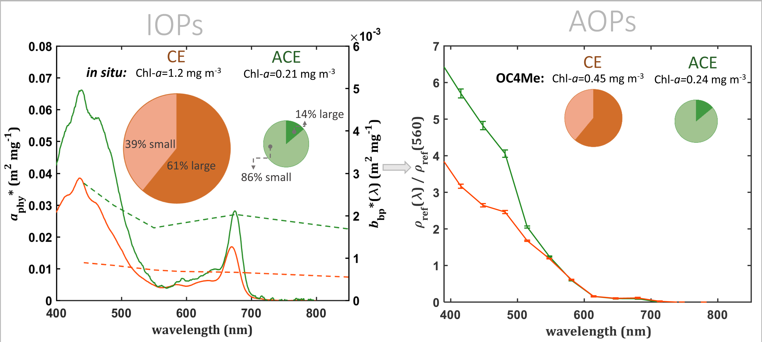
![]() Lastly, Craig et al. (2020) developed a synthetic, hyperspectral, top-of-atmosphere (TOA) dataset for PACE ocean colour algorithm development. This synthetic dataset was created to provide a measurement error-free hyperspectral (350-800 nm, 5 nm resolution) dataset as part of research performed by the first NASA PACE Science Team. A synthetic dataset of sea surface and TOA radiances was constructed by a Coupled Ocean Atmosphere Radiative Transfer (COART) model (Du and Lee, 2014) based on the SBDART (Santa Barbara DISORT Atmospheric Radiative Transfer) code (Ricchiazzi et al. 1998), with ocean contribution simulated by Hydrolight (Mobley, 2008). Water-leaving radiance (Lw) was forward modelled with Hydrolight with a solar zenith angle of 30°, cloudless sky, a sea surface state corresponding to a wind speed of 5 m/s, and realistic concentrations of optically active water constituents. The Hydrolight component of the model was constrained using inherent optical properties whose dynamic ranges and spectral qualities were based on real, in situ data acquired from the NASA SeaBASS dataset (https://seabass.gsfc.nasa.gov/) and that represent realistic in situ conditions. Certain characteristics of the IOPs were semi-randomly modelled based on principles outlined in IOCCG Report No.5 (2006) and summarised in an accompanying pdf document. Atmospheric conditions were simulated by coupling the water-leaving radiances to an atmosphere with and without absorbing gases, and with an aerosol optical depth that varied between 0.1-0.8. The dataset and supporting documentation can be accessed at: https://doi.org/10.1594/PANGAEA.915747.
Lastly, Craig et al. (2020) developed a synthetic, hyperspectral, top-of-atmosphere (TOA) dataset for PACE ocean colour algorithm development. This synthetic dataset was created to provide a measurement error-free hyperspectral (350-800 nm, 5 nm resolution) dataset as part of research performed by the first NASA PACE Science Team. A synthetic dataset of sea surface and TOA radiances was constructed by a Coupled Ocean Atmosphere Radiative Transfer (COART) model (Du and Lee, 2014) based on the SBDART (Santa Barbara DISORT Atmospheric Radiative Transfer) code (Ricchiazzi et al. 1998), with ocean contribution simulated by Hydrolight (Mobley, 2008). Water-leaving radiance (Lw) was forward modelled with Hydrolight with a solar zenith angle of 30°, cloudless sky, a sea surface state corresponding to a wind speed of 5 m/s, and realistic concentrations of optically active water constituents. The Hydrolight component of the model was constrained using inherent optical properties whose dynamic ranges and spectral qualities were based on real, in situ data acquired from the NASA SeaBASS dataset (https://seabass.gsfc.nasa.gov/) and that represent realistic in situ conditions. Certain characteristics of the IOPs were semi-randomly modelled based on principles outlined in IOCCG Report No.5 (2006) and summarised in an accompanying pdf document. Atmospheric conditions were simulated by coupling the water-leaving radiances to an atmosphere with and without absorbing gases, and with an aerosol optical depth that varied between 0.1-0.8. The dataset and supporting documentation can be accessed at: https://doi.org/10.1594/PANGAEA.915747.
Employment Opportunities
Several new positions have been added to Employment Opportunities on the IOCCG website including:
- Two Earth Observation scientist positions at PML (UK)
- Remote Sensing scientist- ocean colour at EUMETSAT (Germany)
- Researcher position at NIVA (Norway)
- Service Engineer at Sequoia Scientific (USA)
- Several post-doctoral positions at University of Southern Mississippi (USA), University of Victoria (Canada), Bedford Institute of Oceanography (Canada), the Royal Netherlands Institute for Sea Research (Netherlands) and Ghent University (Belgium).
For more information on these and other positions see http://ioccg.org/resources/employment-opportunities/
