This IOCCG news bulletin contains a summary of the latest news from the IOCCG and its sponsoring agencies, as well as the broader ocean colour community. If you would like to include a news item in the next IOCCG news bulletin, please contact the IOCCG Project Coordinator, Dr. Venetia Stuart (vstuart@ioccg.org). If you are having trouble receiving emails from IOCCG on your network, please see instructions on how to Whitelist “Campaign Monitor” (the IOCCG email marketing platform). Please also Whitelist vstuart@ioccg.org and ioccg@ioccg.org (especially important for subscribers with Gmail accounts – also check your SPAM folder).
IOCCG News
New IOCCG Report on Harmful Algal Blooms
 Ocean colour radiometry offers considerable potential for the observation of harmful algal blooms (HABs). Several years ago the IOCCG established a working group on this topic (chaired by Stewart Bernard, SANSA) in conjunction with the GEOHAB international science programme (now GlobalHAB ). We are happy to announce that the report on this topic is in the final stages of publication. The report contains various case studies of remote sensing of harmful algal blooms in coastal and inland waters, including cyanobacterial blooms, toxic diatom and dinoflagellate blooms, fish-killing blooms and other harmful high biomass / ecologically disruptive algal blooms. The advantages and limitations of using satellite ocean colour radiometry for HAB observations are addressed, including the inherent challenges of remote sensing in high biomass, optically complex, coastal and small inland water bodies. The report concludes with chapters on the transition from HAB ocean colour research to operational HAB monitoring systems, as well as future perspectives and recommendations.
Once the report has been published (likely within 3-4 months), digital copies will be made available on the IOCCG website at https://ioccg.org/what-we-do/ioccg-publications/ioccg-reports/. Hard copies will also be printed, courtesy of the State Key Laboratory of Satellite Ocean Environment Dynamics, Second Institute of Oceanography, Ministry of Natural Resources, China, which is gratefully acknowledged. If you would like to receive a hardcopy of this report, please complete the IOCCG Report Request Form. A limited number of reports will be printed, so please submit your request in advance (hard copies may not be available at a later date). Also please use a mailing address that will still be valid in several months’ time.
GeoKompsat- 2B GOCI-II Data to be Distributed Soon

GOCI- II RGB image captured on January 1, 2021 (Slot 8).
The second Geostationary Ocean Color Imager (GOCI-II) onboard the GEO-KOMPSAT-2B satellite was successfully launched by South Korea on 19 February 2020. The GOCI-II sensor focuses on the succession and expansion of the original GOCI mission (launched 26 June 2010) and provides enhanced spatial and spectral resolution. GOCI-II can provide images around the Korean peninsula (Local Area, LA) 10 times a day with 250 m GSD and 13 spectral bands. GOCI-II can also provide images for the hemisphere (Full Disk, FD) each day with 250 m GSD.
The Korea Institute of Ocean Science and Technology (KIOST) has been busy testing and calibrating the initial phase of GOCI-II Level-2 algorithms since October 2020, so they are now preparing for the distribution of GOCI-II Level-1b and Level-2 data. The National Ocean Satellite Center (NOSC) of the Korea Hydrographic and Oceanographic Agency (KHOA) plans to start distributing the GOCI-II Level-1b and Level-2 data (in order of preparation) from the end of January 2021 onward (http://www.khoa.go.kr/nosc/intro/noticeList.do – website currently available in Korean only). The GOCI-II toolbox plug-in, based on SNAP (see https://sciwatch.kiost.ac.kr/handle/2020.kiost/22635), provides GOCI-II data searching, visualization and analysis (for all systems), as well as data processing (Linux only) from Level-1b to Level-2.

Images of the Korean Peninsual captured by GOCI (left) and GOCI-II (middle) on 23 March 2020 at the same time (13:15). Full disk image (right) from GOCI-II captured on 14 March 2020.
News from NOAA
Ocean Color Instrument Recommended for NOAA’s Next Generation Geostationary Mission
NOAA’s Geostationary Extended Observations (GeoXO) satellite system is the ground-breaking mission that will advance Earth observations from geostationary orbit. GeoXO will supply vital information to address major environmental challenges of the future in support of U.S. weather, ocean and climate operations. A GeoXO ocean color imager will support the NOAA missions of Supporting Healthy Oceans, Resilient Coasts, and Climate Science by providing observations of ocean biology, chemistry, and ecology to assess ocean productivity, ecosystem change, coast/inland water quality, and hazards like harmful algal blooms. For a more in-depth story, see the 11 January 2021 article in Space News.
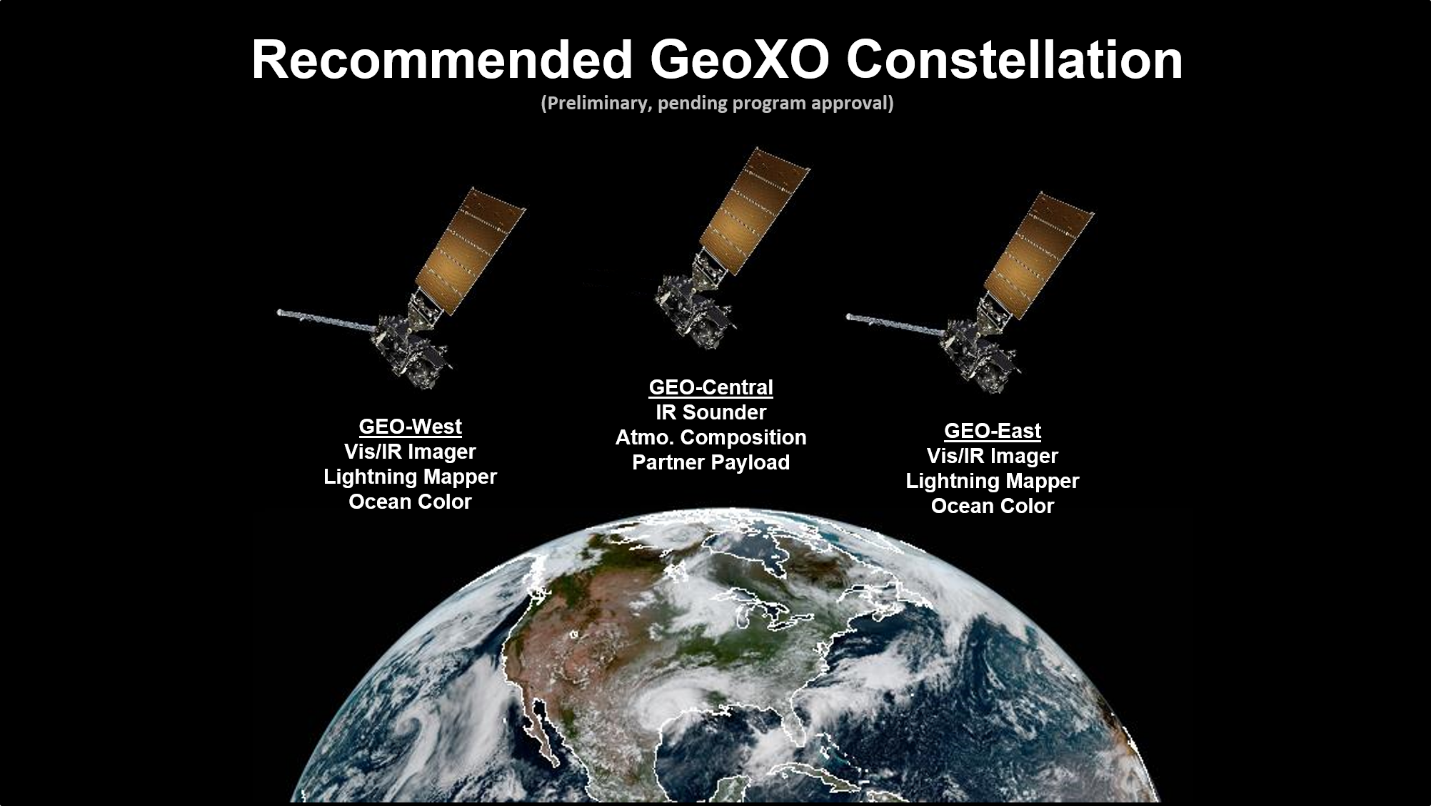
Figure from GEO-XO website: NOAA is currently planning, pending approval, a three-satellite GeoXO operational constellation with ocean colour instruments on spacecraft in the GOES-East and GOES-West positions. Credit: NOAA National Environmental Satellite, Data and Information Service (click to enlarge).
United Nations Sustainable Development Goals Uses NOAA VIIRS Ocean Color Data Product
![]() The NOAA Ocean Color VIIRS chlorophyll anomaly product (Wang et al., 2021; see New Publications below) is being used in an indicator product for the United Nations Sustainable Development Goals 14.1.1a, “Index of coastal eutrophication”. The NOAA ocean color team routinely produces the anomaly product. NOAA CoastWatch serves the anomaly product and collaborates with a technical team that includes participants from the United Nations, Geo Blue Planet, and ESRI as well as academic advisors which developed the specific UN indicator where information about trends in chlorophyll anomalies within a member country’s EEZ may be helpful in leading to the identification and potential mitigation of eutrophication causes.
The NOAA Ocean Color VIIRS chlorophyll anomaly product (Wang et al., 2021; see New Publications below) is being used in an indicator product for the United Nations Sustainable Development Goals 14.1.1a, “Index of coastal eutrophication”. The NOAA ocean color team routinely produces the anomaly product. NOAA CoastWatch serves the anomaly product and collaborates with a technical team that includes participants from the United Nations, Geo Blue Planet, and ESRI as well as academic advisors which developed the specific UN indicator where information about trends in chlorophyll anomalies within a member country’s EEZ may be helpful in leading to the identification and potential mitigation of eutrophication causes.
Second International Operational Satellite Oceanography Symposium
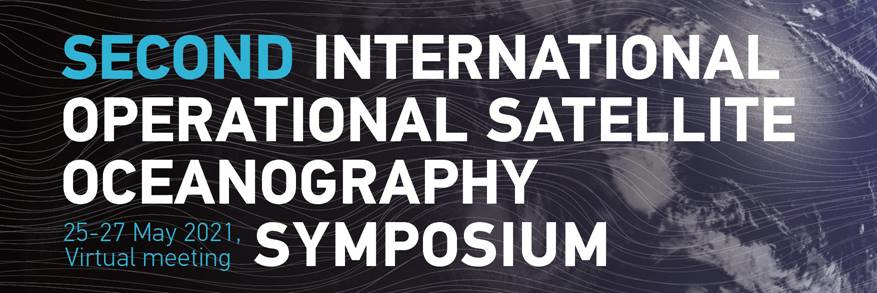
Reminder that registration and abstracts have been called for the Second International Operational Satellite Oceanography Symposium (OSO) which will be held virtually, 25-27 May 2021, with a bonus training day on 28 May 2021. This symposium is co-hosted by EUMETSAT and NOAA.
News from EUMETSAT
![]()
Registration for the upcoming online course: Copernicus Marine Data Stream for Operational Services – Ocean Applications is now open (deadline to register 2 March 2021). The course will be conducted online from 19 April – 7 May 2021. Attendees should anticipate putting in 1-2 hours of self-paced learning each day (excluding weekends) for the duration of this course.
The purpose of this EUMETSAT Copernicus Marine Data Stream (CMDS) training workshop is to share knowledge, skills, resources and code so that attendees are independently able to access and process Sentinel-3 data for their marine workflows and applications. This training is aimed at those working in the operational marine sector and government agencies who are interested in working with satellite-based ocean observation data for marine applications. Please note that this does not include marine weather forecasting (meteorology).
Registration page: https://training.eumetsat.int/mod/questionnaire/view.php?id=13998 (for full access to the site, you first need to create an account). Further details on the course can be found in the course information sheet.
New CO2COAST Project
![]() The CO2COAST project will analyze the spatio-temporal variability of pCO2 and air-sea flux of CO2 over the global coastal ocean over the past two decades, using a satellite approach. This 4-year project, funded by the French National Agency of Research (ANR), will be headed by PI Hubert Loisel of the Université du Littoral – Côte d’Opale (LOG and A2DM labs).
The CO2COAST project will analyze the spatio-temporal variability of pCO2 and air-sea flux of CO2 over the global coastal ocean over the past two decades, using a satellite approach. This 4-year project, funded by the French National Agency of Research (ANR), will be headed by PI Hubert Loisel of the Université du Littoral – Côte d’Opale (LOG and A2DM labs).
Due to the relatively limited spatio-temporal coverage of in situ data, uncertainties in coastal carbon fluxes are such that the CO2 flux in the coastal margins remains a poorly constrained term in global carbon budgets. Satellite remote sensing allows for the collection of various physical and biological parameters at global scales, at different temporal resolutions not accessible from other observation methods. In this context, the objectives of CO2COAST are to estimate the global coastal waters CO2 flux from satellite observations at high spatial resolution (1-km2), and assess and analyze its seasonal and inter-annual variability, as well as the trends over the 25 last years. This unique data set will allow researchers to scrupulously analyze the controversial contribution of estuaries and the coastal shelf areas respectively. This methodology is based on the combination of the in situ SOCAT data set of fugacity of CO2, ocean colour radiometry (OCR) and sea surface temperature (SST) observations using a neural net (NN) algorithm coupled with a water class-based approach. Several PhD and postdoc positions will be funded through CO2COAST, which will start in March 2021.
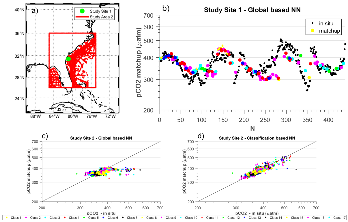
(a) Map of the pCO2 in situ data points available for the match-up exercise around the eastern US coast (red). The green dot represents the location of the time series used in b). (b) temporal evolution of pCO2w measured in situ and estimated from the preliminary global-based NN-algorithm from Feb 2005 to Aug 2009, indicating that improvements need to be made for some optical water classes (OWC). Comparison of pCO2 measured in situ and estimated from (c) the preliminary global NN-algorithm or (d) the preliminary classification-based NN-algorithm over the study 2. Each colour/symbol stands for a given OWC (click to enlarge).
Hyperspectral Imaging and Sounding of the Environment (HISE) Meeting
![]()
The Optical Society’s (OSA) 2021 Hyperspectral Imaging and Sounding of the Environment (HISE) meeting will take place on 19 – 23 July 2021 in Vancouver, British Columbia, Canada. The meeting brings together researchers and industry leaders in the field of hyperspectral remote sensing of terrestrial, coastal, oceanic, and atmospheric phenomena and industrial processes. You can find more information about the meeting, the topic categories, and confirmed invited speakers at http://www.osa.org/HISE.
We solicit presentations on recent advances in all aspects of active and passive hyperspectral remote sensing of coastal and inland aquatic systems, including, but not limited to, instrumentation, image processing, information extraction through artificial intelligence and machine learning techniques, radiative transfer modeling, atmospheric correction, algorithm development, data product retrieval, disaster response, and environmental monitoring.
HISE will be held as one of 10 topical meetings related to optical imaging and sensing in this four-day congress, providing ample opportunities for networking and learning. Confirmed keynote speakers focused on aquatic remote sensing include Dr. Antonio Mannino, Dr. Ved Chirayath, Dr. Erin Hestir, and Dr. Nima Pahlevan. Confirmed invited speakers thus far include Dr. Joe Ortiz, Dr. Claudia Giardino, and Dr. Morgaine McKibbens.
The meeting will be held in a hybrid format, consisting of virtual and in-person (contingent on local rules and travel restrictions during the meeting dates) presentations. The inability to travel will not be a hindrance to participating and presenting at the meeting.
The deadline for submitting the abstract and summary paper is 02 March 2021. You can find more information about abstract submission at https://www.osa.org/en-us/meetings/osa_meetings/optical_sensors_and_sensing_congress/submit_papers/
We look forward to receiving an excellent collection of abstracts from the aquatic remote sensing community.
Regards,
Michelle Gierach (michelle.gierach@jpl.nasa.gov), Wes Moses (wesley.moses@nrl.navy.mil), Andrea Vander Woude (andrea.vanderwoude@noaa.gov), and Emmanuel (Emmanuel.Devred@dfo-mpo.gc.ca) on behalf of the 2021 HISE Program Committee.
The Oceanography Society 2020–2021 Honors Recipients
![]()
Emmanuel Boss: Congratulations to IOCCG Committee member, Emmanuel Boss for his contributions to, and his leadership in, ocean optics and its use in mapping biogeochemical processes in the ocean, for his inspirational teaching, and for his unwavering commitment to service and mentoring young scientists.
Edward R. Urban Jr: For over 30 years of outstanding and sustained contributions to ocean sciences through extraordinary service and leadership in the US and international oceanographic research community.
Dawn Wright: For leadership in the development of data science for the oceans, focusing on data quality, open science, and the development of spatial analytic tools to define the oceanic realm.
Special Issues in Remote Sensing
![]() There are two upcoming Special Issues in the journal Remote Sensing. The first is on the topic “From Observations to End-User Engagement: Operational Applications of Remote Sensing to Inland and Coastal Waters”, edited by Mhd. Suhyb Salama (University of Twente) and Steef Peters (WaterInsight). With the operational data streams from the Sentinel missions and the Copernicus program of the European Space Agency and the maturity of emerging observations from miniature satellites and unmanned aerial vehicles, remote sensing technology is moving towards long-term sustainable data streaming, forming the basis for its operational use. In particular, setting up remote sensing (RS) services for inland and coastal waters provides an instrument for early warning and mitigation on extended spatiotemporal scales. However, the added value of any RS-based service is determined, primarily, by its uptake by the end-users, e.g., managers, governmental organizations, private companies, and/or the general public. With your original contributions, this Special Issue will answer vital questions on the added values of observation and end-user engagement. This special issue is now open for submission (deadline for manuscript submissions: 30 August 2021). Click here for further information as well as manuscript submission.
There are two upcoming Special Issues in the journal Remote Sensing. The first is on the topic “From Observations to End-User Engagement: Operational Applications of Remote Sensing to Inland and Coastal Waters”, edited by Mhd. Suhyb Salama (University of Twente) and Steef Peters (WaterInsight). With the operational data streams from the Sentinel missions and the Copernicus program of the European Space Agency and the maturity of emerging observations from miniature satellites and unmanned aerial vehicles, remote sensing technology is moving towards long-term sustainable data streaming, forming the basis for its operational use. In particular, setting up remote sensing (RS) services for inland and coastal waters provides an instrument for early warning and mitigation on extended spatiotemporal scales. However, the added value of any RS-based service is determined, primarily, by its uptake by the end-users, e.g., managers, governmental organizations, private companies, and/or the general public. With your original contributions, this Special Issue will answer vital questions on the added values of observation and end-user engagement. This special issue is now open for submission (deadline for manuscript submissions: 30 August 2021). Click here for further information as well as manuscript submission.
The second Special Issue is entitled “Big Earth Data and Remote Sensing in Coastal Environments“, edited by Cuizhen (Susan) Wang, Li Zhang and Deepak R. Mishra. Coastal environments are steadily subjected to natural and anthropogenic stresses such as hurricanes, floods, sea level rise and coastal development. Big Earth Data is a new frontier in earth and information sciences to study our living planet from excessive earth observations. This special issue solicits papers highlighting its recent advancements with a focus on addressing various environmental problems by means of innovative data collection, processing, and analytical solutions in coastal zone. You are invited to contribute a research paper or review. This special issue is now open for submission (deadline for manuscript submissions: 31 October 2021). More details about the Special Issue are available here.
Workshops & Webinars
![]() View the GEO AquaWatch webinar “Towards Macroscale Application of Inland Water Remote Sensing” by Simon Topp, as well as upcoming AquaWatch Workshop Project Updates Lightning Rounds (March 24, 2021 1:00– 3:00 PM GMT).
View the GEO AquaWatch webinar “Towards Macroscale Application of Inland Water Remote Sensing” by Simon Topp, as well as upcoming AquaWatch Workshop Project Updates Lightning Rounds (March 24, 2021 1:00– 3:00 PM GMT).
![]() GEO Blue Planet held a workshop series online on Earth Observations for Tuna Fisheries Management throughout November – December 2020. Use the above link to access PowerPoint as well as video recordings from this workshop series.
GEO Blue Planet held a workshop series online on Earth Observations for Tuna Fisheries Management throughout November – December 2020. Use the above link to access PowerPoint as well as video recordings from this workshop series.
![]() As part of the NANO Webinar Series, Dr. Anna Rumyantseva (Hitachi Vantara, UK) presented a talk on “The role of machine learning in tackling climate emergency“. Past Webinars can be viewed here.
As part of the NANO Webinar Series, Dr. Anna Rumyantseva (Hitachi Vantara, UK) presented a talk on “The role of machine learning in tackling climate emergency“. Past Webinars can be viewed here.
![]() If you did not attend the NASA ARSET training opportunity on “Hyperspectral Data for Land and Coastal Systems” you can still view the presentation slides here.
If you did not attend the NASA ARSET training opportunity on “Hyperspectral Data for Land and Coastal Systems” you can still view the presentation slides here.
![]() The Atlantic International Research Centre holds a regular Networking Fridays 2021 Webinar Series, including a Thematic Special Session on Nanosatellites. Videos of past sessions are available on their YouTube Channel
The Atlantic International Research Centre holds a regular Networking Fridays 2021 Webinar Series, including a Thematic Special Session on Nanosatellites. Videos of past sessions are available on their YouTube Channel
![]() The Canadian Network on Coastal, Oceans and Lake Optics Remote sensing (NetColor) will be holding a series of virtual sessions every Wednesday of March 2021, between 1 and 3 PM (EST) to share projects, results or techniques relevant to Canadian ocean colour researchers.
The Canadian Network on Coastal, Oceans and Lake Optics Remote sensing (NetColor) will be holding a series of virtual sessions every Wednesday of March 2021, between 1 and 3 PM (EST) to share projects, results or techniques relevant to Canadian ocean colour researchers.
In Memoriam
 It is with deep sadness that we report on the passing of former IOCCG Committee member, Dr. Oleg Kopelevich. He was head of the Ocean Optics Laboratory at the P. P. Shirshov Institute of Oceanology, Russia, and served on the IOCCG Committee from 1997 – 2001. He was a very active member of the IOCCG Committee and we had the pleasure of working with him for many years. He also co-chaired the Natural Water Optics Conference, held every two years in St. Petersburg, and was the author and co-author of more than 130 scientific papers and 6 monographs (click here for further information on his research career). On behalf of the IOCCG Committee we extend our deepest condolences to his family, colleagues and friends.
New Publications
A new publication by Holtrop et al. (2020) examines the vibrational modes of water to predict spectral niches for photosynthesis in lakes and oceans. Photosynthetic organisms have evolved a whole suite of different pigments to harvest the energy from the sun. But why did these different pigments evolve, and why is there not a single pigment that is optimal under all light conditions? The answer is hidden in the tiny vibrations of the water molecule. The stretching and bending vibrations between the oxygen and hydrogen atoms in the H2O molecules lead to increased absorption of light energy at specific wavebands. Light absorption by water molecules at these specific wavelengths creates large gaps in the underwater light spectrum. These gaps define a series of distinct underwater colours called ‘spectral niches’ that are exploited by the different pigments that we find in photosynthetic organisms.
Radiative transfer simulations show that the vibrational modes of water molecules cause light energy to remain in the violet, blue, green, orange and red parts of the visible spectrum. The model simulations are combined with ESA’s OC CCI dataset to predict the global geographical distributions of these five spectral niches. In-situ measurements, including samples taken during the TARA oceans expedition, show that the predictions agree remarkably well with the observed biogeographical distributions of the photosynthetic pigments. Further advancement of methods to remotely detect spectral niches could aid in the development of new algorithms to retrieve phytoplankton community composition from ocean colour data.

Global distribution of three out of the five spectral niches. The geographical maps show the relative availability of the violet, blue and green spectral niches at the euphotic depth. Absorption coefficients of dissolved and detrital matter at 443 nm obtained from ESA’s OC CCI dataset served as input for radiative transfer simulations to predict the relative availability of the spectral niches.
In another new publication Wang et al. (2021) demonstrate how to extend satellite ocean colour remote sensing to the near-blue ultraviolet bands. Ultraviolet (UV) radiation has a profound impact on marine life, but historically and even currently, most ocean colour satellites cannot provide radiance measurements in the UV, and thus UV penetration, in the global ocean. The authors developed a system based on deep learning (termed UVISRdl), to estimate remote sensing reflectance (Rrs) at 360, 380, and 400 nm (collectively termed the near-blue UV bands, nbUV) from Rrs in the visible bands that are obtained by ocean colour satellites. This system was tested using both synthetic and field-measured data, with the resultant coefficient of determination between estimated UVISRdl and known Rrs(nbUV) close to 1.0, and the bias close to 0. These results indicate excellent predictability of Rrs(nbUV) from Rrs (visible) via UVISRdl. The system was further applied to VIIRS (the Visible Infrared Imaging Radiometer Suite) data with the estimated Rrs(nbUV) evaluated using matchup field measurements. A mean absolute relative difference (MARD) of ~14% was obtained at 360 nm for oceanic waters and ~50% for coastal waters. These results are equivalent to those reported in the literature for satellite Rrs (visible) in oceanic and coastal waters. Examples of the global distribution of Rrs(nbUV), and subsequently the diffuse attenuation coefficient at the nbUV bands (Kd(nbUV)), were generated after applying UVISRdl to Rrs (visible) from the VIIRS data. Analyses between Kd(360), Kd(380) and Kd(490) of the global ocean indicate that the applicability of the “Case 1” concept is further limited in the UV bands.
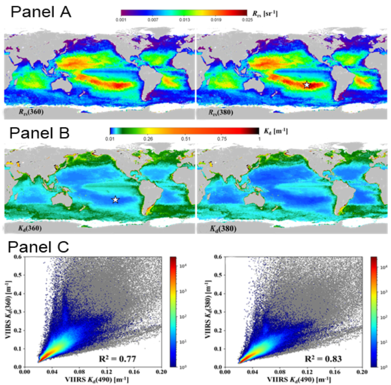
Panel A: Global distribution of Rrs(360) and Rrs(380); Panel B: Global distribution of Kd(360) and Kd(380); Panel C: Relationship between Kd(360), Kd(380) and Kd(490) of the global ocean.
Lastly, Wang et al. (2021) describe the first-ever, near-real-time, global daily Chl-a anomaly products that can be used to detect and identify algae blooms from satellite ocean color measurements, such as those from VIIRS. Specifically, the production of the two Chl-a anomaly products, one for the Chl-a anomaly in difference and another for the Chl-a anomaly ratio (or in its relative difference) compared to the 61-day Chl-a median value from the previous time period (as a Chl-a reference), has been implemented in the daily global NRT satellite data processing. These two Chl-a anomaly products represent the global ocean and coastal/inland water Chl-a abnormal condition for a given location and can provide more complete characteristics for the daily phytoplankton (or algae) biomass status by comparing to the normal condition. Detailed satellite Chl-a anomaly algorithms, the implementation of the algorithms in the routine satellite data processing, and the global data processing procedure are described and discussed. In addition, the authors provide several specific examples from the VIIRS-measured global daily Chl-a anomaly products to demonstrate various applications in the detection of algae blooms, including the harmful algal blooms (HABs), in various ocean and coastal/inland waters. Some quantitative seasonal and interannual evaluations and characterizations of Chl-a anomalies over global oceans and several coastal/inland waters are also provided and discussed.
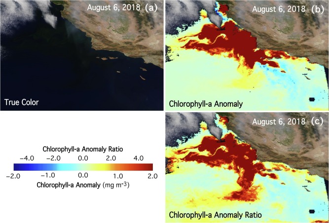
VIIRS-NOAA-20-measured (a) true color image, (b) ΔChl-a, and (c) ΔrChl-a data acquired on August 6, 2018, over the coast of California.
Employment Opportunities
Several new positions have been added to Employment Opportunities on the IOCCG website including:
- Optics Research Assistant for NASA’s Ocean Ecology Lab (USA)
- Software Engineer position at NASA GSFC (USA)
- Post-doctoral position at NOAA’s Pacific Marine Environmental Laboratory (USA)
- Post-doctoral position at Khalifa University, Abu Dhabi (UAE)
- Post-doctoral position at Helmholtz-Zentrum Geesthacht (Germany)
- Post-doctoral position at City University of New York (USA)
- Post-Doctoral position and 2 PhD scholarships at the Remote Sensing and Satellite Research Group (RSSRG), Curtin University (Western Australia)
- PhD studentship at the University of Stirling (UK)
For more information on these and other positions see http://ioccg.org/resources/employment-opportunities/.
