IOCCG News
2020 Summer Lecture Series
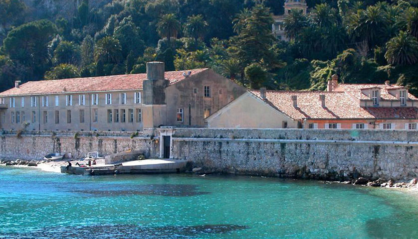 The dates for the next IOCCG Summer Lecture Series (SLS) have been finalized! SLS-2020 is scheduled to take place from 22 June – 3 July 2020 at the Laboratoire d’Océanographie de Villefranche (France), which is part of the IMEV (Institut de la Mer, de Villefranche), and hosts the Marine Optics and Remote Sensing group (MORS, www.obs-vlfr.fr/LOV/OMT/).
This training course is dedicated to high-level training in the fundamentals of ocean optics, bio-optics and ocean colour remote sensing. Several prominent ocean colour research scientists will be invited to lecture on cutting edge research focusing on current critical issues in ocean colour science. Interactive discussion sessions will explore various hot topics and will also allow students the opportunity to discuss their own research with leaders in the field. Several practical laboratory sessions will help students understand absorption, scattering and the colour of the ocean, and will also demonstrate how to collect high-quality in situ data and interpret the measurements.
 Students will have access to shared accommodation in the new “Jules Barrois” accommodation building at LOV, replacing the historic Galériens de la Vieille Forge (built by the Duke of Savoy in the 18th century).
Further information about the course can be found on the SLS-2020 website at https://ioccg.org/what-we-do/training-and-education/ioccg-sls-2020/. Application for the course will open early in the New Year, and the application forms will be posted on this website.
IOCCG CDOM Protocols
A new protocol document entitled “Measurement Protocol of Absorption by Chromophoric Dissolved Organic Matter (CDOM) and Other Dissolved Materials” has been posted on the IOCCG website and is ready for community review for the next ~60 days. Your input is important! Please download this protocol document from the IOCCG website and submit your comments to cdom_comments@oceancolor.gsfc.nasa.gov before the deadline of 22 December 2019. Community feedback is essential to ensure that these protocols are accepted as the new international reference standards, and are adhered to by the entire ocean colour community.
Measuring light absorption by CDOM in situ is necessary for developing and validating current and future ocean colour algorithms. A CDOM Working Group has revised this section of the NASA ocean optics protocols (Mitchell et al. 2003) under the auspices of the IOCCG to reflect the development of new instrumentation and a greater understanding of the importance of CDOM and its distribution in coastal and open ocean waters over the past twenty years. The goal of the working group is to describe a set of procedures that will be adhered to by the scientific community for making CDOM absorption measurements that can be integrated into bio-optical databases, specifically of sufficient quality to develop and validate ocean colour algorithms/products and contribute to CDOM science. See IOCCG website at: https://ioccg.org/what-we-do/ioccg-publications/ for other protocols in the series.
Training Course on Ocean Colour Remote Sensing, China
The opening ceremony of Advanced Training Course on Ocean Colour Remote Sensing (2019) took place on 25 October 2019 at the Second Institute of Oceanography, Ministry of Natural Resources of the People’s Republic of China (SIO/MNR). Twenty trainees from seven countries (Bangladesh, China, Egypt, India, Indonesia, South Korea, and Thailand) participated in this 1-week course sponsored by IOCCG, the EC Copernicus Programme, EUMETSAT, the State Key Laboratory of Satellite Ocean Environment Dynamics (SOED/SIO/MNR, China), the National Satellite Ocean Application Service (NSOAS, China), and Zhejiang University (ZJU, China). The local organization committee was led by Dr. Yan Bai from the SIO/MNR.
The key objective of this training was to help early career scientists to download, analyze and visualize data from the EUMETSAT Copernicus Marine Data Stream as well as the Chinese HY-1C ocean colour mission (see agenda). Participants also learned how to use the Marine Satellite Data Online Analysis Platform SatCO2 (www.satco2.com) for environmental monitoring and scientific research, including water quality monitoring, red tide detection, and marine carbon cycling/climate change investigations. Read more…..
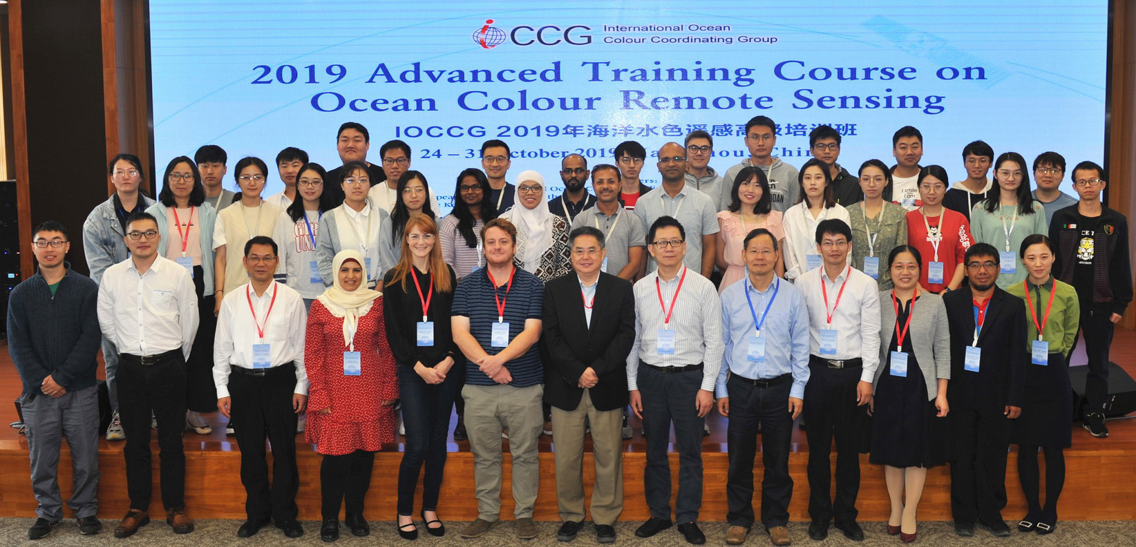
Participants and lecturers at the 2019 Advanced Training Course on Ocean Colour Remote Sensing
IOCCG-25 Meeting
The 25th annual IOCCG Committee meeting is scheduled to take place from 27-29 March 2020 in Tokyo, Japan. The meeting will be hosted by the Japan Aerospace Exploration Agency (JAXA) which is gratefully acknowledged. Several important issues will be addressed during the meeting, including implementation of the CEOS Ocean Colour Radiometry-Virtual Constellation (OCR-VC), a review of recommendations from the 2019 International Ocean Colour Science meeting, the status of the various IOCCG scientific working groups, and arrangements for the 2020 IOCCG Summer Lecture Series, to mention but a few.
News from JAXA
![]() Typhoon Hagibis made landfall in Japan on 12 October 2019, on the Izu Peninsula, just southwest of the capital city of Tokyo, bringing damaging winds, rough surf and torrential rain, causing flooding and mudslides. Clear skies the following day allowed JAXA’s GCOM-C satellite, carrying the SGLI ocean colour sensor to capture a striking view of the area around Tokyo. The true colour image (below left) shows the influx of river runoff from several rivers along the coast, discharging massive amounts of suspended sediment and organic matter into the ocean. The RBG image (below right) shows a one-hour change of water-leaving reflectance at 670 nm between Sentinel-3B/OLCI and GCOM-C/SGLI on 13 Oct 2019 (Red: SGLI, G and B: OLCI). Note that the observation time of OLCI is one-hour earlier that of SGLI. The spread of the sediment plumes is clearly visible within this timeframe.
Typhoon Hagibis made landfall in Japan on 12 October 2019, on the Izu Peninsula, just southwest of the capital city of Tokyo, bringing damaging winds, rough surf and torrential rain, causing flooding and mudslides. Clear skies the following day allowed JAXA’s GCOM-C satellite, carrying the SGLI ocean colour sensor to capture a striking view of the area around Tokyo. The true colour image (below left) shows the influx of river runoff from several rivers along the coast, discharging massive amounts of suspended sediment and organic matter into the ocean. The RBG image (below right) shows a one-hour change of water-leaving reflectance at 670 nm between Sentinel-3B/OLCI and GCOM-C/SGLI on 13 Oct 2019 (Red: SGLI, G and B: OLCI). Note that the observation time of OLCI is one-hour earlier that of SGLI. The spread of the sediment plumes is clearly visible within this timeframe.
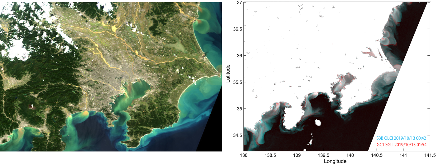
Left: True colour image of the area around Tokyo, Japan, captured on 13 October 2019, by the SLGI sensor on board GCOM-C. Right: one-hour change of water-leaving reflectance at 670 nm between Sentinel-3B/OLCI and GCOM-C/SGLI on 13 Oct 2019 (click to enlarge).
PACE Mission Milestones
 After passing a key review, the Plankton, Aerosol, Cloud, ocean Ecosystem (PACE) mission has received approval to move forward to Phase C, the critical design phase of the mission and the initiation of the flight build for the spacecraft and its three instruments. The PACE mission will monitor the health of Earth’s ocean ecosystems and atmosphere by studying phytoplankton as well as clouds and atmospheric aerosol particles above the water. NASA’s Goddard Space Flight Center (GSFC) leads the development of PACE, and is building the spacecraft and primary instrument, the Ocean Color Instrument (OCI).
The PACE mission recently selected two new System Vicarious Calibration projects to begin on 1 January 2020, and is in the midst of reviewing and selecting the next PACE Science and Applications Team. For more information on the PACE mission see: https://pace.oceansciences.org/news_more.htm?id=26.
News from NOAA
![]()
Short term chlorophyll anomaly products from the NOAA Ocean Colour Team are being adopted into methods for monitoring eutrophication, country by country, being developed through the United Nations Environment Program (UNEP) Sustainable Development Goal (SDG) 14.1.1. Recently, this SDG 14.1.1 indicator has been reclassified, which means a step closer to being implemented at the UN.
Chlorophyll biomass derived from the NOAA Multi-Sensor Level 1 to Level 2 (MSL12) ocean color enterprise processing is the basis for the VIIRS short term global chlorophyll anomaly (example of VIIRS SNPP shown in OCView in Figure below) that serves to monitor intra-seasonal phytoplankton blooms. This short term anomaly is based on the approach by Stumpf et al. (2010) used as an indicator for harmful algae blooms.
Several partners are working together to promote this eutrophication SDG 14.1.1, including Group on Earth Observations (GEO) Blue Planet; UNEP; corporate support by Esri; the NOAA ocean colour team; and the NOAA CoastWatch team.
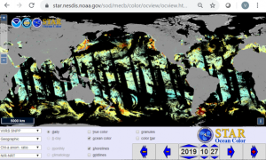
The NOAA VIIRS- SNPP MSL12 near real time chlorophyll anomaly ratio product shown in the OCView online viewing tool (Mikelsons and Wang, 2018). Click image to link to online image. Contact Dr. Emily Smail, Executive Director of GEO Blue Planet, for additional information on the UNEP eutrophication SDG project.
Special Issue “Advances in Marine Dissolved Organic Matter Dynamics”
 Marine dissolved organic matter (DOM) is one of the largest reservoirs of carbon on the planet and represents the main source of energy for heterotrophic prokaryotes. Containing as much carbon as the atmosphere and having a great ecological significance, DOM plays a key role in regulating air–sea CO2 exchanges and oceanic carbon sequestration that, ultimately, controls the Earth’s climate.
A special issue of the Journal of Marine Science and Engineering (JMSE) entitled “Advances in Marine Dissolved Organic Matter Dynamics” is now open for submission. The issue, edited by Chiara Santinelli and Emanuele Organelli, aims at publishing the most exciting research with respect to in-field, laboratory, biogeochemical modeling, and space-based studies that can help to understand where we are and how we go further in the knowledge of marine DOM. Multiplatform observations and studies on DOM–microbe interactions are welcomed. Investigations both at the global as well as at the regional scale are encouraged. For manuscript submission information see: www.mdpi.com/journal/jmse/special_issues/bz_marine_dissolved_organic.
2019 Fall AGU Awards
 Each year, AGU honors individuals for their outstanding achievements, contributions, and service to the Earth and space science community. AGU medals are the highest honors bestowed by the Union. The 2019 section awardees and named lecturers have been announced and will be celebrated at the 2019 Fall AGU meeting (9-13 December 2019, San Francisco, USA). IOCCG member, Paula Bontempi (NASA) and former member, Heidi Sosik (Woods Hole Oceanographic Institution), will receive awards in the Ocean Sciences Section. We wholeheartedly congratulate them both for these prestigious honors.
New Publications
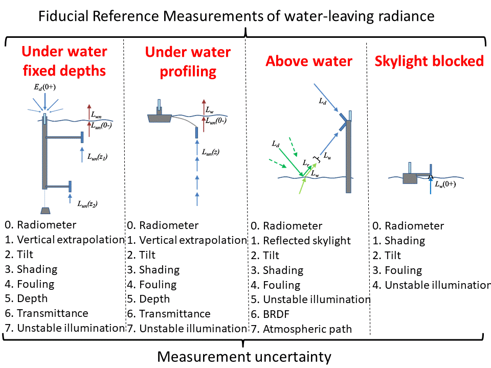
Two new publications by Ruddick and co-authors (2019) have been added to the IOCCG Ocean Colour Bibliography. The authors have prepared comprehensive reviews of the protocols for fiducial reference measurements (FRM) of, i) Water-Leaving Radiance and ii) Downwelling Irradiance for the validation of satellite remote sensing data over water. The measurement of water reflectance requires measurement of water-leaving radiance, as well as downwelling irradiance, just above the water.
Reproduced from Ruddick et al. (2019a), Remote Sens. 11(19), 2198; doi.org/10.3390/rs11192198/
For water-leaving radiance there are four generic families of methods, based on: (Lw1) underwater radiometry at fixed depths; or (Lw2) underwater radiometry with vertical profiling; or (Lw3) above-water radiometry with skyglint correction; or (Lw4) on-water radiometry with skylight blocked (see image on left).
Reproduced from Ruddick et al. (2019b), Remote Sens. 11(15), 1742; doi.org/10.3390/rs11151742
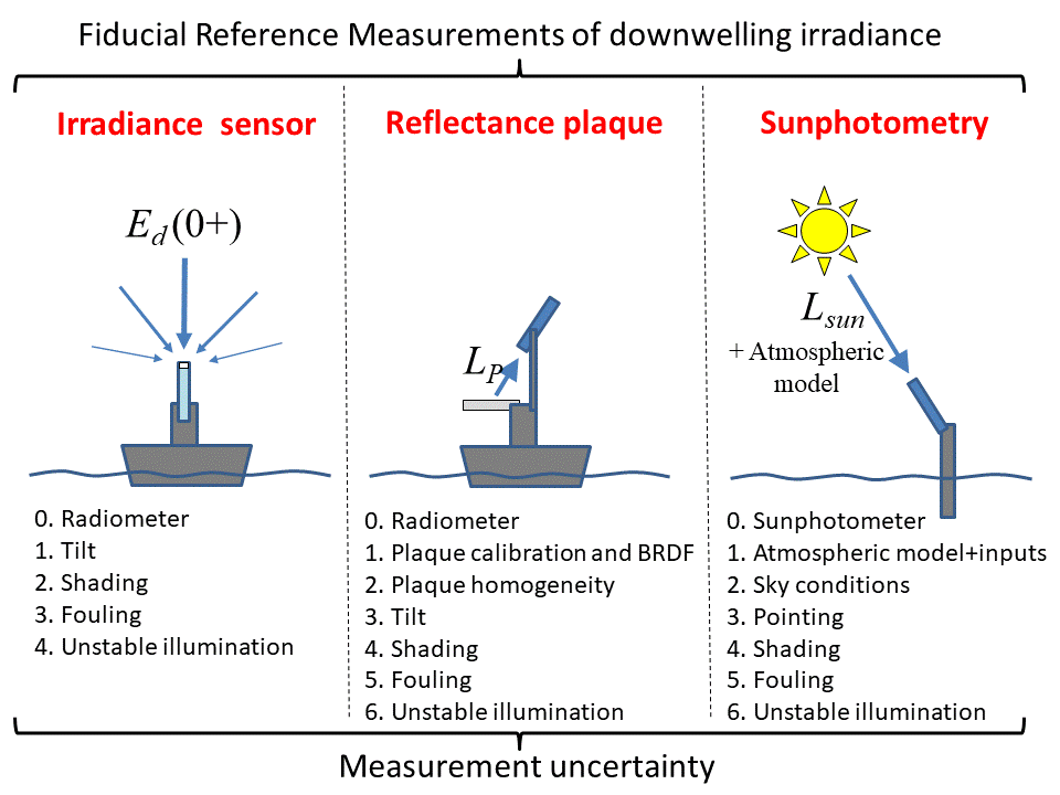
For downwelling radiance there are three generic families of method, using: (Ed1) an above-water upward-pointing irradiance sensor; (Ed2) an above-water downward-pointing radiance sensor and a reflective plaque; (Ed3) a Sun-pointing radiance sensor (sunphotometer) (see image on right). Each method is described generically in the new publications, with reference to the measurement equation, documented implementations, and the intra-method diversity of deployment platform and practice.
Ideal measurement conditions are stated, practical recommendations are provided on best practice, and guidelines for estimating the measurement uncertainty are provided for each protocol-related component of the measurement uncertainty budget. The state-of-the-art for the measurements of water-leaving radiance and downwelling irradiance are summarized and future perspectives are outlined. Key debates such as the use of reflectance plaques with calibrated or uncalibrated radiometers are presented, and the question of which water-leaving radiance measurement method is best adapted to various circumstances (water type, wavelength) is discussed.
In another new publication, Lee et al. (2019) examined the nature of optical products inverted semi-analytically from remote sensing reflectance (Rrs) of stratified waters. Inherently, Rrs represents total contributions in the upper water column, and a Rrs spectrum cannot reveal the vertical distribution of in-water constituents, but rather an “averaged” value will be retrieved. To interpret this average, Gordon and Clark (1980) proposed a weighted average for remotely sensed concentration of chlorophyll (Chl), which has been adopted by the community over the past four decades.
The inversion from a Rrs spectrum via analytical or empirical algorithms, however, involves multiple wavelengths, and is thus ambiguous on the selection of the wavelength for a weighted average. Lee et al. (2019) derived analytical expressions between inherent optical properties (IOPs) retrieved using semi-analytical algorithms (SAA) and the vertical profiles of IOPs. Some of the general features found for retrievals in stratified waters include:
- The classical weighting scheme for Chl of stratified waters is not applicable to optical products obtained from an SAA; further, SAA-derived backscattering (bb) and absorption (a) properties are associated with different weighting schemes and parameters.
- SAA-derived bb is governed by weighting in the longer wavelengths, and tends to be lower than its vertically-weighted average. Furthermore, the spectrum of SAA-derived bb does not have the spectral feature of the bb spectrum obtained from vertically-weighted average (see figure below, left), unless the surface layer dominates the diffuse attenuation of light.
- SAA-derived absorption in the shorter (blue-green) wavelength is determined by the weighting profile at the wavelength of interest and modulated by bb profile in the longer wavelength. The inverted a in the shorter wavelengths also tends to be lower than its vertically-weighted average (see figure below, right), unless the surface layer dominates the diffuse attenuation of light.
- Because SAA-derived Chl is primarily inferred from the absorption coefficient, it will also be a complex average governed by the profiles of bb and a.

Synthesized Chl profile with maximum Chl at 20 m. Spectra of bbp at 0.5 m (left); and spectra of absorption at 0.5 m (right). See Lee et al. (2019) for details.
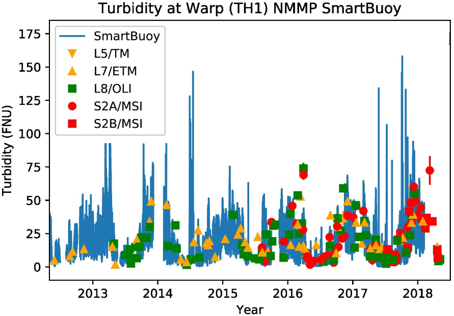
A 6 year time-series of in situ measurements from the WARP SmartBuoy (in blue) and turbidity derived from different satellite sensors.
In two other recent publications, the Dark Spectrum Fitting (DSF) algorithm originally presented for Pléiades by Vanhellemont & Ruddick (2018) was adapted to the decametre scale sensors on board Landsat 5/7/8 and Sentinel-2 A/B (Vanhellemont, 2019a) and CubeSat imagers (Vanhellemont, 2019b). The DSF is now the default algorithm in ACOLITE for processing of Landsat and Sentinel-2 imagery and allows for the processing of imagery from 1984 to present, and thus enables the possibility for long-term studies. DSF processed imagery compared well to in situ measurements from the AERONET-OC network, and turbidity measurements in the North Sea. A partial time-series of turbidity data is shown in the Figure on the left.
Planet (a company operating the world’s largest constellation of Earth-imaging satellites, www.planet.com) can now image the Earth’s land masses daily at metre scale, thanks to >120 CubeSat imagers in orbit. Vanhellemont (2019b) evaluated the present constellation of PlanetScope and RapidEye satellites using in situ measurements at the global AERONET-OC sites, and using autonomous turbidimeters. A good correspondence was found with in situ measurements, hence allowing for high temporal (daily) and spatial (metres) scale estimation of water turbidity. The figure below shows the Dumbarton bridge in South San Francisco Bay during flood tide, with associated bridge pier wakes, and the CubeSat derived turbidity product. Upcoming SuperDoves PlanetScope imagers with 8 spectral bands may provide even more data for aquatic applications.
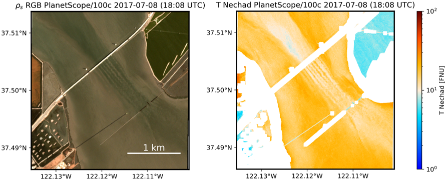
A RGB composite based on PlanetScope Dove data (left) and derived Turbidity product (right) for the Dumbarton Bridge in south San Francisco Bay. Note the turbid bridge pier wakes extending south-east on this flood tide image.
Shanmugam et al. (2019) presented a refined algorithm to compute the Rayleigh-scattering radiance that relies on accurate calculations of the Rayleigh optical thickness (ROT) as a function of the composition of air, (CO2 volume concentration), surface atmospheric pressure and relative air mass for given sun-sensor geometries. The authors noted significant variations of ROT and air mass with location on the Earth’s surface and their influence on the Lr, particularly in the UV-blue region of the spectrum. The refined algorithm for calculating the Lr was tested on MODIS-Aqua data, and the relative errors in Rayleigh-scattering radiance and normalized water-leaving radiance (Lwn) retrievals were compared using in situ data (MOBY, AERONET NOMAD). The results indicate that their refined algorithm retrieved Lwn with lower errors than the SeaDAS algorithm, and produced spatially and temporally consistent biogeochemical products at different latitudes and altitudes.
Lastly, Singh et al. (2019) proposed a new aerosol scattering calculation of UV-NIR approach with non-zero water-leaving radiance approximation for atmospheric correction of satellite imagery in inland and coastal zones. The authors propose a practical method based on a combination of NIR and ultraviolet (UV) bands (named as UVNIR-ex), which replaces the black-ocean assumption and accounts for non-zero water-leaving radiance contributions in the NIR and UV bands. The performance of the UVNIR-ex algorithm was tested on match-ups between HICO and in situ observations in optically complex coastal and inland waters, and by comparison with three alternative aerosol correction methods. A preliminary comparison with in situ aerosol optical thickness (AOT) measurements from AERONET-OC sites revealed that the UVNIR-ex algorithm significantly improved the AOT retrievals as well as Lwn retrievals, and has a significant advantage over the requirement of SWIR bands for turbid and productive waters.
Employment Opportunities
Several new positions have been added to Employment Opportunities on the IOCCG website including Earth Observation Vacancies at Plymouth Marine Laboratory, UK (up to 10 positions), an Ocean Optics Scientist, Sea-Bird Scientific (USA), an Assistant Professor and PhD position at the University of Twente (The Netherlands) and a Postdoctoral Fellow in Hyperspectral Remote Sensing at the University of Zurich (Switzerland). See Employment Opportunities on the IOCCG website for information on these and other positions.
