The IOCCG news bulletins include news from the IOCCG, its sponsoring agencies, and the broader ocean colour community. If you would like to submit an item of interest for the next IOCCG news bulletin, please contact Dr. Raisha Lovindeer, with a cc: to Dr. Venetia Stuart. If you are having trouble receiving email notifications from IOCCG, please see instructions on how to Whitelist “Campaign Monitor” (the IOCCG email marketing platform). Please also add the ioccg.org domain to your safe list (especially important for subscribers with Gmail accounts – also check your SPAM folder). You can also follow IOCCG on Twitter.
IOCCG News
2022 IOCCG Summer Lecture Series
The 5th edition of the advanced IOCCG Summer Lecture Series (SLS) covering topics at the frontier of ocean optics and ocean colour science is scheduled for 18 – 29 July 2022 in Villefranche-sur-Mer. We received a total of 145 applications from scholars all over the world, working on a range of oceanographic remote sensing topics. The selection process was exceedingly competitive this year, with many students having a solid prerequisite of foundational training in ocean colour science. Priority was given to students who demonstrated a clear gap in their knowledge that the course would fill, and for whom training and networking opportunities in ocean colour science at their host institutions were limited. A total of 24 students were chosen to attend the two-week course, which will proceed in-person at the Laboratoire d’Océanographie de Villefranche.
Task Force Update: Remote Sensing of Marine Litter & Debris
![]() The Task Force on Remote Sensing of Marine Litter & Debris, formed in 2020, had their second workshop in March 2022. The Task Force tackles the problem of plastic pollution using a team of international experts who coordinate the advancement of remote sensing technology to detect and observe plastic litter in marine and aquatic environments. The group has four interlinked core topics dealing with remote sensing technologies, algorithms & applications, datasets, and other interdisciplinary aspects related to the emerging research field of remote sensing of marine litter and debris. The workshop was attended by 101 participants, which included Task Force members and guests from 18 countries. It was a means to update the entire Task Force team and members of the public on progress and next steps towards the on-going mission. Read more about the Task Force, including a bibliography of over 60 publications to-date related to remote sensing of marine litter and debris, on their dedicated webpage, or follow them on Twitter @OnLitter.
The Task Force on Remote Sensing of Marine Litter & Debris, formed in 2020, had their second workshop in March 2022. The Task Force tackles the problem of plastic pollution using a team of international experts who coordinate the advancement of remote sensing technology to detect and observe plastic litter in marine and aquatic environments. The group has four interlinked core topics dealing with remote sensing technologies, algorithms & applications, datasets, and other interdisciplinary aspects related to the emerging research field of remote sensing of marine litter and debris. The workshop was attended by 101 participants, which included Task Force members and guests from 18 countries. It was a means to update the entire Task Force team and members of the public on progress and next steps towards the on-going mission. Read more about the Task Force, including a bibliography of over 60 publications to-date related to remote sensing of marine litter and debris, on their dedicated webpage, or follow them on Twitter @OnLitter.
Benthic Reflectance Working Group Kick-Off Meeting
The IOCCG scientific working group on benthic reflectance measurements led by Heidi Dierssen had their kick-off meeting in hybrid format at the University of Miami, 29 – 31 March 2022, hosted by Ved Chirayath. Benthic reflectance is a property describing the colour of the bottom boundary (seafloor, coral, algae, etc.) in aquatic ecosystems. It is an essential parameter for mapping habitats in optically shallow water using remote sensing techniques and has applications in ecology, ecosystem health and function, global change, conservation, marine geology and archeology. The aim of the working group is to produce an IOCCG report that covers an overview of instrumentation and methods, examples of benthic reflectance across different scales and habitats, environmental influences on the measurements, applications and emerging technologies. The kick-off meeting was the first time this diverse group of experts came together to discuss these topics, and they reported a fun, productive, and collaborative meeting. The team has drafted an ambitious report outline and writing timeline, and are looking forward to “wowing you” with this much needed treatise!
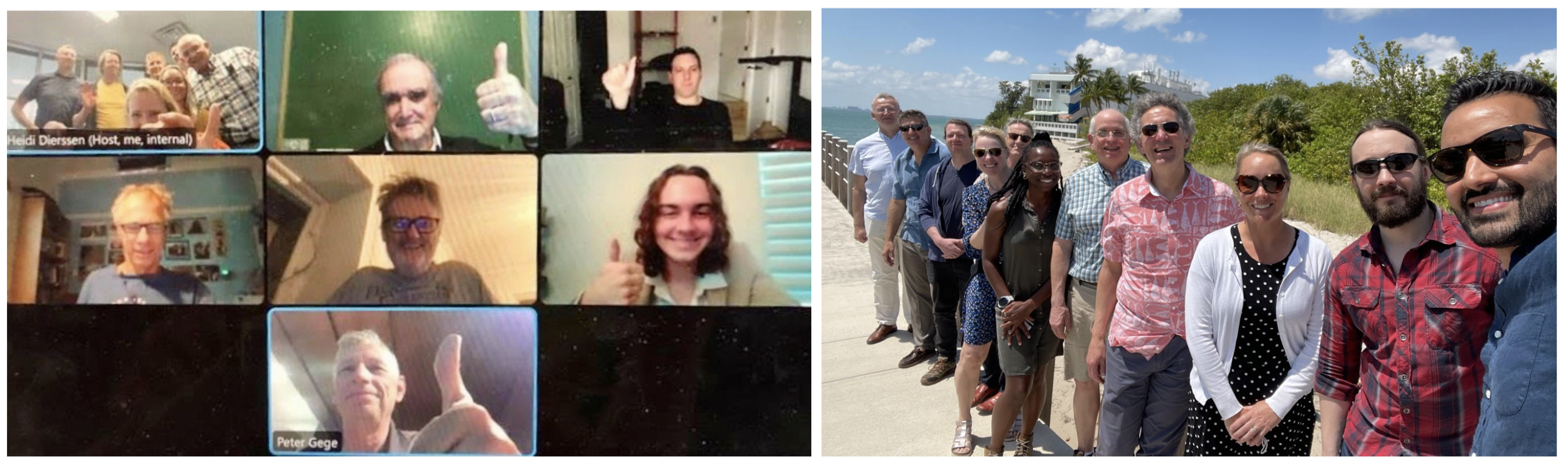
Pictured: (Virtual) George Fournier, Julien Laliberte, Chris Roelfsema, Geir Johnsen, Charles Scrivner, Peter Gege, (In-person) Tiit Kutser, Eric Hochberg, John Hedley, Heidi Dierssen, Arnold Dekker, Stephanie Larie Wright, Richard Zimmerman, Steve Ackleson, Erin Hestir, Brandon Russell, and Ved Chirayath. Not pictured: Natascha Oppelt, Jaime Pitarch Portero, Karen Joyce, Stuart Phinn, Brian Barnes, Jamie Goodman, Wonkook Kim, Sherry Palacios, Gema Pascual
News from NASA
NASA Ocean Color R2022 Processing for OLCI
The Ocean Biology Processing Group announced the initiation of processing of ocean color products from Sentinel-3A/OLCI. Processing of the full mission should be completed in the first week of May 2022. This is the first NASA processing of S3A-OLCI and will be immediately followed by a processing of the S3B-OLCI sensor. Processing of the full mission data for both sensors should be completed by mid-May. The products are accessible for download from the direct access pages for S3A-OLCI and S3B-OLCI. Full details on the processing are available here, and OLCI-specific information is detailed here.
NASA PACE mission update: element-level integration and testing
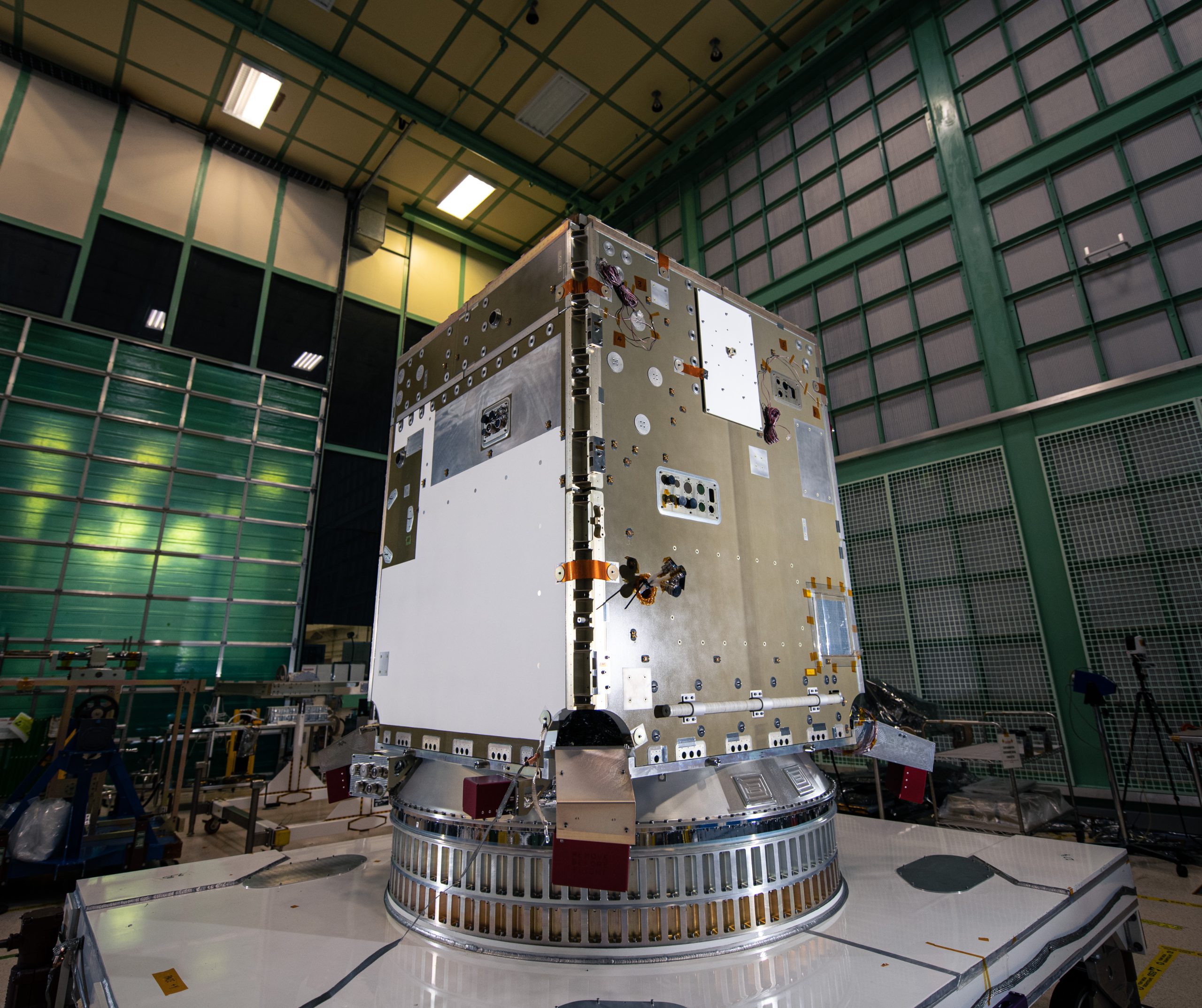 The NASA Plankton, Aerosol, Cloud, ocean Ecosystem (PACE) mission is in the midst of element-level integration and testing (I&T). In this stage of a flight project lifecycle, all individual components of the final observatory – e.g., the instruments and the spacecraft itself, which includes the “bus” as well as its solar panels, transponders, thrusters, and more – are completed and verified. The PACE spacecraft, which is being built at Goddard Space Flight Center, began I&T in September 2021 and will proceed until the third quarter of 2022. The Ocean Color Instrument (OCI), also being built at Goddard Space Flight Center, began I&T earlier this year and will proceed until late 2022. OCI passed its Pre-Environmental testing Review (PER) in late April 2022. This is the review that begins a process of rigorous testing and characterization. Observatory-level I&T, where all elements are integrated to comprise the full PACE observatory, will begin in late 2022 and continue throughout much of 2023. PACE is scheduled to launch in January 2024. To receive routine updates on the PACE mission, become part of the Community of Practice by signing up here.
News from NOAA
NOAA CoastWatch Meeting
 The NOAA CoastWatch Annual Science Meeting will be held May 9-13, 2022 as a hybrid virtual and in-person meeting at the NOAA Center for Weather and Climate Prediction in College Park, Maryland, USA.
NOAA Ocean Color Coordinating Group (NOCCG)
Kimberly Hyde, a member of the NOAA Ocean Color Coordinating Group, and co-editor and co-author of the NOAA Fisheries reports for 2022, shared that the New England and Mid-Atlantic State of the Ecosystem reports have been released! Satellite ocean color data were used in some of the analyses contained in the reports. More information about the reports can be seen here.
NOAA Ocean Color Science Team recent publications
Liu, X. and M. Wang, “Global daily gap-free ocean color products from multi-satellite measurements”, Int. J. Appl. Earth Obs. Geoinf., 108, 102714 (2022). doi:10.1016/j.jag.2022.102714
EUMETSAT and NOAA OSOS2 Summary Workshop Report Available
 The Second International Operational Satellite Oceanography Symposium (OSOS-2) Summary Workshop Report was published on 31 March 2022. This report recaps the successful EUMETSAT-NOAA co-sponsored virtual meeting that was held in May 2021. It is publicly available on the OSOS-2 meeting website.
Upcoming Events
Ocean Optics XXV Abstracts due May 4
 Ocean Optics XXV will take place from 2 – 7 October 2022, at the International Centre for Interdisciplinary Science and Education (ICISE) in Quy Nhon, Binh Dinh, Vietnam. This will be the 25th anniversary of the conference and aims to bring the community together to share current research results and collaborate on future projects.
Conference registration is open with payment due on 1 August 2022. Abstracts are due on 4 May 2022. See the conference website for additional information on travel, lodging, short courses, and workshops. For more information, please contact Jenny Ramarui, Ocean Optics XXV Conference Coordinator.
ESA Living Planet Symposium 2022
 The European Space Agency’s 2022 Living Planet Symposium is scheduled for 23-27 May 2022 at the World Conference Center in Bonn, Germany. The symposium will focus on how Earth observation contributes to science and society. The symposium will also address how disruptive technologies can change the landscape of traditional Earth observation. Registration closes on 9 May 2022.
Professional Development Workshop based on IOCCG Protocols: deadline extended to May 10
 A professional development workshop: best practices for the collection and processing of ship based underway flow-through optical data will be held from 1 – 5 August 2022 at the Darling Marine Center in Walpole, Maine, USA. The 5-day workshop will be led by Emmanuel Boss, Guillaume Bourdin and Lee Karp-Boss, and will focus on standardized and coordinated data collection and processing methods as highlighted in IOCCG Protocol Series Volume 4: Inherent Optical Property Measurements and Protocols: Best Practices for the Collection and Processing of Ship-Based Underway Flow-Through Optical Data. The workshop will include hands-on experience in setting an inline system on a ship or dock, and data logging and processing, as well as an overview of optical sensors and their principles of measurements, calibrations, installation, and best practices for quality control while at sea and during data processing. Read the full workshop description and apply by May 10!
Journal Special Issues
Reliable Detection of Water Quality and Aquatic Ecosystem Dynamics in Inland Waters
![]() Final call for papers for a Special Issue on Reliable Detection of Water Quality and Aquatic Ecosystem Dynamics in Inland Waters (Remote Sensing, section: Environmental Remote Sensing) as the deadline for submission closes on 31 May 2022.
Final call for papers for a Special Issue on Reliable Detection of Water Quality and Aquatic Ecosystem Dynamics in Inland Waters (Remote Sensing, section: Environmental Remote Sensing) as the deadline for submission closes on 31 May 2022.
The Special Issue will focus on remote sensing approaches dedicated to freshwater ecosystems and inland water quality. Highlight of key topics include national, continental or global scale analysis of water quality and its dynamics; integration of remote sensing products into classical monitoring programmes; combinations of aquatic and terrestrial remote sensing products for analysing catchment-water-interactions; and feasibility of the new sensing platforms (UAVs) for water quality monitoring solutions.
Guest editors for the special issue are Karsten Rinke, Shushanik Asmaryan, Peter Hunter and Caren Binding. See the website for details on submissions.
New Publications
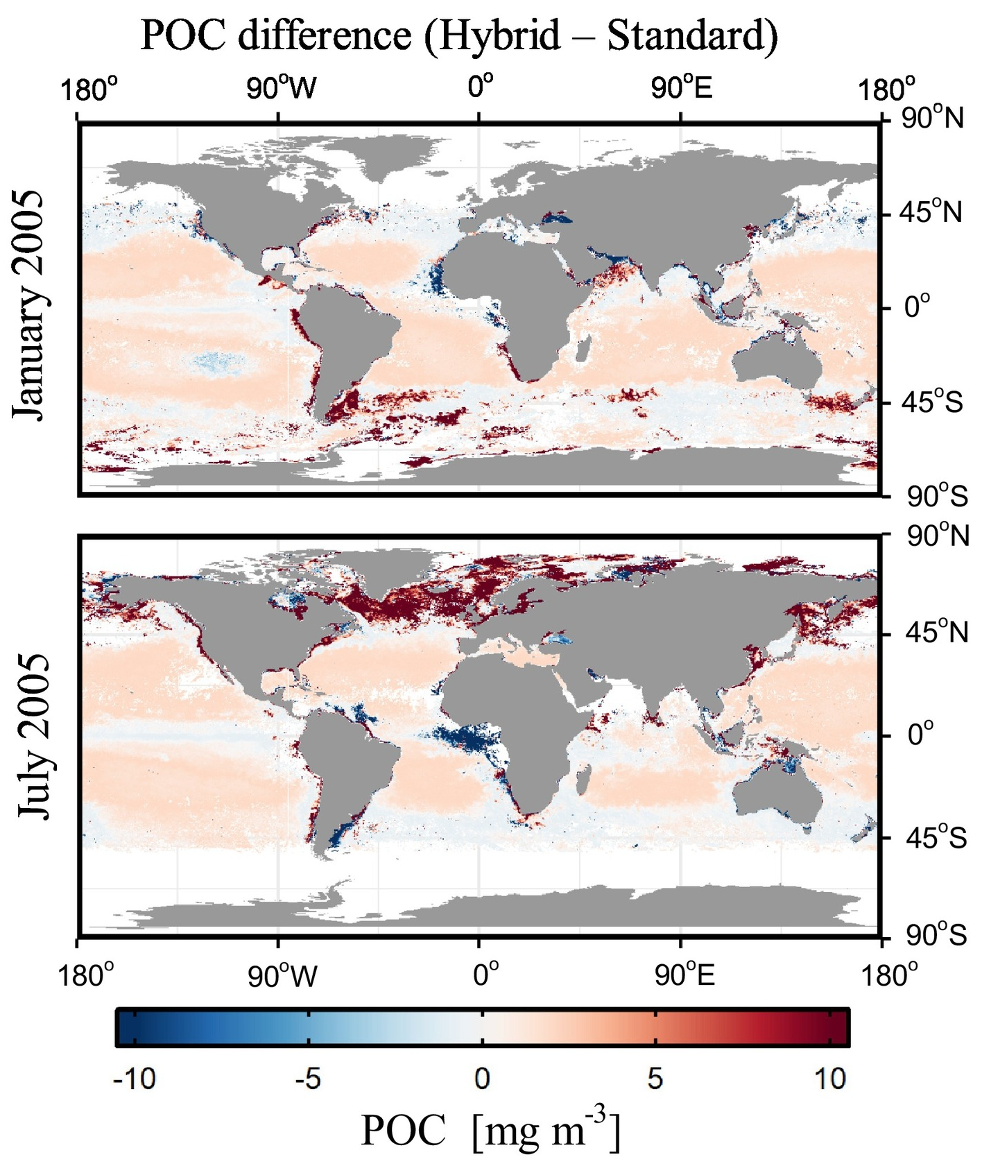
Difference between monthly composite POC values derived from the hybrid algorithm and the current standard algorithm used by NASA Ocean Biology Processing Group applied to SeaWiFS observations during two example months, January 2005 and July 2005.
Stramski et al 2022 formulated a new suite of empirical ocean color algorithms that estimate the concentration of particulate organic carbon (POC) in global ocean surface waters from observations with past and present satellite ocean color sensors. For algorithm development the authors assembled a field dataset of concurrent POC and remote-sensing reflectance, Rrs(λ), measurements from all major ocean basins encompassing tropical, subtropical, and temperate latitudes, as well as northern and southern polar latitudes. The resulting dataset is characterized by a globally-representative probability distribution of POC with a broad range of values between ~10 and 1000 mg m-3. The dataset was subject to parametric regression analysis. Over seventy formulas for estimating POC from Rrs(λ) were evaluated, using seven distinctly different algorithmic categories, each with a fundamentally different definition of the independent variable involving Rrs(λ). Through comparative analysis of goodness-of-fit statistics, final POC algorithms were selected and formulated for the spectral bands of SeaWiFS, MODIS, VIIRS, MERIS, and OLCI satellite sensors. These algorithms are referred to as hybrid algorithms and consist of two components: the Maximum Band Ratio cubic polynomial function (MBR-OC4) and the Band Ratio Difference Index (BRDI) quintic polynomial function. The MBR-OC4 is used for POC > 25 mg m-3 and the BRDI for POC < 15 mg m-3 with a weighting approach in the transition region. Compared with predecessor algorithms, especially the current global POC algorithm used by NASA, the MBR-OC4 is expected to provide improvements for relatively high POC values greater than a few hundred mg m-3. The BRDI is expected to provide improvement in ultra-oligotrophic waters, where POC is very low. A preliminary analysis of field-satellite matchup datasets based on SeaWiFS and MODIS-Aqua observations showed improved performance of hybrid algorithms compared with current standard algorithms. In addition, reasonable consistency was demonstrated between POC derived from hybrid algorithms applied to example satellite observations with SeaWiFS, MODIS-Aqua, and VIIRS-SNPP. This suite of newly developed hybrid algorithms are potentially the next generation of global algorithms that better represent spatial and temporal variability within a broader range of POC than the predecessor global algorithms. They also offer the capability to generate a long-term sensor-to-sensor consistent data record of POC, beginning with the launch of the SeaWiFS mission in 1997.
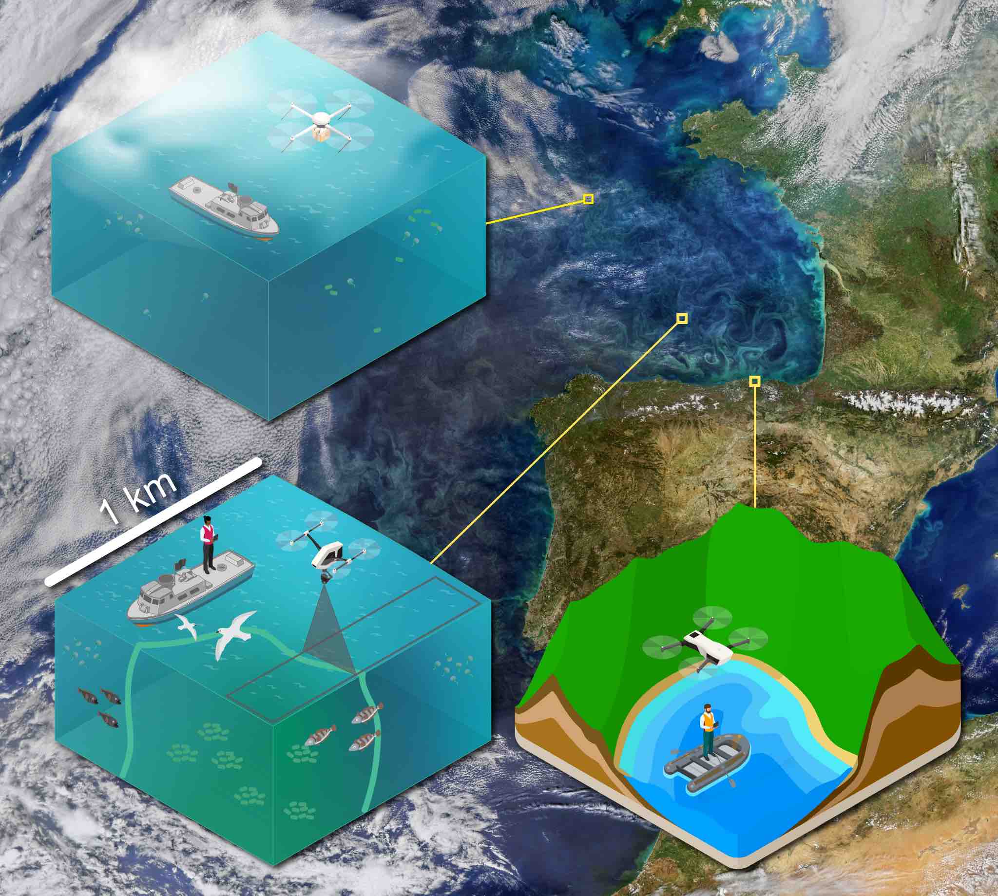 Gray et al., 2022 reviewed applications of aerial drones in ocean color and painted a vision of how drones can fill the gap between satellite and in-situ sampling in biological oceanography. They discussed how critical biophysical processes unfold at scales of space and time, which are challenging to observe with current methods, but can be successfully monitored via drones. The authors discussed how optical, logistical, and regulatory challenges have slowed the adoption of drones in biological oceanography and outline some best practices for mitigating these challenges. Finally they shared a vision for the role that drones can play in submesoscale oceanography, coastal monitoring, calibration and validation of satellite products, and model comparison and parameterization. All together, their work suggests and describes how drones can complement conventional approaches in biological oceanography to more fully capture the spatiotemporal complexity of the marine environment.
Hidaka et al. 2022 developed a deep learning model to monitor beach litter that gives pixel-level image classification to beach images to automatically identify different-sized litter. Images resolve into 8 classes, including artificial and natural litter classes. The accuracy of the model was evaluated qualitatively and quantitatively, and the detection accuracy of the model for artificial litter on the test data was around 80%. The usefulness of the method was demonstrated from good results on images taken in different areas from those of the training images. The authors showed the potency of the method for cover area estimation by comparing results from projection transform of the ground image inference with drone image ground truthing. The resulting training dataset used in the research is now publicly available from SEANOE – Sea Open Scientific Data Publication.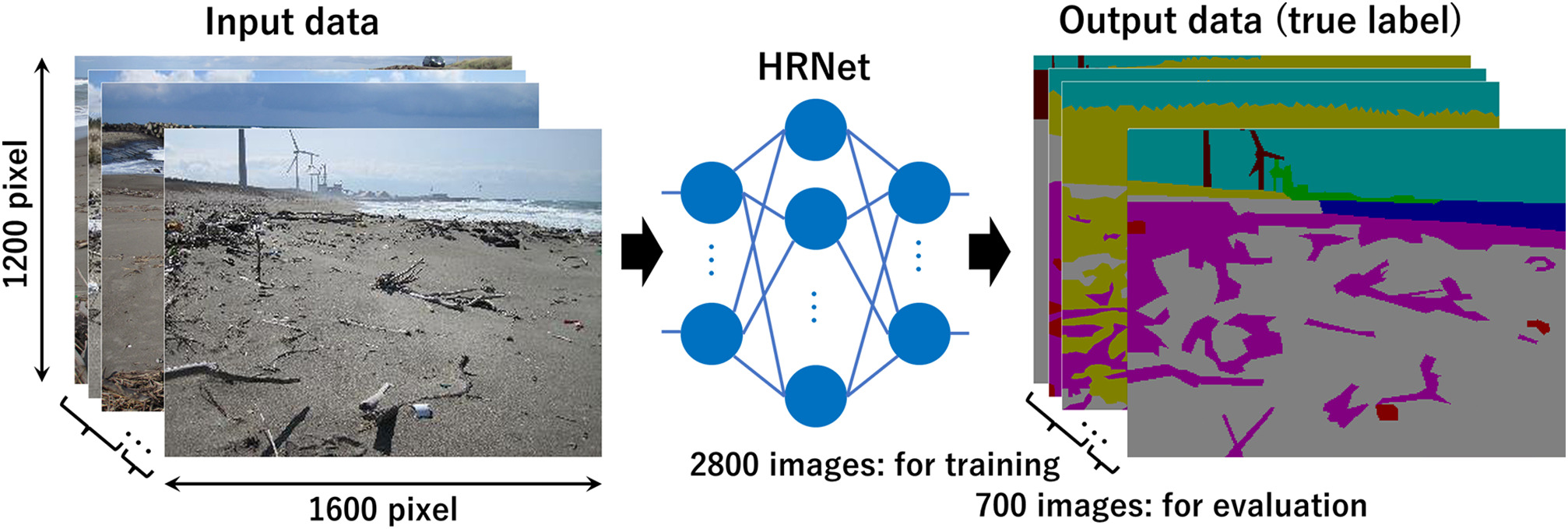
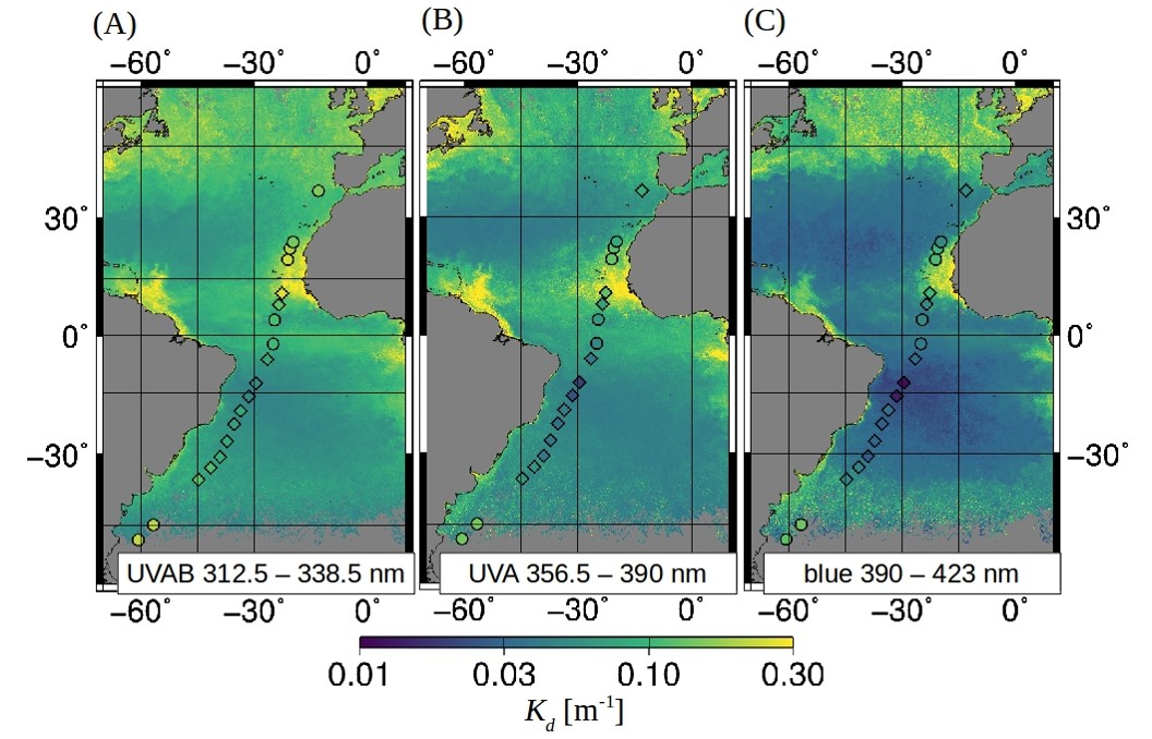
TROPOMI Kd-UVAB (A), Kd-UVA (B), and Kd-blue (C) in the Atlantic Ocean gridded at 0.083◦ average for 11 May to 9 June 2018. Kd-UVAB, Kd-UVA, and Kd-blue measured in-situ at 19 stations during expedition PS113 are overlaid as diamonds (match-ups) and circles (unmatched stations). Adapted from Oelker et al. 2022, Fig. 5
Though sunlight plays an important role in the ocean, high-energetic ultraviolet (UV) radiation can be both beneficial and detrimental to aquatic organisms. The interaction of UV with the ocean is generally complex, and most processes feedback with climate warming. Modeling and satellite-based observations of light penetration into the ocean are used to understand these processes, but traditional satellite ocean color sensors don’t measure the UV range. Information on UV light penetration is inferred indirectly from measurements of visible wavelengths, and is connected to larger uncertainties. Oelker et al. 2022 exploited backscattered UV to blue light data at continuous spectral resolution of 0.5 nm of the TROPOMI sensor onboard the Sentinel-5-Precursor satellite. They present the first direct satellite-based observations of shortwave penetration, in terms of the diffuse attenuation (Kd) into the ocean ranging from the UV to the blue spectral domain. Their approach is based on Differential Optical Absorption Spectroscopy which retrieves the vibrational Raman scattering (VRS) signal, and then combines coupled ocean-atmosphere radiative transfer modeling (RTM) to derive Kd in the UV (312.5 – 338.5 nm and 356.5 – 390 nm) and blue (390 – 423 nm) range. The VRS signal is well detected in TROPOMI measurements (fit errors <15%). TROPOMI Kd retrievals exhibit low sensitivity to parametrization of oceanic and atmospheric effects and show good agreement to Kd obtained from in situ measurements. These products have a high potential to satisfy the user needs in the modeling community, which require spectral information on shortwave light penetration for improving estimates of the ocean’s heat budget, primary productivity, photochemical reaction rates of climatically important compounds, and UV dose rates as an indicator for damaging effects on aquatic organisms.
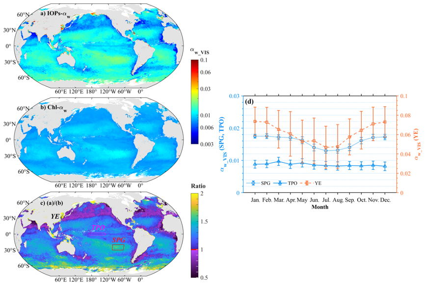
Global distribution of αw_VIS estimated by (a) IOPs-αw and (b) Chl-αw in March 2019 using the VIIRS monthly composite data, with their differences shown in Panel (c). Panel (d) presents the monthly variation of the median αw_VIS estimated by IOPs-αw in three regions of interest in the South Pacific Gyre (SPG), the Tropic Pacific Ocean (TPO), and the Yangtze Estuary (YE) in 2019, with their locations highlighted in panel (c). The error bar in panel (d) represents the standard deviation of αw_VIS in each region.
Yu et al., (2022) estimates the water-leaving albedo from ocean colour based on inherent optical properties (IOPs). Water-leaving albedo (αw) is defined as the ratio of water-leaving irradiance to downwelling irradiance just above the surface, and is a major component of ocean surface albedo (α). But αw has been significantly underrepresented due to the use of the conventional scheme based on chlorophyll-a concentration (termed Chl-αw). A semi-analytical scheme based on IOPs, termed IOPs-αw, was proposed in this study for the accurate estimation of spectral αw(λ) from ocean color. Evaluations with numerical simulations of radiative transfer show that IOPs-αw outperforms Chl-αw—the median absolute percentage difference (MAPD) of derived αw(λ) from IOPs-αw is generally less than 3% for the simulated dataset, in comparison to MAPD of over 40% for that from Chl-αw. Demonstrations with Visible Infrared Imaging Radiometer Suite (VIIRS) monthly composite data show that the broadband αw in the visible domain, termed αw_VIS, obtained via IOPs-αw is over 50% higher than the previous estimation by Chl-αw in most oceanic waters. Higher αw_VIS is also characteristic of strong spatial-temporal variations in global oceans. The study concludes that water-leaving albedo could contribute up to 20% to α in oceanic waters under low solar-zenith angles. The authors suggest that neither the spatial variability of αw_VIS nor the contribution of αw_VIS to α should be neglected, and it is necessary to incorporate IOPs-αw into current parameterizations of α in coupled ocean-atmosphere and climate models.
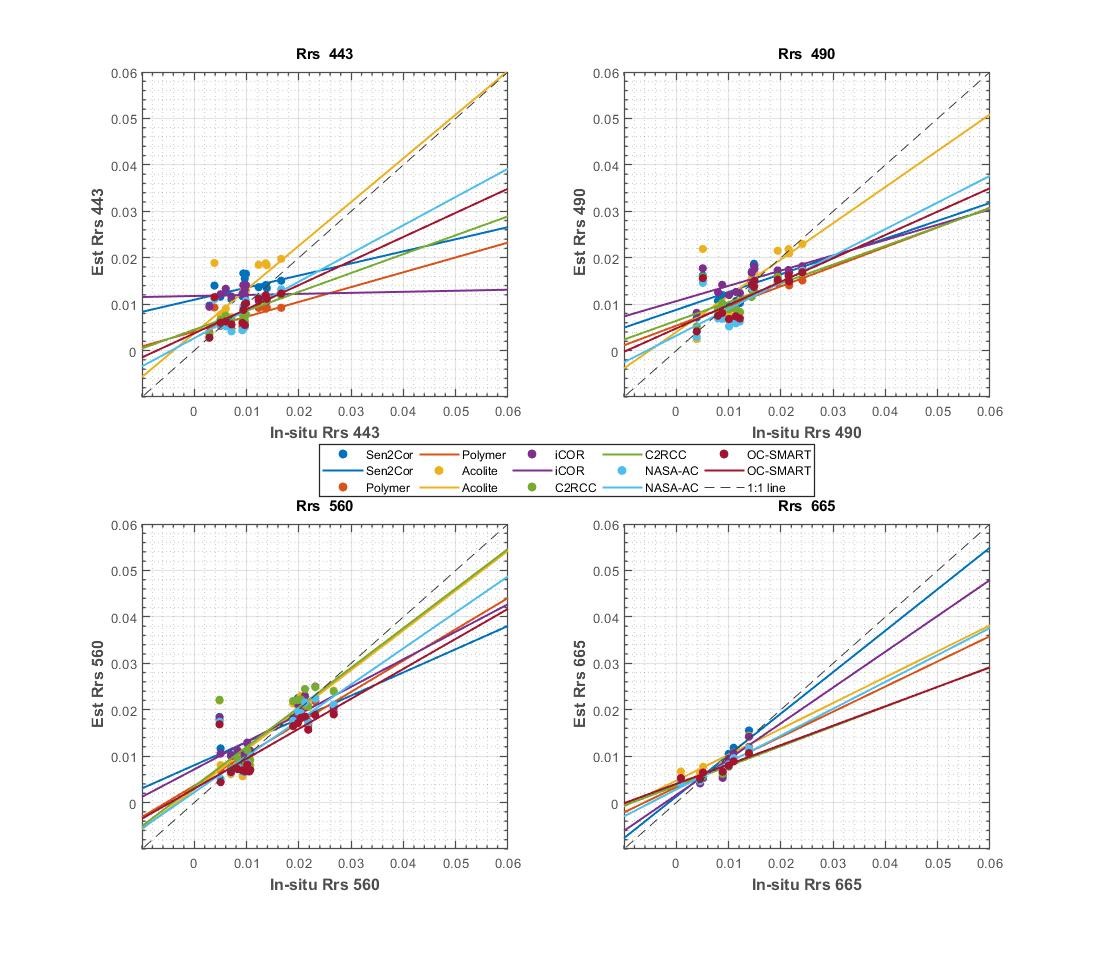
Scatter plots of the estimated Rrs (y-axis) vs in situ Rrs (x-axis) for the seven atmospheric correction algorithms at 443 nm, 490 nm, 560 nm, and 665 nm. The dotted line is the 1:1 line and solid lines present the linear regression between the atmospheric correction retrievals and the field measurements Rrs.
Bui et al 2022 compared seven atmospheric correction algorithms over two French coastal regions in the English Channel and French Guiana. The algorithms were the Image correction for atmospheric effects (iCOR), Atmospheric correction for OLI ‘lite’ (ACOLITE), Case 2 Regional Coast Colour (C2RCC), Sentinel 2 Correction (Sen2Cor), Polynomial-based algorithm applied to MERIS (Polymer), the standard NASA atmospheric correction (NASA-AC) and the Ocean Color Simultaneous Marine and Aerosol Retrieval Tool (OC-SMART). Satellite-estimated remote sensing reflectance were spatially and temporally matched with in situ measurements collected by an ASD FieldSpec4 spectrophotometer. Results were based on 28 potential individual match-ups and reported standard statistical parameters, as well as metrics about the shape of the retrieved spectra. Sensitivity analyses were conducted to estimate the impact of the measurement structure on the quality of the match-ups. Read the paper for more details.
New Opportunities
POGO-SCOR Visiting Fellowship programme
 Applications are not open for the Partnership for Observation of the Global Ocean (POGO) and the Scientific Committee on Oceanic Research (SCOR) Visiting Fellowship programme for 2022. The programme is designed to promote training and capacity development, leading towards a global observation scheme for the oceans. It is aimed at scientists, technicians, graduate students (preferably PhD) and post-doctoral fellows involved in oceanographic work at centres in developing countries and countries with economies in transition. Priority is given to applicants in the early stages of their career development. The fellowship offers the opportunity to visit other oceanographic centres for a 1 to 3 months period for training on aspects of oceanographic observations, analyses, and interpretation. The fellowship provides financial support to cover the return airfare from the fellow’s home country to the host institution, and a contribution towards accommodation and subsistence for the period of the visit. The Application deadline is 8 May 2022. Click here for more information and details on how to apply.
Employment and PhD research positions
New employment and research opportunities have been added to the IOCCG website. Some with upcoming deadlines include:
- PhD in Remote Sensing of Aquatic Primary Production, Eawag (Swiss Federal Institute of Aquatic Science and Technology).
- PhD Fellowship Position in Remote Sensing of Ocean Colour at Laboratory of Oceanology and Geosciences LOG, Wimereux, France.
- Postdoctoral Scholar(s) in Satellite Ocean Color Research & Applications at the College of Marine Science, University of South Florida, USA
- CNRS Research Engineer/Professional in remote sensing and algorithmic development in the Arctic Ocean at Laval University, International Research Lab, Takuvik, Canada.
Click here For more information on these and other positions. If you would like to include a position on this page, please contact Raisha Lovindeer
