News from the IOCCG
IOCCG Ocean Optics & Biogeochemistry Protocols
![]() Over the past few years NASA has sponsored several international workshops with experts (including breakout workshops at the International Ocean Colour Science meetings) to update and develop new community consensus protocols for ocean colour sensor validation. The newly drafted document Inherent Optical Property Measurements and Protocols: Absorption Coefficient, is available on the IOCCG website for a 60-day public comment and review period before being accepted as the international reference standard.
Over the past few years NASA has sponsored several international workshops with experts (including breakout workshops at the International Ocean Colour Science meetings) to update and develop new community consensus protocols for ocean colour sensor validation. The newly drafted document Inherent Optical Property Measurements and Protocols: Absorption Coefficient, is available on the IOCCG website for a 60-day public comment and review period before being accepted as the international reference standard.
The document will be revised based on comments received, formatted, and a final pdf document will be produced and posted on the IOCCG website. The final protocols will receive a publication date and version number (e.g., v1.0), and will also have a digital object identifier (doi). The protocols will be revisited periodically to determine if enough changes have taken place to warrant a significant update, in which case a new version number will be assigned.
Comments are welcome and may be sent to ap_comments@oceancolor.gsfc.nasa.gov before the deadline 29 November 2017. Click here to download the absorption coefficient protocols document.
JAXA GCOM-C Mission Launch Date
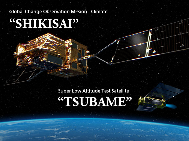 The Japan Aerospace Exploration Agency (JAXA) recently announced the launch date of the much anticipated Global Changing Observation Mission – Climate (GCOM-C), nicknamed “SHIKISAI” (meaning colour in Japanese). GCOM-C will be launched between 10:26:22 thru 10:48:22 a.m. (JST) on 23 December 2017 from the Tanegashima Space Center in Japan (reserve launch period: 24 December 2017 to 31 January 2018). GCOM-C will be launched together with the Super Low Altitude Test Satellite “TSUBAME” (SLATS), with each mission being inserted into a different orbit. See the press release for full details.
The primary goal of the GCOM-C mission is to contribute to surface and atmospheric measurements related to climate change with emphasis on the carbon cycle and the radiation budget. The payload consists of the Second Generation Global Imager (SGLI), an advanced multi-purpose visible/infrared imager of GLI heritage. The objective is to measure ocean colour, land use and vegetation, snow and ice, clouds, aerosols and water vapor.
News from ESA
Research and User Support for Sentinel Core Products
 The RUS service (Research and User Support for Sentinel core products) aims to promote and develop the use of Sentinel datasets. This project is founded by the European Commission and managed by ESA. This RUS service is freely available to everyone, from first time data users to specialist users. In this frame, the RUS service provides:
– Access to a powerful computing environment based on scalable virtual machines (adjusted to the user’s specific ICT needs).
– Access to all the necessary tools (e.g., EO software, developing tools) for Sentinel satellites data processing.
– Personalised advice and assistance from Sentinel team experts (via chat, email, phone).
– Access to hands-on training and webinars.
The RUS portal is available at: https://rus-copernicus.eu/. Here users will find information about the RUS project and will be able to create an account and to submit a request to get access to a free RUS service.
ESA Workshop on Uncertainties in Remote Sensing
![]() The Quality Assurance Framework for Earth Observation (QA4EO) states that “all EO data and derived products have associated with them a documented and fully traceable quality indicator (QI)”. In remote sensing, provision of uncertainty information is a fundamental aspect of indicating data quality: an uncertainty associated with a measurement is required to allow proper interpretation and further application of data, both in scientific and decision-making contexts. For this reason, ESA hosted a workshop on Uncertainties in Remote Sensing (Frascati, Italy, on 24- 25 October 2017) to:
The Quality Assurance Framework for Earth Observation (QA4EO) states that “all EO data and derived products have associated with them a documented and fully traceable quality indicator (QI)”. In remote sensing, provision of uncertainty information is a fundamental aspect of indicating data quality: an uncertainty associated with a measurement is required to allow proper interpretation and further application of data, both in scientific and decision-making contexts. For this reason, ESA hosted a workshop on Uncertainties in Remote Sensing (Frascati, Italy, on 24- 25 October 2017) to:
- Review the ‘state of the art’ in uncertainties in remote sensing,
- Present the theory of uncertainties in remote sensing,
- Understand differences and discuss the limitations of various methodologies,
- Discuss the validation of uncertainties,
- Solicit recommendations and prepare a roadmap for implementation in “operational” missions.
Sentinel-2 Validation Team (S2VT) Meeting
 The European Space Agency is pleased to call for the second gathering of the Sentinel-2 Validation Team (S2VT). The second meeting of the S2VT will take
place on 29-31 January 2018, at ESRIN, Frascati, Italy. The S2VT will be composed of groups of experts who collectively contribute and provide feed-back to the Agency on quality aspects of the Sentinel-2 data products, their algorithms and the cal/val activities.
More information on the S2VT meeting, and the registration procedure is available on the following website:
https://nikal.eventsair.com/sentinel-2-validation-team-meeting/s2vtm.
The S2VT 2018 Organising Committee also invites you to submit an abstract to the Meeting. The abstract submission deadline is 30 November 2017.
News from EUMETSAT
Sentinel-3 Validation Team meeting, 12-16 March 2018, Darmstadt, Germany
 The fourth S3VT meeting will take place at EUMETSAT Headquarters in Darmstadt, Germany, in the week of 12-16 March 2018. The meeting will feature in-depth discussion around the results from the scientific validation of the operational products after 2 years of the Sentinel-3 A mission, and plans and prospects for the calibration and validation for the upcoming Sentinel-3B. The Sentinel-3 Validation Team is co-chaired EUMETSAT and ESA.
Participation in the S3VT is open under the rolling S3VT Announcement of Opportunity throughout the operational phase of the mission. Click here for more information. The registration page for the meeting will open in due course and more detail on the programme will be available at the meeting website in that time.
Sentinel-3A OLCI Full Mission Reprocessing
S3A OLCI full mission reprocessing is now being accomplished. It will give to all users access to consistent OLCI ocean colour time series from the beginning of the mission, end of April 2016, to the current date. The reprocessing includes updated modelling of OLCI radiometric evolution for the full time period. Reprocessed OLCI data will be available from the Marine Centre before the end of 2017 at coda.eumetsat.int.
News from NOAA
![]() On two recent telecon meetings, the NOAA VIIRS Ocean Color Cal/Val team hosted Kevin Ruddick in his capacity as the lead author of the technical document “Fiducial Reference Measurements for Satellite Ocean Colour (FRM4SOC) D-60 Technical Report TR-1: Measurement Requirements and Protocols when Operating Fiducial Reference Measurements” being written for ESA. Ruddick briefed the Cal/Val team about the document intentions and content and the Cal/Val members provided feedback. Overall, it was a very productive interaction. The ESA document will help guide some of the work being done on the NOAA dedicated VIIRS ocean color Cal/Val cruises and NOAA appreciates being given the opportunity to contribute to the content of this technical document that will be useful to the international ocean color remote sensing community.
On two recent telecon meetings, the NOAA VIIRS Ocean Color Cal/Val team hosted Kevin Ruddick in his capacity as the lead author of the technical document “Fiducial Reference Measurements for Satellite Ocean Colour (FRM4SOC) D-60 Technical Report TR-1: Measurement Requirements and Protocols when Operating Fiducial Reference Measurements” being written for ESA. Ruddick briefed the Cal/Val team about the document intentions and content and the Cal/Val members provided feedback. Overall, it was a very productive interaction. The ESA document will help guide some of the work being done on the NOAA dedicated VIIRS ocean color Cal/Val cruises and NOAA appreciates being given the opportunity to contribute to the content of this technical document that will be useful to the international ocean color remote sensing community.
Historic Digital Archive

Pietro Secchi (1818 – 1878) and his secchi disk and sphere, used to measure water transparency.
Over a period of ~20 years, Marcel Wernand (Royal Netherlands Institute for Sea Research) has assembled a historic digital archive (http://www.clarityonthesea.org/search-archive) of over 450 articles on the colour and clarity of water, written between the 17th and early 20th century. The archive contains research papers and digitized books from several digital libraries. All books and papers are in PDF format and freely downloadable for scientific use. The database can be searched using keywords such as colour, forel, Vogel, Secchi etc.
Light, colour and clarity are intriguing features that have driven philosophical and scientific investigations throughout history. The same holds true for mankind’s fascination of the sea. Thus it is not surprising that the combination of both sea and light i.e., the field of ocean colour observation, has a long record of innovations and applications. Yet these insights are sometimes hidden in paper archives and long forgotten publications, which are not accessible to the broader community. Within this digital archive numerous publications are included from the discipline of ocean optics that were extracted and referenced from historic documents, offering a glance into the past of optics in the sea. It is also a joy to read historic quotes, scientific travels, explorations of the world, as well as the design of the earliest marine optical instruments (click here for further information and images or search the archive).
SCOR WG on Plankton-Observing Sensor Systems
 A new SCOR working group on “Integration of Plankton-Observing Sensor Systems to Existing Global Sampling Programs” has been provisionally approved. The primary goal of the working group is to identify measurements that can expand the number of observations of biological stocks, diversity, and rates or fluxes of planktonic organisms. The objective is to identify methods and technologies that can be incorporated into large-scale sampling programs such as GO-SHIP and OceanSITES as well as other similar programs from around the world. Emphasis of the WG would be on methods and technologies that can be implemented in the short term without disruption to established observing programs, and identifying gaps and opportunities that can significantly increase the number of routine and sustained observations of life in the ocean in the longer term.
A document produced by this WG will identify the rationale for each measurement, associated costs and human investment (e.g., technical expertise and time needed), and data collection, quality control (QC), and data archival protocols. The group will also identify synergies with other programs (e.g., Biogeochemical-Argo, spaced-based measurements) to provide complementary measurements and cross-validation. This is a great opportunity to expand collection of data useful for calibration and validation of ocean colour sensors (e.g., HPLC, POC, in-line and in situ bio-optics, genetics, imaging etc.). Click here to read the full proposal.
Best Wishes to Jim Yoder
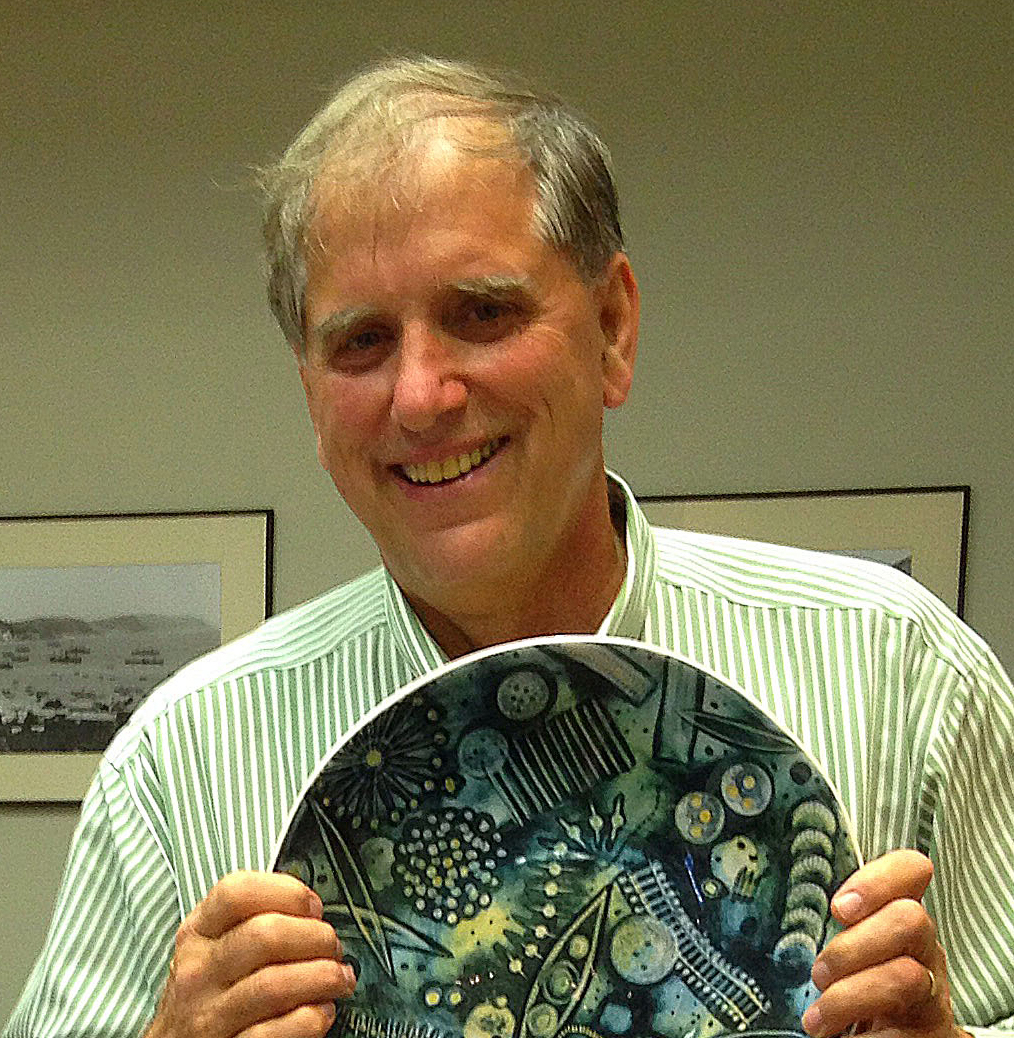 As many of you many know, James (Jim) Yoder is a prominent ocean colour scientist and has been involved in ocean colour research for many years. Furthermore, he was one of the founding members of IOCCG, having attending the very first IOCCG Committee meeting in 1996. Furthermore, Jim also ably served as Chair of the IOCCG Committee from 2006 – 2009 and played a big role in the formation of the CEOS Ocean Colour Radiometry-Virtual Constellation (OCR-VC), helping to sustain the routine collection of critical ocean colour observations.
Jim recently announced his retirement from Woods Hole Oceanographic Institution where he served as Vice President for Academic Programs and Dean. On behalf of the IOCCG Committee and ocean colour community we’d like to wish Jim the happiest of retirements – with all his wisdom and experience we are happy to report that he will still stay involved in ocean colour science.
Special Issue: Remote Sensing in Coastal Zone Monitoring and Management
![]() The journal Remote Sensing will have a special issue entitled “Remote Sensing in Coastal Zone Monitoring and Management —How Can Remote Sensing Challenge the Broad Spectrum of Temporal and Spatial Scales in Coastal Zone Dynamic?”. This Special Issue will highlight how remote sensing can tackle the monitoring of nearshore dynamics thanks to recent progress made in terms of sensors’ radiometric, spatial, and temporal resolutions, together with new data processing methods, products, and applications. For more information, see the full announcement. Deadline for manuscript submissions: 15 July 2018.
The journal Remote Sensing will have a special issue entitled “Remote Sensing in Coastal Zone Monitoring and Management —How Can Remote Sensing Challenge the Broad Spectrum of Temporal and Spatial Scales in Coastal Zone Dynamic?”. This Special Issue will highlight how remote sensing can tackle the monitoring of nearshore dynamics thanks to recent progress made in terms of sensors’ radiometric, spatial, and temporal resolutions, together with new data processing methods, products, and applications. For more information, see the full announcement. Deadline for manuscript submissions: 15 July 2018.
New Publications
Several new publications have been added to the IOCCG Recent References list including a paper by Raitsos et al. (2017) demonstrated the usage of remote sensing datasets in tracking pathways for gene flow in the Red Sea. Coral reefs rely on connectivity (exchange of biological information) to maintain gene flow, biodiversity and ecosystem resilience. The more connected the reefs are, the better communication (gene exchange) they have, which can translate into healthier reefs, more resilient to anthropogenic pressures (climate change, pollution, over-harvesting). The authors from Plymouth Marine Laboratory used satellite remote sensing observations to trace these connections, and identify how well connected or isolated the reefs are. They integrated satellite-derived biophysical observations, particle dispersion model simulations, genetic population data and ship-borne in situ profiles to assess reef connectivity in the Red Sea.
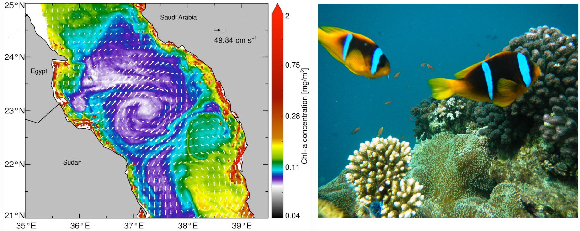
(a) Altimeter-derived geostrophic currents superimposed on remotely-sensed chlorophyll observations. (b) Clownfish used for genetic population data
Using ocean colour imagery, they visualized dynamic circulation features (eddies and currents) that transport productive water masses between reefs in the Red Sea. These observations were substantiated with in situ measurements from collaborators at the King Abdullah University of Science and Technology (KAUST), Saudi Arabia. Next, they simulated long-term (>20 yrs.) connectivity patterns driven by remotely-sensed geostrophic currents to calculate the source/sink dynamics in Red Sea coral reefs. With this experiment, conservation hotspots (reefs) were identified that are key sources of fish eggs and coral larvae in the region. To examine if the remotely-sensed approach had an ecological substance, they evaluated their outputs against estimates of genetic distance among populations of clownfish, along the eastern Red Sea coastline (1500 km). They found that the predicted connectivity was remarkably consistent with genetic population data, demonstrating that circulation features formulate physical pathways for gene flow in the Red Sea. As the satellite datasets are freely available globally, their analysis demonstrates a cost-effective tool to estimate biophysical connectivity remotely, which may support coastal management in data-limited regions.
In another new publication, Hou et al. (2017) developed a generic remote sensing algorithm for TSS (total suspended sediment) concentrations based on the ratio between 555 and 645 nm of the MODIS surface reflectance data, and in situ data from 58 lakes. The algorithm was implemented for 102 large lakes and reservoirs in the middle and lower basins of the Yangtze River (MLY), China. They created the first comprehensive image of the TSS distributions and dynamics of large water bodies in MLY between 2000 and 2014. They found that the turbidity of 64.5% of the lakes (49 in total) which are not freely connected with Yangtze River (Class II) exhibited decreasing trends over the 15 years. The Three Gorges Reservoir (TGR) and Dongting Lake (Yangtze-connected lakes) also showed significant TSS declines. This TSS decrease of Class II lakes might be linked with the significant NDVI increase in MLY basin, whereas the impoundments of Three Gorges Dam is likely the main factor contributing to the TSS decrease of TGR and Dongting Lake. The TSS environment data record of large lakes and reservoirs presented in this study can provide an important reference for water quality monitoring and estimation in the MLY of China.

(a) Spatial distributions of TSS rate changes for the studied lakes and reservoirs (↑= statistically significant increasing trends from 2000 to 2014, ↓ = significant decreasing trends). (b) Number of lakes/ reservoirs with statistically significant decreasing/increasing TSS trends for three classes of lakes. (c) Details of the middle component of the MLY basin.
Employment Opportunities
Several new positions have been added to Employment Opportunities on the IOCCG website including a research faculty position in coastal/inland water remote sensing (SUSTech, China), three engineer positions (LOV, France and Tartu Observatory, Estonia), three postdoctoral fellow positions (CSIRO, Australia, U. North Dakota, and U. Maryland, USA), two studentships in the UK, and a lecturer/Associate Professor in freshwater/ marine EO (U. Stirling, UK).
