IOCCG news bulletins include items of interest from the IOCCG, its sponsoring agencies, as well as the broader ocean colour community (including new publications). Please let us know if there are any other items of interest you would like to see included in the next IOCCG news bulletin (contact Raisha Lovindeer). You can also follow IOCCG on Twitter.
IOCCG News
Congratulations to the inaugural IOCCG Platt Scholars
 Congratulations to Arjun Adhikari and David Alejandro González Rivas, the IOCCG Platt Scholars selected for the inaugural award of the IOCCG Trevor Platt Memorial Scholarship in February 2023.
A total of 10 applications were received from students and early-career scientists from 9 developing countries and economies in transition to conduct research or training outside of their home country.
Arjun Adhikari is a Research Associate at Goa University, India. He will be working with Hans Burchard at the Leibniz Institute for Baltic Sea Research (Germany) to create a bio-optical estuarine numerical model for the western continental shelf of India, in Goa, to help improve regional turbid water algorithms.
David Alejandro González Rivas is a Postdoctoral Researcher from The Universidad Autonoma Metropolitana, Mexico. He will be using ocean color data to understand water discharge from shrimp farms in the coastal waters in the Gulf of California with Heidi Dierssen at the University of Connecticut (USA).
The scholars will present their sponsored research at the IOCS-2023 meeting in November. Scholarship applications for 2024 will open on 12 August 2023.
Early registration (including training sign-up & poster abstract submission) NOW OPEN for IOCS-2023
![]()
Early registration is now open for the 5th International Ocean Colour Science (IOCS) Meeting, University of South Florida, St. Petersburg, Florida, USA, from 14-17 November 2023, with associated training courses and the GEO AquaWatch Team meeting on 13 November 2023.
The meeting is being held under the theme Impact and Value of Ocean Colour Observations in a Changing World: Water in all its Colours, with several exciting keynote speakers, breakout workshops, and talks on the emerging applications and science from the IOCCG space agencies. Read more about the meeting program.
A total of 6 training courses are associated with the IOCS meeting at no additional cost, including training on SeaDAS, CoastWatch, MAPEO-Water and HyperCP applications, as well as on the SeaHawk-HawkEye Ocean Color CubeSat mission, and new approaches and tools for performing ocean colour match-up analyses with OLCI. Read the full description of the training courses on the IOCS website. Training courses will run concurrently, and space is limited, so register early to be able to sign-up for the training. Links to submit an abstract for the poster sessions, and to sign up for training are provided once meeting registration is completed.
Open call for new coordinator of the IOCCG Summer Lecture Series after 10 year anniversary
The IOCCG has opened a call for Expressions of Interest (EOI) for a new coordinator of future versions of the advanced IOCCG Summer Lecture Series (SLS): Frontiers in ocean optics and ocean colour science from 2024 onward.
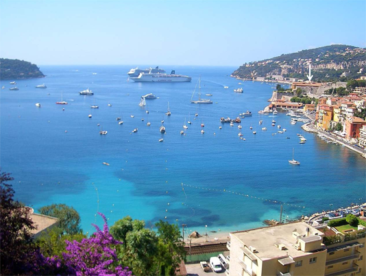 The SLS started in 2012 and has been coordinated by David Antoine and hosted at the Laboratoire d’Océanographie de Villefranche (LOV) in France from its inception. The IOCCG is very grateful to David for the tremendous effort to coordinate the SLS from 2012-2023, to LOV, the home of the SLS for the past 10 years, past SLS sponsors, and to the many dedicated volunteer lecturers and staff throughout the 10-year history.
The IOCCG Project Office is now accepting expressions of interest for a new volunteer coordinator for the SLS. The coordinator must be associated with a viable host institution to carry the SLS forward for another decade. See the full description and institution requirements. EOIs should be submitted to the IOCCG Project Coordinator, Raisha Lovindeer by email at raisha@ioccg.org. The deadline for submission of EOIs is 31 May 2023.
News from NASA
Geostationary Littoral Imaging and Monitoring Radiometer
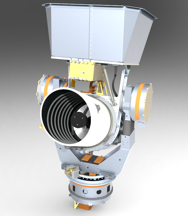
source: Raytheon Company
NASA’s Geostationary Littoral Imaging and Monitoring Radiometer (GLIMR) program recently completed its Key Decision Point-C (KDP-C) milestone and is formally confirmed to transition from the Program Formulation phase into Program Implementation. Successful completion of this extensive review process, which began with a preliminary design review in mid-2022, represents authorization from the NASA Headquarters Science Mission Directorate (SMD) to proceed into program Phase C, which entails final design and fabrication of the GLIMR instrument.
GLIMR, NASA’s newest ocean color mission, is an Earth Venture Instrument Project managed by the University of New Hampshire (UNH) and led by Principal Investigator Dr. Joseph Salisbury at UNH with a team of leading university scientists, NASA Goddard Space Flight Center, NOAA and EPA. The NASA Earth System Science Pathfinder Program (NASA Langley) provides mission oversight. Raytheon Intelligence and Space is developing and building the GLIMR instrument payload which features a hyperspectral radiometer with key instrument capabilities that include more than 250 spectral channels spanning the range from 340 nm to 1040 nm, 300 m ground sampling at nadir, and near-hourly revisit of geographical regions of interest. GLIMR’s planned geostationary orbit is at West Longitude 98°.
GLIMR is poised to provide groundbreaking ocean color science data from a geostationary orbit and fills significant gaps in the current suite of ocean color sensors. Current NASA ocean color missions cannot provide GLIMR’s combination of temporal, spectral and spatial resolution necessary to understand short term processes in dynamic coastal waters. GLIMR data will quantify biological and biogeochemical processes, track carbon inventories in time and space, and examine impacts of tides, surface currents, and river discharge on distribution and fluxes of ocean materials. GLIMR will also provide federal, state, and local agencies with vital information on coastal hazards such as oil spills and harmful algal blooms (HABs), allowing improved response, containment, and public advisories both at sea and along the coast.
4th Issue of the PACE Community Newsletter
Read about all-things-PACE as the mission prepares for launch in the newest issue of the PACE Community Newsletter
News from NOAA
NOAA CoastWatch & Partners tracking Sargassum blooms develop FAQ

The University of South Florida’s Alternative Floating Algae Index is used as a core input to analyze coastal areas at a resolution of 50km per pixel. Sargassum inundation risk is then classified. Image from aoml.noaa.gov/obs-for-blue-economy/#sargassum
Researchers at NOAA CoastWatch and NOAA Atlantic Oceanographic & Meteorological Laboratory (AOML) alongside the University of South Florida (USF) developed the experimental Sargassum Inundation Report (SIR) to provide an overview of the extent of Sargassum in the ocean and the risk of Sargassum washing into coastal waters, beaches, and shorelines in the Caribbean, Gulf of Mexico, and southeast Florida regions. Research conducted at NOAA in partnership with the University of Miami, USF, and LGL Ecological Research (TX) is also aiding to identify how Sargassum extends across the Caribbean, Gulf of Mexico, and tropical Atlantic, by assessing the role of ocean currents, winds, and waves in their motion. This work includes field experiments conducted to monitor the actual path of Sargassum using satellite tracking devices, surface drifters, satellite imagery, and physical representation of Sargassum in theoretical and numerical simulations.
Recently, frequently asked questions (FAQs) for Sargassum was composed by the AOML in partnership with NOAA CoastWatch Caribbean, Gulf of Mexico and Atlantic OceanWatch Node. Visit the AOML-hosted Sargassum FAQ page for additional context on Sargassum research, tracking and monitoring, including links to reports on weekly sargassum inundation risk.
NOAA CoastWatch Annual Science Meeting
The NOAA CoastWatch Annual Science Meeting will be held May 22-25, 2023 in Honolulu, HI, hosted by the OceanWatch Central Pacific Node (housed in the NOAA/NMFS Pacific Islands Fisheries Science Center) at the University of Hawaii campus. This meeting will feature Central Pacific Node stakeholders and associated research, applications development, and products tailored to meet user needs.
New NOAA OC Science Team Publications added to the IOCCG Bibliography
- Shi, W. and M. Wang, (2023) Synchronous in chlorophyll-a and sea surface salinity variability in the Equatorial Pacific Ocean, IEEE J. Sel. Topics Appl. Earth Observ. Remote Sens., 16, 2808–2818. doi:10.1109/jstars.2023.3255179
- Hu, C., L. Qi, L. Hu, T. Cui, Q. Xing, M. He, N. Wang, Y. Xiao, D. Sun, Y. Lu, C. Yuan, M. Wu, C. Wang, Y. Chen, H. Xu, L. Sun, M. Guo, and M. Wang,. (2023) Mapping Ulva prolifera green tides from space: A revisit on algorithm design and data products, Int. J. Appl. Earth Obs. Geoinf., 116, 103173. doi:10.1016/j.jag.2022.103173
- Hu, C., L. Qi, D.C. English, M. Wang, K. Mikelsons, B.B. Barnes, M.M. Pawlik, and D. Fick,. (2023) Pollen in the Baltic Sea as viewed from space, Remote Sens. Environ., 284, 113337. doi:10.1016/j.rse.2022.113337
Upcoming Events
The Third International Operational Satellite Oceanography Symposium (OSOS-3)
The final day to register for the Third International Operational Satellite Oceanography Symposium (OSOS-3) is 12 May 2023. OSOS-3 will be held from 12 – 16 June 2023, in Busan South Korea. The symposium aims to feature research and applications in Asia, the Pacific (including small Island nations), and high-latitudes. There will be a focus on engaging users on requirements and priorities, demonstrating the use of satellite data in coupled numerical models and emphasising socio-economic benefits from Earth Observation.
May 12 is also the last day to book with the meeting venue hotel at the discounted rate, as well as to request a letter of invitation for a Korean travel visa via email. Meeting sessions will be held from 12 – 15 June, and an optional training day (now closed for registration) on 16 June 2023. The event is co-sponsored by NOAA, EUMETSAT and KHOA. OSOS-3 has been endorsed as an official event of the UN Ocean Decade.
Call for Abstracts open for the Sentinel-3 Validation Team Meeting 2023 (S3VT), 5-7 December 2023, Darmstadt, Germany
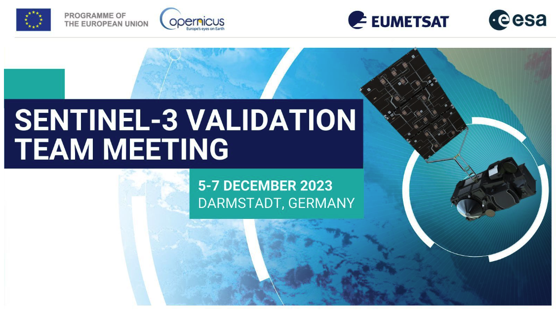 The 8th Sentinel-3 Validation Team (S3VT) meeting will be hosted by EUMETSAT and co-chaired with ESA and will take place 5-7 December 2023 in Darmstadtium, Darmstadt, Germany.
Call for abstracts is open with the deadline 31 May 2023. Abstracts can be submitted online through the meeting website.
Registration deadline is 5 November 2023.
For more information, please visit the meeting website https://www.eventsforce.net/s3vt2023 or contact the organizers at s3vtm@eumetsat.int.
They are looking forward to seeing you in Darmstadt in December!
4th Workshop on HPLC Phytoplankton Pigments Inter-comparisons (HIP), 12-13 July 2023 at JRC, Ispra, Italy
The 4th Workshop on HPLC Phytoplankton Pigments Inter-comparisons (HIP) will take place 12 – 13 July 2023 at the Joint Research Centre of the European Commission in Ispra, Italy, and will be a hybrid event. The event is an opportunity to create and expand a network of researchers whose activities focus on marine and freshwater pigments analysis to support satellite data and bio-optical algorithm validation. The aim of this workshop is to present and discuss the results of the last HPLC phytoplankton pigment analysis (HIP-7) and to plan future inter-comparison activities. Participation in the 4th HIP Workshop is limited to a total of 30 participants. Registration for the event is free of charge.
Click here for details or contact the organizer at JRC-HIP-workshop@ec.europa.eu.
Trends, Reflections, Evolution, and Visions in Ocean Research, 9-11 August 2023, Plymouth Marine Lab, UK
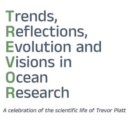 Registration is open for the Trevor Platt Science Foundation (TPSF) and partners inaugural science symposium from 9 -11 August 2023, at the Plymouth Marine Laboratory (PML), UK: Trends, Reflections, Evolution, and Visions in Ocean Research – a celebration of the scientific life of Trevor Platt. The symposium will include keynote and invited lectures, oral and poster presentations, and networking sessions. The final day to register is 30 June 2023. See the symposium page on the TPSF website for details.
An associated in-person training course, Satellite-based tools for investigating aquatic ecosystems, will be held from 7-8 August 2023. An online component of the training session is currently being delivered every Wednesday until July 26. Registration for the online training is free, on-going, and open to all.
Featured Publications
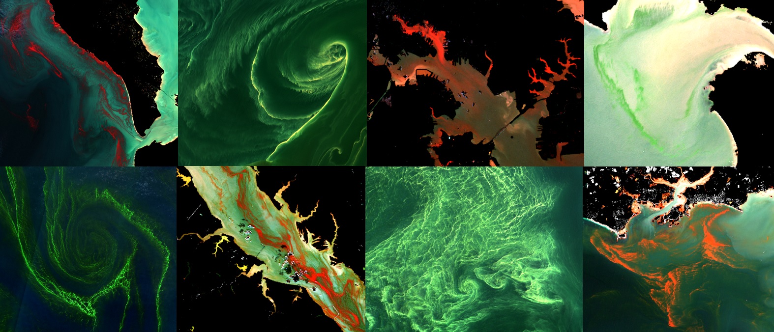 Gernez et al. (2023) published a spectral library of >100 highly concentrated blooms worldwide using an original combination of in situ monitoring data together with Sentinel-2 high spatial resolution remote sensing. Six optical bloom types with distinct reflectance shapes could be discriminated. In particular, massive blooms dominated by three species could be fingerprinted: red tides of Mesodinium rubrum (a phycoerythrin-bearing mixotrophic ciliate), green seawater discolorations caused by Lepidodinium chlorophorum (a dinoflagellate with an unusual carotenoid composition), and surface aggregations of the red Noctiluca scintillans (a purely heterotrophic dinoflagellate devoid of chlorophyll a). Amongst the other optical bloom clusters, dense surface accumulations of buoyant microalgae (such as cyanobacteria, or the green N. scintillans) could be distinguished from other types of phytoplankton blooms.
The last two optical bloom types, which were taxonomically and spectrally more diverse, corresponded to blooms essentially dominated by a dinoflagellate (such as Lingulodinium polyedra or Karenia brevis), a prymnesiophyte (Phaeocystis sp.) or a pelagophyte (Aureococcus anophagefferens). By providing a comprehensive assessment of the reflectance variability underlying the many shades of red tides worldwide, this study demonstrates Sentinel-2 ability to detect highly concentrated phytoplankton blooms, and offers original perspectives for harmful algal blooms observation.
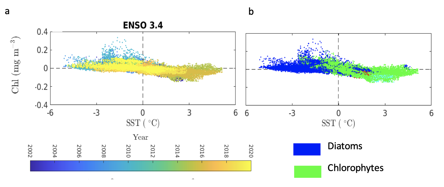
the relationship between compound chlorophyll (Chl) and sea surface temperature (SST) anomalies (left panel) and phytoplankton group dominance (right panel) in the ENSO 3.4 region.
Marine heatwaves have become recurrent throughout the oceans and are expected to increase in intensity relative to historic norms. Among the ecological ramifications associated with these high temperature anomalies are increased mortality of higher trophic organisms such as marine mammals and seabirds, which are likely triggered by changes in the composition of phytoplankton, the base of the marine trophic food web. Arteaga and Rousseaux (2023) assimilated satellite ocean color data into an ocean biogeochemical model to describe changes in the abundance of phytoplankton functional types (PFTs) during the last two decade’s warm anomalies in the equatorial and northeastern Pacific Ocean. They found important changes associated with the “Blob” warm anomaly in the Gulf of Alaska, where reduced silica supply led to a switch in community composition from diatoms to dinoflagellates, resulting in an increase in surface ocean chlorophyll during the Summer–Fall of 2014. A more dramatic change was observed in the equatorial Pacific, where the extreme warm conditions of the 2016 El Niño resulted in a major decline of about 40% in surface chlorophyll, which was associated with a nearly total collapse in diatoms. As extreme El Niño events become more frequent and potentially more acute, the phytoplankton community composition could shift more permanently towards groups associated with less efficient productivity, transfer, and export of organic carbon to depth. In the figure, large phytoplankton cells (diatoms) dominate the regime of low-SST and high-Chl anomalies, while smaller cells, better acclimated to low-nutrient environments (chlorophytes), dominate the opposite extreme of compound high-SST and low-Chl anomalies.
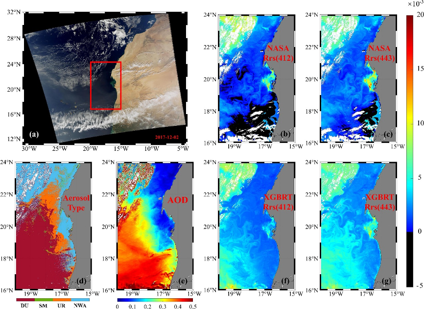 Atmospheric correction of ocean color remote sensing is affected by the vertical distribution of absorbing aerosol, which leads to great uncertainties of remote sensing reflectance (Rrs) in coastal and inland waters, especially for ultraviolet or blue bands. Song et al. (2023) proposed an atmospheric correction algorithm (OC-XGBRT) to retrieve Rrs(λ) at short wavelength bands of visible light in the presence of absorbing aerosols, while considering their vertical distributions. In the previous studies, the prediction model of vertical distribution of absorbing aerosol (Song et al., 2020) and the absorbing aerosol model (Song et al., 2022) were constructed, which can quantitatively estimate the vertical distribution of absorbing aerosol. The reflectance at the top of atmosphere and Rrs were simulated considering multiple types of absorbing aerosols (dust, smoke, and urban aerosols) and their vertical distribution under the comprehensive aquatic environment. Based on the extensive simulation dataset, the OC-XGBRT algorithm was established using a machine learning method. The performance of the OC-XGBRT algorithm was validated by in situ datasets from the SeaBASS and AERONET-OC, as well as applications to MODIS-Aqua data. Results revealed that the OC-XGBRT algorithm substantially improved the quality of the retrieved Rrs at blue light bands compared with the original Rrs products in the presence of absorbing aerosols.
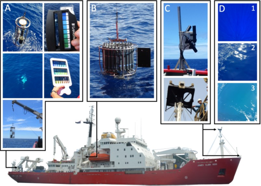
Instrumentation used on-board the RRS James Clark Ross. See full description in Fig. 2 of the paper.
In view of obtaining the longest optical time series of the oceans, historic optical variables such as Secchi depth (zSD) and Forel-Ule colour need to be linked to modern radiometry and chlorophyll-a concentration (Chl-a). Brewin et al. (2023) analyzed coincident measurements of all these variables that were collected on four Atlantic Meridional Transect (AMT) cruises (Figure below). Historic and modern optical measurements were broadly consistent with current understanding, with Secchi depth inversely related to Forel-Ule colour and to beam and diffuse attenuation, positively related to the ratio of blue to green remote-sensing reflectance and euphotic depth. Chl-a was tightly correlated with these optical variables, with the ratio of blue to green remote-sensing reflectance explaining the highest amount of variance in Chl-a (89%), closely followed by the Secchi depth (85%) and Forel-Ule colour (71-81%, depending on the scale used). Existing algorithms that predict Chl-a from these variables were evaluated, and found to perform well, albeit with some systematic differences. Remote sensing algorithms of Secchi depth were in good agreement with in-situ data over the range of values collected, but with a slight positive bias. Remote sensing algorithms of Forel-Ule agreed well with Forel-Ule colour data of infinite water. The high quality of the data evidenced some second-order impact of environmental conditions. In particular, wind speed was found to impact the estimation of zSD, and a mechanistic incorporation of such effect into current Secchi depth theory was proposed. The paper wraps up with a discussion of the benefits and challenges of collecting measurements of the Secchi depth and Forel-Ule colour, and future directions for research are proposed. The dataset is made publicly available to support the research community working on the topic.

Example of Ulva prolifera detection from GF-4 images. See full figure and description in Fig 3 of the paper.
Automatically detecting macroalgae from optical remote sensing images has been a long-standing problem in ocean monitoring. Pan et al., (2023) develop the unsupervised classification method named Context-Sensitive Level Set (CSLS) taking the ecological indicator of NDVI as input by exploiting a region-based level set driven by context-sensitive energy function for macroalgae detection from optical remote sensing images. Quantitative and qualitative evaluations based on satellite optical images with various imaging time and spatial resolutions (16-250m) from GF-1, GF-4, Landsat-8, and Aqua demonstrate the effectiveness and robustness for Ulva prolifera detection. The model is proved to be superior to the traditional NDVI thresholding method and state-of-the-art level set methods in terms of higher accuracy (Kappa coefficients 0.87~0.92) and automation (without artificial threshold/parameter adjustment). Moreover, the model has the advantage of accommodating complex environmental conditions (such as different water turbidity, thin clouds and sun glint), and can be utilized for detection of Sargassum bloom. The CSLS source codes and the dynamic evolution results of the multi-source optical remote sensing image samples are at the link https://github.com/DongdongMeng/The_CSLS_model.
New Software & Datasets
The following datasets have been added to the Satellite and In Situ Data section and Software section on the IOCCG website, respectively:
- The GLORIA dataset (GLObal Reflectance community dataset for Imaging and optical sensing of Aquatic environments) and data descriptor
- Code for the LS2 inverse model (Loisel et al., 2018) aimed at estimating the absorption and backscattering coefficients
- LS2 code on Github
- Kd Neural Network (MODIS Bands)
The following datasets have also been added to the Datasets Bibliography linked to the Task Force on Remote Sensing of Marine Litter & Debris (RSMLD).
Employment Opportunities
Several new research and employment positions were added to Employment Opportunities section on the IOCCG website including:
- 3-year PhD Fellowship Position in Remote Sensing of Water Quality, LOG, France
- Senior Climate Applications Scientist – Oceanography, ESA, ECSAT, UK
- Two Earth Observation Remote Sensing Scientists at Plymouth Marine Lab, UK
- 2-year Postdoctoral Position in Biogeochemical Oceanography at Laboratoire d’Océanographie de Villefranche (LOV), France
- Lecturer in Marine Remote Sensing at the University of Plymouth, UK
- Satellite Data Analyst/Scientist at The Royal Belgium Institute of Natural Sciences, Brussels, Belgium
Click here For more information on these and other positions.
If you would like to include a position on this page, please contact Raisha Lovindeer.
