The IOCCG news bulletins include news from the IOCCG, its sponsoring agencies, and the broader ocean colour community. If you would like to submit an item of interest for the next IOCCG news bulletin, please contact Dr. Raisha Lovindeer, with a cc: to Dr. Venetia Stuart. If you are having trouble receiving email notifications from IOCCG, please see instructions on how to Whitelist “Campaign Monitor” (the IOCCG email marketing platform). Please also add the ioccg.org domain to your safe list (especially important for subscribers with Gmail accounts – also check your SPAM folder). You can also follow IOCCG on Twitter.
IOCCG News
Protocols for Particulate Organic Matter Sampling and Measurement Published
 The final version of the protocol document entitled “Particulate Organic Matter Sampling and Measurement Protocols: Consensus Towards Future Ocean Color Missions” is now available for download from the IOCCG website at: https://ioccg.org/wp-content/uploads/2021/08/protocols-pom-v6.0.pdf.
This document is the product of a NASA-supported workshop to produce community consensus protocols for sample collection, filtration, storage, analysis, and quality assurance for particulate organic carbon in all natural waters, emphasizing marine ecosystems, appropriate for satellite algorithm development and validation. Given the close link between global cycles of carbon and nitrogen and that current analytical protocols usually are geared towards their simultaneous measurement, recommendations for analysis of nitrogen in particles are also included. The hope is that the protocols presented here can be widely adopted by the academic scientific community engaged in aquatic C and N cycle research, particularly in activities that support ocean color validation.
Draft Protocols for Measuring Primary Productivity
A draft version of the protocol entitled “Aquatic Primary Productivity Field Protocols for Satellite Validation and Model Synthesis“ is now available on the IOCCG website for community feedback, with a closing deadline for comments of 10 November 2021. This document is part of the field measurement protocol series – IOCCG Ocean Optics & Biogeochemistry Protocols for Satellite Ocean Colour Sensor Validation. We welcome your comments on this protocol document – please send to pp_comments@oceancolor.gsfc.nasa.gov before the deadline.
Background: In 2018, a working group sponsored by the NASA Plankton, Aerosol, Cloud, and ocean Ecosystem (PACE) project, in conjunction with the IOCCG, EUMETSAT, and JAXA, was assembled with the aim to develop community consensus on multiple methods for measuring aquatic primary productivity used for satellite validation and model synthesis. A workshop to commence the working group efforts was held December 05-07, 2018 at the University Space Research Association headquarters in Columbia, MD U.S.A., bringing together 26 active researchers from 16 institutions. In this document, the authors discuss and develop the findings of the workshop as they pertain to measurements of primary productivity, including the essential issues, nuances, definitions, scales, uncertainties, and ultimately best practices for data collection across multiple methodologies.
2022 IOCCG Summer Lecture Series
The 5th edition of the advanced IOCCG Summer Lecture Series is scheduled for 18-29 July 2022 in Villefranche-sur-Mer (if global travel restrictions have been lifted by that time). The course will be held at the Laboratoire d’Océanographie de Villefranche (LOV), which is part of the IMEV (Institut de la Mer, de Villefranche), and hosts the Marine Optics, Remote Sensing, and Biogeochemical Applications group. As in previous years, this high-level training course will be dedicated to the fundamentals of ocean optics, bio-optics and ocean colour remote sensing. Several eminent scientists will provide lectures on cutting edge research, and students will have ample opportunity to meet with the lecturers for in-depth discussions on various pre-selected topics, as well as on their own scientific research. Application for the Summer Lecture Series will open in January 2022 via the IOCCG Summer Lecture Series website.
News from NASA
PACE Applications Workshop
On September 15-16, the NASA PACE mission hosted the 2nd PACE Applications Workshop. Over 720 participants from over 70 counties registered. Attendees shared information about PACE applications, identified advanced and exploratory PACE products, and discussed opportunities and challenges in PACE user communities. The workshop featured live panel discussions with members of the PACE air quality, water quality, and capacity building communities. All session recordings are available here.
PACE Science and Applications Team Meeting
The 3-day PACE Science and Application Team Meeting was held at the University of Connecticut, Avery Point in a hybrid format with 32 in-person attendees and 77 virtual attendees. This meeting was the 2nd annual PACE Science and Application Team Meeting and corresponds to the researchers entering their second year of funding.
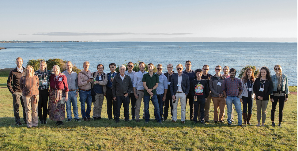
Some attendees of the PACE Science & Application Team Meeting
Twenty-two in-person and twenty-eight virtual presentations were given, including 5-min lightning talks from each science and application team member, 30-min mission and instrument updates from the PACE project office and engineering teams, 15-min presentations from the six topical science team working groups, and 20-min presentations from the two vicarious calibration teams. Three breakout group sessions were held on thematic areas, including characterizing uncertainties, identifying gaps, and validating data products.
The hybrid meeting format facilitated a best-of-both-worlds opportunity to collaborate, to resolve sticking points, and to build partnerships, while sharing mission and programmatic updates and while advancing the science and societally relevant applications of the PACE mission. Presentations from the meeting will be available here.
UN Decade of Ocean Science for Sustainable Development
UNESCO endorsed the PACE mission as a Decade Action contribution to the UN Decade of Ocean Science for Sustainable Development (https://www.oceandecade.org/). PACE will specifically contribute to the Decade Challenges of expanding the global ocean observing system, creating a digital representation of the ocean, and enhancing skills, knowledge and technology for all. Link to PACE Mission contribution at OceanDecade.org.
PACE is one of a few Decade Actions dedicated to Earth Observations, along with the Committee on Earth Observation Satellites (CEOS) COAST (Coastal Observations, Applications, Services, and Tools), also listed as a Decade Action contribution to the UN Decade of Ocean Science for Sustainable Development.
News from NOAA
The 7th dedicated JPSS VIIRS Ocean Color Cal/Val Cruise
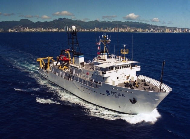
NOAA Ship Oscar Elton Sette underway off Honolulu, Hawaii. NOAA image.
The 7th dedicated JPSS VIIRS Ocean Color Cal/Val Cruise is now scheduled for ~12 days at sea from 7 March to 18 March 2022 going in and out of Honolulu on the NOAA Ship Oscar Elton Sette. The crew will include approximately 20 scientists. The primary purpose is to validate JPSS VIIRS and other ocean color satellites that NOAA and partner agencies utilize. A secondary goal for this cruise is to conduct a characterization and validation of MOBY and the new NOAA MOBY Refresh during their anticipated crossover period. They plan to spend as many days necessary to gather good clear sky validations of the two buoys and characterization of the waters surrounding the area. In addition, they will be conducting intercomparisons of validation measurements for both radiance and derived products and collecting a full suite of measurements for algorithm development.
The report on the 6th VIIRS cal/val cruise from Pascagoula during April 2021 in the Gulf of Mexico is currently in progress. Previous NESDIS Technical Reports on the Dedicated JPSS VIIRS Ocean Color Calibration/Validation Cruise Series: Report #154 (September 2019); Report #152 (May 2019); Report #151 (October 2016); Report #148 (December 2015); Report #146 (November 2014).
NOAA CoastWatch/OceanWatch/PolarWatch Program Annual Science Meeting

Screenshots from virtual NOAA CoastWatch annual science meeting.
The NOAA CoastWatch/OceanWatch/PolarWatch Program (“CoastWatch”) held its annual science meeting September 27-30, 2021, hosted virtually by the East Coast Regional Node. CoastWatch Central Operations, six Regional Nodes, and the Research and Applications team convened with data users and scientists on the progress of current projects, the needs of the user community, new satellite data products including those from upcoming satellite missions, and the status of applications and tools for meeting environmental concerns. Satellite data users presented on the environmental issues they face and their needs for satellite data, such as commercial aquaculture farmers and state health agencies and local community groups monitoring algal blooms. Technical sessions focused on transitioning to the cloud, as well as new developments in the CoastWatch satellite data training efforts.
Geostationary Extended Observations (GeoXO) Program
 The Geostationary Extended Observations (GeoXO) program was formally approved to begin the technology and development phase of the mission, ” Phase A”, on July 21, 2021. The joint NOAA/NASA Agency Program Management Council affirmed the program addresses a critical need and the proposed mission concept is feasible. During Phase A, the GeoXO Program will develop the final mission concept, system-level requirements, necessary system technology developments, and program/project technical management plans. The GeoXO Ocean Color (OCX) Phase A Study Request for Proposals has been released.
Recent Peer Reviewed Publications from NOAA OC Science Team
Mikelsons, K. and M. Wang, “Global clear sky near-surface imagery from multiple satellite daily imagery time series”, ISPRS Journal of Photogrammetry and Remote Sensing, 180, 238-254 (2021). doi:10.1016/j.isprsjprs.2021.08.013
Miller, S. D., S. H. D. Haddock, W. C. Straka, III, C. A. Seaman, C. L. Combs, M. Wang, W. Shi, and S. Nam, “Honing in on bioluminescent milky seas from space”, Sci. Rep., 11, 15443 (2021). doi:10.1038/s41598-021-94823-z
Wei, J., M. Wang, L. Jiang, X. Yu, K. Mikelsons, and F. Shen, “Global estimation of suspended particulate matter from satellite ocean color imagery”, Journal of Geophysical Research: Oceans, 126, e2021JC017303 (2021). doi:10.1029/2021JC017303
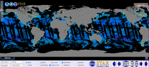
Global map of suspended particulate matter as reported in Wei, et al. 2021, shown in OCView, the NOAA/STAR Ocean Color Team online viewing tool. The URL linked from this figure links to the online image.
Korea National Ocean Satellite Center (NOSC)
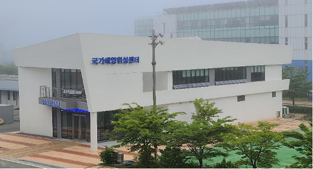
National Ocean Satellite Center (NOSC), Republic of Korea
The National Ocean Satellite Center (NOSC) was established in May 2019 under the Korea Hydrographic and Oceanographic Agency (KHOA) of the Ministry of Oceans and Fisheries, Republic of Korea, to promote national ocean satellite policy and provide reliable ocean satellite data. NOSC has been collecting a wide range of satellite data by operating the Geostationary Ocean Color Imager II (GOCI-II mounted on GEO-KOMPSAT 2B) launched in February 2020, and is providing scientific data necessary for marine activities by the public, and responses to climate change, using various global satellites.

GEO-KOMSAT 2B satellite
GOCI-II acquires data 10 times per day in 13 spectral bands with a spatial resolution of about 250 m over the Korean Sea, and provides a wide range of data products including the concentration of chlorophyll and suspended matter for monitoring changes in water quality in coastal waters (including red tides) as well characteristics of marine aerosols. GOCI-II data (pre-processing standard data) are available free of charge to the public and can be downloaded from the KHOA website (currently only available in Korean. KHOA will complete the English website shortly). NOSC also plans to expand Korea’s ocean satellite infrastructure including the development of a subsequent geostationary orbit satellite and polar orbit satellites, and will also participate in international cooperation.
Harnessing Satellites for Water
 Read the interesting and informative blog by Blake Schaeffer, Scientist at US EPA.
Satellites can provide a wide range of water quality measures such as temperature, light attenuation, oil slicks, organic matter, chlorophyll, turbidity, and benthic habitat type (IOCCG Report 17). Research and practical applications have evolved and quickly improved with newer satellite technologies including operational missions such as the European Sentinels, 2-5m resolution commercial missions, and new/upcoming hyperspectral missions, such as the NASA PACE and GLIMR missions.
Across the US, there are field measurements of water temperature for more than 11,000 lakes (data available in the Water Quality Portal). The Landsat (30m spatial resolution) satellite substantially increases the number of lakes to more than 170,000 lakes across the US. That number doesn’t even include measurements from rivers and estuaries! By the way, Landsat surface temperature data is freely available at the USGS Earth Explorer website.
A recent study on potential annual cost savings looked at the satellite monitoring of chlorophyll from the European Space Agency Sentinel-3 and NASA and USGS Landsat satellites was between $5.7-$316 million just for lakes! Also, satellite data used in recreational early warning systems have been shown to save $360,000 in a single advisory case study. That is huge! Satellites span political and geographic boundaries, provide an opportunity for systematic approaches to better target discrete sampling, and a more comprehensive spatial and temporal context. Within this scenario, IWA can help to widen the use of these products in the water industry and ensure they are universal and accessible. Read more…
News from GEO AquaWatch
Call for Early Career Scientists
 GEO AquaWatch is seeking early career water quality scientists as leaders for working groups, to develop and lead activities which attract and engage other early career scientists, and to be participants in the GEO AquaWatch Initiative. Graduate students, post-docs, and new faculty are especially encouraged to fill leadership roles in any of the GEO AquaWatch working groups. Email mbneely@geoaquawatch.org with Early Career in the subject line, if you’d like to volunteer for a leadership role.
GEO AquaWatch New Project Showcase Videos
Short 9-12 min presentations on five new water quality projects from around the world are now available here, on the Group on Earth Observations YouTube page. These presentations are the final installment of a 4-part informational series by GEO that began in March 2021.
Visit this link for information on future GEO AquaWatch webinars.
Canadian NetCOLOR
 The network of Canadian experts and end-users in the field of aquatic color remote sensing (NetCOLOR) has just launched a new website. NetCOLOR, established in 2014 in collaboration with the Canadian Space Agency, provides a means for Canadian researchers and other people working in the field of aquatic remote sensing to create an efficient and united centre of expertise through the development of a national strategy for research, training and dissemination of water colour products. The new website allows the international community to keep updated on Canadian regional activities in aquatic remote sensing, and contains links to all videos and PDFs from past National NetCOLOR meetings (including the immediate past meeting in March 2021), as well as other reports and publications.
Trevor Platt Science Foundation
![]() The inaugural meeting of the Trevor Platt Science Foundation (TPSF) took place on 12 August 2021, Prof Platt’s birthday, with many of his former students and colleagues from around the globe in attendance. The Foundation, based in Kochi, India, was established to carry forward the legacy of Prof. Trevor Platt and honour his ideas on scientific research and capacity building. Participants shared fond memories of Trevor as well as suggestions on how to steer the foundation forward. The Foundation welcomes new members – please register via the TPSF Registration Form. Prof. Platt played an enormous role in the establishment of the IOCCG, being one of the founding members of the group, and serving as the first Chairman for a period of 10 years (from 1996-2006). A website for the Foundation is currently under construction.
The inaugural meeting of the Trevor Platt Science Foundation (TPSF) took place on 12 August 2021, Prof Platt’s birthday, with many of his former students and colleagues from around the globe in attendance. The Foundation, based in Kochi, India, was established to carry forward the legacy of Prof. Trevor Platt and honour his ideas on scientific research and capacity building. Participants shared fond memories of Trevor as well as suggestions on how to steer the foundation forward. The Foundation welcomes new members – please register via the TPSF Registration Form. Prof. Platt played an enormous role in the establishment of the IOCCG, being one of the founding members of the group, and serving as the first Chairman for a period of 10 years (from 1996-2006). A website for the Foundation is currently under construction.
Journal Special Issues
Remote Sensing of Inland, Coastal and Oceanic Waters
 A call for papers for a Special Issue on Remote Sensing of Inland, Coastal and Oceanic Waters (International Journal of Applied Earth Observation and Geoinformation) has been released (submission deadline: 31 December 2021; planned publication date: Summer 2022). This special issue is to collect novel research that employs remote sensing approaches to determine spatial and temporal dynamics of aquatic ecosystems and water extent/stage/storage. This includes, but is not limited to: new satellite instrument evaluation and applications, atmospheric correction, machine learning approaches, ocean color/watercolor retrievals, water quality monitoring and prediction, dissolved, particulate carbon estimation, aquatic vegetation mapping and monitoring, water boundary and dynamic analysis, estimation of water budget, other relevant research to aquatic remote sensing.
Reliable Detection of Water Quality and Aquatic Ecosystem Dynamics in Inland Waters
![]() A call for papers for a Special Issue on Reliable Detection of Water Quality and Aquatic Ecosystem Dynamics in Inland Waters (Remote Sensing, section: Environmental Remote Sensing) has been issued. The Special Issue focuses on remote sensing approaches dedicated to freshwater ecosystems and inland water quality. While numerous case studies are available on the wide potential offered by remote sensing, maximizing this potential for reliable and large-scale application of remote sensing techniques to surface water monitoring programmes demands going beyond case study research. Papers that go beyond a simple assessment of the current state of a given aquatic ecosystem and derive key dynamic features in intra- and inter-annual timescales, further understand drivers of water quality phenomena and implications for water resource management and decision-making, are welcome. Finally, contributions that improve our mechanistic understanding of ecosystem functioning by linking sensor signals to in situ variables and aquatic ecosystem dynamics, as well as innovations in sensor development or indicator variables are highly welcome. The submission deadline is 31 May 2022.
A call for papers for a Special Issue on Reliable Detection of Water Quality and Aquatic Ecosystem Dynamics in Inland Waters (Remote Sensing, section: Environmental Remote Sensing) has been issued. The Special Issue focuses on remote sensing approaches dedicated to freshwater ecosystems and inland water quality. While numerous case studies are available on the wide potential offered by remote sensing, maximizing this potential for reliable and large-scale application of remote sensing techniques to surface water monitoring programmes demands going beyond case study research. Papers that go beyond a simple assessment of the current state of a given aquatic ecosystem and derive key dynamic features in intra- and inter-annual timescales, further understand drivers of water quality phenomena and implications for water resource management and decision-making, are welcome. Finally, contributions that improve our mechanistic understanding of ecosystem functioning by linking sensor signals to in situ variables and aquatic ecosystem dynamics, as well as innovations in sensor development or indicator variables are highly welcome. The submission deadline is 31 May 2022.
Upcoming Events
JKWOC/AWOC 2022 Workshop: 20-22, December, 2021
The 18th Japan-Korea, and the 9th Asian Workshop on Ocean Color (18th-JKWOC/9th-AWOC) will be held in 20-22, December, 2021, in an online space (Zoom and Gather.Town). Recent research activities and accomplishments from Asian countries will be presented, including the updates from national space agencies. The workshop particularly encourages presentations from students. Check out the details in the website (https://bit.ly/3vSoiAI).
Registration/Abstract due date : 15 November, 2021
Registration Link (no registration fee)
Ocean Carbon From Space Workshop: 14-18 February 2022
ESA, together with PML and support from NASA, is organising an Ocean Carbon From Space Workshop, to be held virtually, 14-18 February 2022. This workshop is being organised as the second workshop in the CLEO (Colour and Light in the ocean from Earth Observations) Series. It is a contribution to the Committee on Earth Observation Satellites (CEOS) Work Plan on the Aquatic Carbon Application area, as endorsed by the CEOS Ocean Colour Radiometry Virtual Constellation (OCR-VC) founded within IOCCG.
The main objectives of the workshop are to bring together remote sensing scientists, field scientists and modellers around the common topic of ocean carbon, its pools and fluxes, its variability in space and time and the understanding of its processes and interactions with the earth system. The aim is to articulate a collective view of the current status, identify gaps in knowledge and formulate the scientific roadmap for the next decade, with an emphasis on evaluating where Earth Observations (EO) may contribute.
The workshop is being organised as a series of sessions targeting specific themes. Each session will consist of invited talks, contributed oral and poster presentations, and a group discussion. The workshop will conclude with a synthesis and recommendation session. Read more details about the workshop, including information for submitting abstracts here.
2022 Ocean Sciences Meeting: 27 Feb – 4 March 2022
OSM 2022 has changed to a completely virtual format from February 27 – March 4, 2022. Sessions relevant to the ocean colour community include:
- CB04 PACE, GLIMR and SBG: Synergy across Future NASA Missions for Hyperspectral Remote Sensing of Coastal and Inland Waters
- CB05 Advancing Water Quality Monitoring and Forecasting in Coastal and Inland Waters
- CB15 Application of Remote Sensing to Societally Important Regions: Coastal, Estuarine, Tropical and Polar Waters
- CT07 Multidisciplinary insights into pathways of carbon export
- OB07 Research Opportunities from a Global Biogeochemical Argo Fleet
- OB27 Expanding Frontiers In Productivity and Flux from Ocean Optics
- OS11 Observing and Predicting the Global Coastal Ocean
- OT02 Ushering in a new era of hyperspectral and polarimetric radiometry for remote sensing of global ocean ecosystems
- OT08 Emerging Technologies and Techniques for Remote Sensing of Coastal and Inland Waters
Training Courses
- EUMETSAT Online Short Courses on data discovery for weather, oceanography, air quality and climate. Many of these courses are relevant to the ocean colour community.
- On-line workshop on Remote Sensing for Ocean-Atmosphere Interaction Studies and Applications, 1-3 December 2021.
New Publications
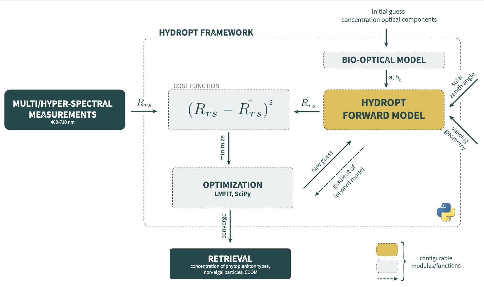 Holtrop & Van Der Woerd (2021) have developed a fast and flexible Python framework for forward and inverse modelling of multi- and hyperspectral observations from oceans, coastal and inland waters by further extending the formerly developed HydroLight Optimization (HYDROPT) algorithm. The remote sensing reflectance, Rrs , is calculated by specifying the inherent optical properties (IOP) of the water column, the sensor viewing geometry and solar zenith angle. The framework is based on radiative transfer principles and is sensor agnostic allowing for Rrs to be calculated for any wavelength in the 400 – 710 nm range. Inversion of Rrs spectra is achieved by minimizing the difference between the HYDROPT forward calculations and the reflectance measured by the sensor. Different optimization routines can be selected to minimize the cost function. An extensive description of the theoretical basis of the framework as well as applications are provided in Holtrop, T., & Van Der Woerd, H. J. (2021) and Van Der Woerd, H.J. & Pasterkamp, R. (2008). The software can be accessed at https://github.com/tadz-io/hydropt.
In another new publication, Pitarch & Vanhellemont (2021) point out that algorithm developers for high resolution sensors such as Landsat have often made redundant efforts by proposing empirical algorithms tuned with local data, with unknown applicability outside the calibration conditions, leading to algorithm proliferation and confusion among non-expert users. Instead, there is a need for algorithms with known uncertainties that have a clearly known and ideally wide range of applicability, in order to monitor many, potentially disconnected, water bodies with different optical characteristics that may lack in situ calibration data. In the marine optics community, efforts have been directed towards this, but unfortunately, knowledge transfer to the Landsat and inland water communities has been poor. Pitarch & Vanhellemont (2021) present a tool for semi-analytical IOP retrieval for this class of sensors, the “QAA-RGB”. It is an adaptation of Lee’s popular QAA to eighteen metre and decametre satellite sensors, including present and heritage Landsat, Sentinel 2 at 10 m, and an array of commercial satellites such as PlanetScope, Pléiades, and Worldview. The QAA-RGB retrieves bulk IOPs such as total absorption, particle backscattering, the diffuse attenuation coefficient, and the Secchi disk depth from remote-sensing reflectance at only three bands centred on red, green and blue wavelengths (RGB). Results show that, despite the limited spectral information, retrievals of non-water absorption at 555 nm (anw(555)) are satisfactory, with a standard deviation of ~ 50% up to anw(555)< 2 m-1, based on in situ datasets. Special attention has been dedicated to produce inter-sensor unbiased estimates by taking into consideration the respective relative spectral response functions. Notably, the QAA-RGB has been implemented in the open ACOLITE generic processor (see example retrievals in figure below). Standalone MATLAB scripts are also available in the Zenodo repository at https://doi.org/10.5281/zenodo.4923880.
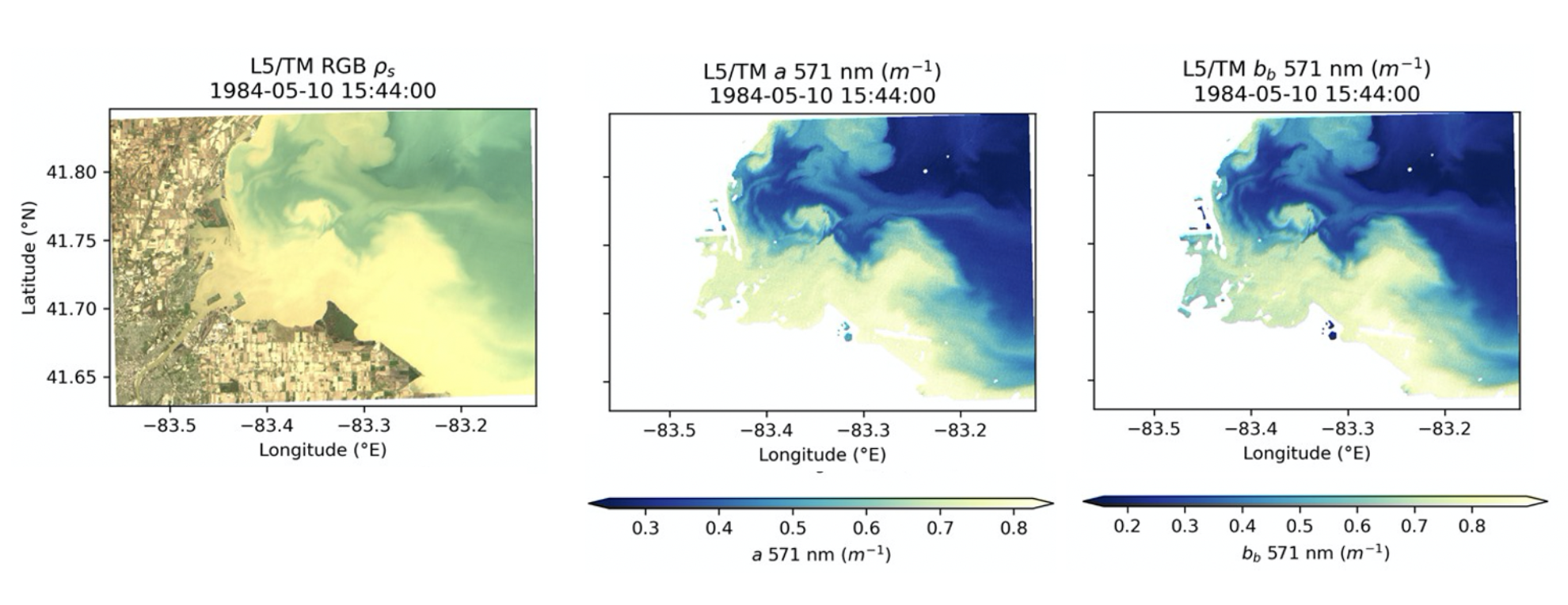
Application of the QAA-RGB to imagery from Landsat 5 over Lake Erie near Toledo (1984-05-10). From left to right: RGB composite, QAA-RGB absorption and QAA-RGB backscatter in the green band. Note the differences in the colour bars.

(left panel) MODIS:CALIOP bbp ratio (531nm) and MODIS:Argo bbp ratio (531nm) across the annual cycle in the South Pacific (~110W-140W, 20S). (right panel) MODIS:CALIOP and MODIS:MOBY bbp (531 nm) ratios for the MOBY site. The ratios exhibit unexplained seasonal variability.
In a novel study, Bisson et al. (2021) identified a seasonal bias in remote sensing reflectance (Rrs) across the SeaWiFS, MODIS-Aqua, and SNPP VIIRS sensors at the Marine Optical BuoY (MOBY) ocean color calibration site, as well as globally. The derived products from Rrs are seasonally biased as well, with particulate backscattering varying up to 50% over a year, chlorophyll varying up to 25% over a year, and absorption from phytoplankton or dissolved material varying by up to 15% compared to what is expected from in situ data. This has also been confirmed in comparison with lidar and sensors on profiling floats across different parts of the global ocean. The observed seasonal bias in Rrs is roughly symmetrical over the annual cycle (See Figure below showing bbp derived from Rrs), making it difficult to reconcile with known seasonal progressions in phytoplankton populations that tend to be asymmetric over the annual cycle. Seasonal symmetry is expected in properties directly dependent on solar geometry (atmospheric path length, day length, etc.). Therefore, the symmetric shape in Rrs over the annual cycle strongly implies that the seasonal bias likely reflects artifacts stemming from data processing. We have not yet identified the specific root cause of the seasonal bias in Rrs, but our current expectation is that it resides in one or more elements of the atmospheric correction (in particular the Bidirectional Reflectance Distribution Function (BRDF) correction) that are common to the processing of all ocean color sensor data. The bias is most pronounced in areas of low biomass and is not easily discernible in areas of high biomass, including coastal locations. Community contributions may help uncover the root cause of the bias. In the meantime, analyses of ocean color data should consider the potential influence of the seasonal bias in terms of interpreting results from Rrs.
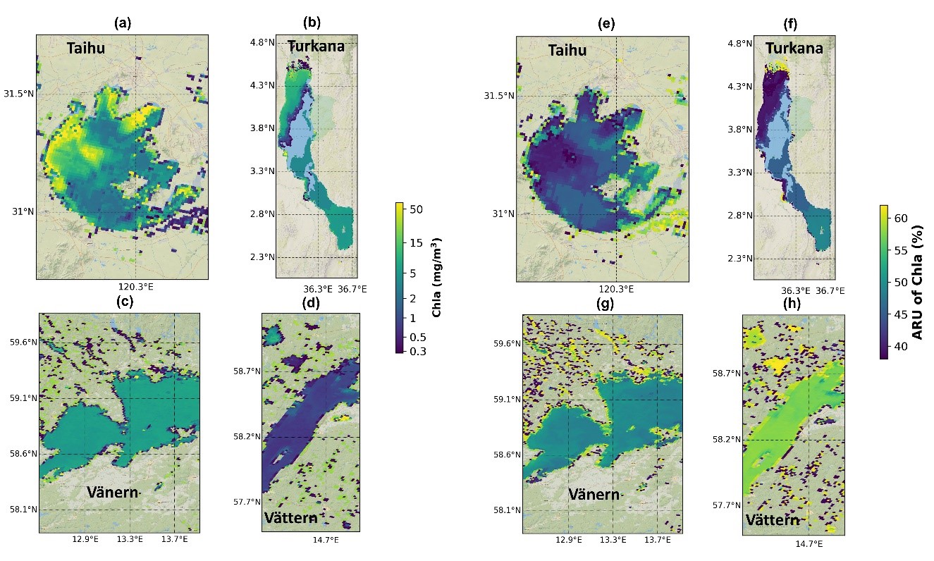
Example maps of the weighted-blended chlorophyll-a product and its per-pixel Absolute Relative Uncertainty in lakes (a and e) Taihu, (b and f) Turkana, (c and g) Vänern, and (d and h) Vättern, including any small water bodies in their vicinity.
Liu et al. (2021) have published a new research paper on retrieval of Chlorophyll-a concentration (Chla) and associated product uncertainty in optically diverse lakes and reservoirs. Satellite product uncertainty estimates are critical for the further development and evaluation of remote sensing algorithms, as well as for the user community (e.g., modelers, climate scientists, and decision-makers). As part of the Lakes_cci project (ESA Climate Change Initiative), the authors developed a method to produce estimates of Chla satellite product uncertainty on a pixel-by-pixel basis in an Optical Water Type (OWT) classification scheme, designed to dynamically select the most appropriate algorithms for each satellite pixel. Observations of Chla were related to 13 previously established OWT classes based on their corresponding water-leaving reflectance, each class corresponding to specific bio-optical characteristics. Uncertainty models corresponding to specific algorithm-OWT combinations for Chla were then expressed as a function of OWT class membership score. Embedding these uncertainty models into a fuzzy OWT classification approach for satellite imagery allows product uncertainty to be estimated for many different water types without directly relying on in situ data. Chla retrieval shows a generally robust response over a wide range of class memberships, indicating a wide application range (0.01 ~ 362.5 mg/m3) while allowing scientists to identify conditions where biogeochemical satellite retrieval algorithms require further improvement.
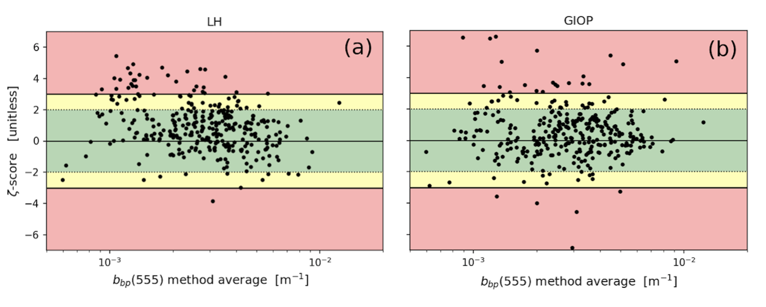
Zeta-score plots comparing modeled and observed bbp(555) varying with the method average values of bbp(555). Subplots a, b, correspond to the LH and GIOP models, respectively. The green, yellow, and red regions correspond to where acceptable, questionable, and poor agreement occur, respectively.
McKinna et al. (2021) have published a paper exploring how model and in situ observation uncertainties can be effectively incorporated into empirical ocean color algorithm development and assessment. The authors present updated metrics that account for measurement uncertainties and introduce new plots for improved visualization of algorithm performance. For this exercise, the authors focused on methods for deriving the particulate backscattering coefficient at 555 nm, bbp(555) (m−1), and developed a simple empirical algorithm for deriving bbp(555) as a function of a remote sensing reflectance line height (LH) metric.
Model training was performed using a high-quality bio-optical dataset that contains coincident in situ measurements of the spectral remote sensing reflectances, Rrs(λ) (sr−1), and the spectral particulate backscattering coefficients, bbp(λ). The LH metric used is defined as the magnitude of Rrs(555) relative to a linear baseline drawn between Rrs(490) and Rrs(670). Using an independent validation dataset, the authors compared the skill of the LH-based model with two other models and demonstrated that measurement uncertainties do indeed impact contemporary validation metrics such as mean bias and mean absolute error.

One-day averaged surface current in a 10 km-grid in the East/Japan Sea on 25th March 2018 derived from Himawari SST (a) and Himawari SST gradient (b) and corresponding scalar fields. 22 hourly velocity fields derived from 23 consecutive SST images were used to calculate the mean surface current for that date. The scattered cloud area accounted for about 68%, and the area excluding the cloud area was used to calculate the mean velocity field.
Lastly, Choi et al. (2021) proposed a strategy to derive and evaluate surface currents using geostationary satellite data, the Particle Image Velocimetry (PIV) method, and the deep learning convolutional neural network (CNN). Real-time surface current observation allows for investigating search and rescue at the site of a marine disaster, for example, and the surface movement and behavior of marine pollutants. Although the surface current can be mapped with HF radar, onboard instruments, satellite altimeters, and surface drifters, geostationary satellites have demonstrated the ability to meet both spatial and temporal submesoscale ranges that other platforms cannot offer. Over the past decade, a geostationary satellite has been used to generate submesoscale currents using ocean color products. Its unique “stationary” feature alleviates the chronic issue of low temporal resolution of the polar-orbiting satellite. Thanks to the capability of high temporal measurements, the Geostationary Ocean Color Imager has been used to not only generate high-resolution surface currents but also study submesoscale turbulence in the surface layer.
They used an ocean model dataset to train the network by which erroneous vectors generated by arbitrary model scalar fields was removed. The results showed that the deep learning network successfully filters out bad vectors of surface currents when applied to the model SST, and the pretrained network applied to the geostationary satellite-based surface currents produced stronger submesoscale dynamic properties. Because of limited data available to verify surface currents in a marginal sea, deep learning CNN-based evaluations can be used to create quality flags indicating the reliability of surface currents to data users.
Employment Opportunities
New positions continue to be added to Employment Opportunities on the IOCCG website. These include:
- Postdoctoral Fellowship position in Lidar Applications to Ocean Colour, LOG, Wimereux, France (deadline Nov 1)
- Postdoctoral Research Associate – Phytoplankton Response to Climate Change, UK (deadline Nov 21)
- Research Associate – Autonomous vessel data collection, University of Southern Mississippi, USA (open until filled)
- Assistant Professor – Boston University, Department of Earth & Environment, USA (deadline Dec 1)
- EPA Fellowship in Remote Sensing for Water Quality Modeling, North Carolina, USA (rolling until Feb 9, 2022)
For more information on these and other positions see http://ioccg.org/resources/employment-opportunities/.
If you would like to include a position on this page, please contact Raisha Lovindeer.
