News from the IOCCG
Third IOCCG Summer Lecture Series
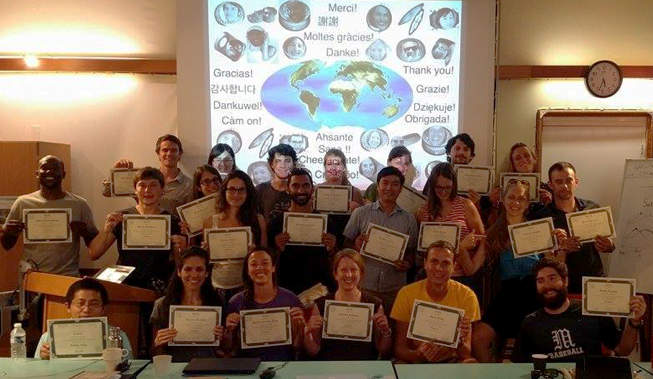
IOCCG Summer Lecture Series 2016 Students receiving their certificates
The third installment of the popular IOCCG Summer Lecture Series took place in Villefranche-sur-Mer from 18-20 July 2016, with generous sponsorship from the LOV Lab as well as EUMETSAT, the Ocean Carbon & Biogeochemistry (OCB) Program, the Scientific Committee on Oceanic Research (SCOR), and local organisations CNRS/INSU, OOV and GIS-COOC, which are all gratefully acknowledged. A total of 22 students from 15 different countries were selected from more than 140 excellent applications. Remote sensing specialists from various fields of ocean colour delivered a wide range of lectures and practical sessions, as well as open group discussions to facilitate interaction between the students and lecturers. Judging by the feedback from the students, the training course was a great success (see http://www.ioccg.org/training/Report-SLS-2016-final.pdf for full course report).
All the lectures were video recorded and are now available on the IOCCG website, along with all the PowerPoint presentations (see http://ioccg.org/what-we-do/training-and-education/ioccg-summer-lecture-series-2016/#lectures ).
This material provides a useful resource for the many deserving students who could not be accommodated due to space limitations, as well as researchers from around the world.
Call for IOCS-2017 Breakout Workshops
The 2017 International Ocean Colour Science meeting![]() (IOCS -2017) will take place from 15 to 18 May 2017 in Lisbon, Portugal, convened by the IOCCG in partnership with, and thanks to sponsorship from, EUMETSAT, ESA, NASA and the European Commission.
(IOCS -2017) will take place from 15 to 18 May 2017 in Lisbon, Portugal, convened by the IOCCG in partnership with, and thanks to sponsorship from, EUMETSAT, ESA, NASA and the European Commission.
We now invite proposals for parallel breakout workshops that will address current critical issues in ocean colour science, and provide feedback to the space agencies (deadline 30 November, 2016). Sessions will be scheduled to minimize topic overlap in the case of parallel sessions.
Each proposal requires a short abstract plus a list of at least three key questions to be addressed. The anticipated outcome and the relevance to the space agencies should be defined. The breakout sessions should take the form of workshops and should include a short introduction with up to three key talks, followed by group discussions centered on the key questions. It is important that the breakout workshops are not completely filled with oral presentations. Rather, a significant amount of time should be set aside for group discussions, as well as a synthesis of feedback that arises from these discussions.
For further information on submitting a proposal, as well as responsibilities of the breakout workshop Chairs, see the IOCS website at: http://iocs.ioccg.org/program/breakout-workshops/ .
New IOCCG Website
Over the past year, we have been working hard  to design and implement a new and improved IOCCG website (ioccg.org), which we hope is informative and easy to navigate. The new website has a consistent look and feel and is also mobile friendly! We have copied all of the content from the old IOCCG website, as well as updated the information. You will notice that the layout and navigation have changed so you may need to update your bookmarks accordingly. Please contact the IOCCG Project Office (vstuart@ioccg.org) should you find any broken hyperlinks or outdated material. Note that we are still putting some finishing touches to the new website.
IOCCG Executive Meeting
The 28th IOCCG Executive Committee Meeting took place on 24-25 October 2016 in Victoria, Canada, in conjunction with the Ocean Optics meeting. The members addressed many important issues that had emerged since the last IOCCG Committee meeting in March 2016, including proposals for new IOCCG working groups, implementation of the International Network for Sensor Inter-comparison and Uncertainty assessment for Ocean Color Radiometry (INSITU-OCR), and plans for the upcoming International Ocean Colour Science meeting (IOCS-2017). Discussions centered around the schedule for the meeting, composition of the Scientific Planning Committee, and selection of potential keynote speakers for the plenary sessions. All in all it was a very productive and collegial meeting.
News from NOAA: Lake Erie AERONET-OC
Lake Erie is now home to an environmental monitoring optical instrument 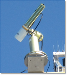 called a SeaPRISM and is the first Great Lakes site (and, in fact, the first site in all US inland waters) in the Aerosol Robotic Network – Ocean Color (AERONET-OC) program. This summer 2016, a team that included collaborators from University of New Hampshire (UNH); NOAA Office of Oceanic and Atmospheric Research (OAR) Great Lakes Environmental Research Laboratory (GLERL); NOAA National Environmental Satellite, Data and Information Service Office (NESDIS) Center for Satellite Applications and Research (STAR); NASA Goddard Space Flight Center’s AERONET program and from the Joint Research Centre of the European Union worked together to establish an AERONET-OC site in the western end of Lake Erie (Fig. 1) at a US Coast Guard Light #2 fixed tower (Fig. 2). The SeaPRISM instrument makes optical observations of the water surface and the atmosphere. These observations are used for validating satellite Earth observations among other uses. There are now 23 AERONET-OC sites globally. The Lake Erie site became the second AERONET-OC site in the world to be established in inland waters and is the fourth site supported by the NOAA. The other three NOAA-supported sites are in coastal waters around the US including Long Island Sound, Gulf of Mexico and the coast of California near Catalina Island.
A 9-channel model SeaPRISM on temporary loan from the AERONET-OC program was deployed for the summer 2016 season and began collecting data mid-July 2016 (Figure 3). This loaner SeaPRISM included wavelengths matching the primary ocean color bands on the Visible Infrared Imagery Radiometer Suite (VIIRS) on the Suomi-NPP (S-NPP) satellite. Next summer, for the 2017 season, a newly developed 12-channel model will be deployed. This 12-channel model is specifically configured to be useful for lake waters, which tend to be optically different from seawater. The 12 wavelengths align with VIIRS wavelengths and also with the major wavelengths important for ocean color validation on the recently launched OLCI Sentinel-3A Copernicus mission. These observations should also be useful for validation of Landsat and Sentinal-2 MSI.
Project principal investigator Dr. Tim Moore of UNH writes, “It was a very active first month for the SeaPRISM – (25 out of 31 days had observations) – capturing the bloom initiation, some floating algae, and sampled several water masses as they drifted by. The satellite validation exercise showed very good agreement with NOAA Science Quality VIIRS data.” He also notes a few discrepancies that need further investigation and characterization. “All in all, a very successful … deployment.”
News from NASA
NASA Goddard to Build PACE Spacecraft
NASA’s PACE (Plankton, Aerosol, Cloud, ocean Ecosystem) mission is scheduled to launch in  2022/2023 and will expand upon the NASA Goddard legacy of measuring ocean colour from space. The PACE mission will deliver the most comprehensive global ocean colour measurements in NASA’s history, enabling scientists to study Earth’s ocean ecosystems and their relationship to atmospheric aerosols and clouds. Detailed information on phytoplankton distributions are critical for understanding ocean ecology, the cycling of carbon from air to sea and back, and how these processes are being affected by climate change. New measurements made by PACE will help resolve the role of plankton in the Earth system and how changes to plankton communities will affect fisheries, ocean ecosystem functions, climate feedbacks and human health.
Following a recent decision by the agency, NASA Goddard will build the PACE spacecraft that will house the mission’s science instruments, electronics, and communications systems. Goddard is also building PACE’s primary instrument, a hyper-spectral radiometer that will measure the colour of the ocean from the ultraviolet to shortwave infrared. NASA officials also recommended the PACE project proceed with a competitive procurement for a multi-angle polarimeter to monitor aerosols that absorb or reflect solar energy. For more information about PACE, visit: http://pace.gsfc.nasa.gov/
Online Giovanni Workshop
The 2016 Gregory G. Leptoukh 3rd Online Giovanni Workshop will take place on November 15-17, 2016. The theme of this year’s workshop is “Using Giovanni for Geoscience Education”. Registration for the workshop is available here. See also the full schedule for the workshop.
News from ESA
Registration deadline for ESA “Vicarious Infrastructure Workshop”
The registration deadline for the workshop on “Options for future European satellite OCR vicarious adjustment infrastructure for the Sentinel-3 OLCI and Sentinel-2 MSI series” is fast approaching (15 November 2016). See the overview of the workshop for more information as well as registration details.
Sentinel-3A Earth Colour Data Released
On 20 October 2016, the Copernicus Sentinel-3A satellite took another step towards being fully ‘operational’ as the first data from its Ocean and Land Colour Instrument (OLCI) were officially released to users worldwide. Following its launch in February 2016, the satellite and instruments have been thoroughly tested and fine-tuned – leading to this important milestone. The Sentinel-3 validation team have received sample products since May 2016, and provided feedback to ESA and Eumetsat to help ensure the data are of the highest quality. The operations of the Sentinel-3A satellite are carried out by Eumetsat, while the mission is managed jointly by ESA and Eumetsat. ESA is responsible for the land data products and Eumetsat for the marine products – all of which are made available for application through Copernicus services.
The OLCI instrument monitors the global oceans and inland waters, and provides critical near-real time information for numerous applications including phytoplankton concentration, water quality, harmful algal blooms, sediment transport in coastal areas, El Niño and La Niña events, and climate change. See ESA Announcement for full details.
ESA EO Visualisation Tool for Heritage Missions
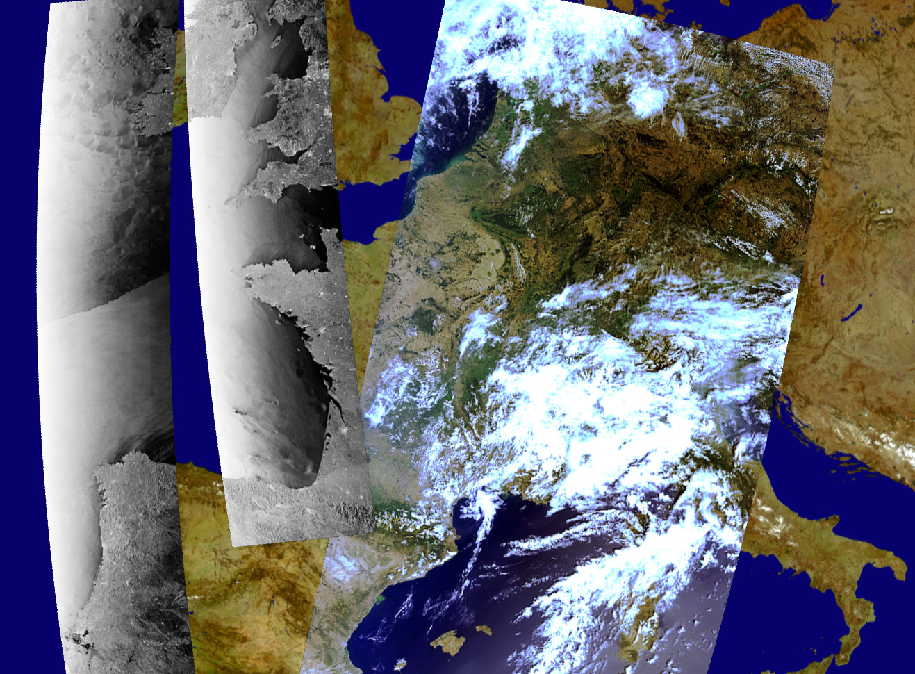
HEDAVI display with Envisat ASAR (right) and MERIS (left) images over Europe – ESA (2016)
The new ESA HEDAVI (HEritage DAta Visualisation) service enables users to discover a wealth of heritage data from ESA’s ERS and Envisat missions (i.e., MERIS full resolution swath), as well as from Landsat-5 and Landsat-7. The datasets are rendered on the MERIS mosaic, as well as allowing interchanges with a selection of global base maps. The service offers two levels of image visualisation:
- a basic search tool, for simple selection and visualisation of EO images,
- an expert search tool, with more specific image selection and with several image rendering options.
The images can be exported in GeoTIFF or KML/KMZ format or shared via Twitter. Further information on functionalities and handling of the tool is provided in the quick start video. Please visit ESA News for full announcement.
JAXA Research Announcement on Earth Observation
The Japan Aerospace Exploration Agency (JAXA) has issued the “1st Research![]() Announcement (RA) on the Earth Observation” for research activities during a two year research period starting from the Japanese Fiscal Year (JFY) 2017. In this 1st Research Announcement, JAXA solicits following research:
Announcement (RA) on the Earth Observation” for research activities during a two year research period starting from the Japanese Fiscal Year (JFY) 2017. In this 1st Research Announcement, JAXA solicits following research:
1) GCOM-W product development (algorithm and cal/val)
2) Application research for JAXA missions (GCOM-W, GCOM-C, TRMM/GPM, ALOS-2), or target-oriented research (Ocean Environmental Monitoring, Water Cycle/Water Resource Management, Atmospheric Environmental Monitoring, Infrastructure Displacement, Climate System/Radiation Process, Ecosystems (land), Agriculture, and Public Health).
Please note that PIs who were already adopted in the GCOM 6th RA do not need to apply to this RA again. RA details and forms for proposals can be downloaded from the following link: http://www.eorc.jaxa.jp/en/research/ra/1st_ra_eo/index.html . The deadline for proposal submission is 15 November 2016.
Jerlov Award
Prof. Curtis Mobley received the prestigious  Jerlov Award at the recent Ocean Optics meeting in Victoria, BC, Canada (23-28 October 2016), in recognition of his expertise in applications of radiative transfer theory to problems in optical oceanography and ocean colour remote sensing. He received his Ph.D. in Meteorology from the University of Maryland in 1977, and has been Vice President for Science and Senior Scientist at Sequoia Scientific, Inc. since 1996.
Dr. Mobley’s current research focusses on improving ocean ecosystem models by improving their light calculations (the light both heats the water and drives photosynthesis). Some of the best-known products of his past efforts include the widely-used HydroLight computer program, the textbook “Light and Water: Radiative Transfer in Natural Waters”, and the Ocean Optics Web Book. Dr. Mobley also enjoys teaching, and has taught many intensive courses and summer classes, including teaching at all three IOCCG Summer Lecture Series. On behalf of the IOCCG Committee we congratulate Dr. Mobley for his lifetime of achievements and contributions to optical oceanography and ocean colour remote sensing.
New Publications
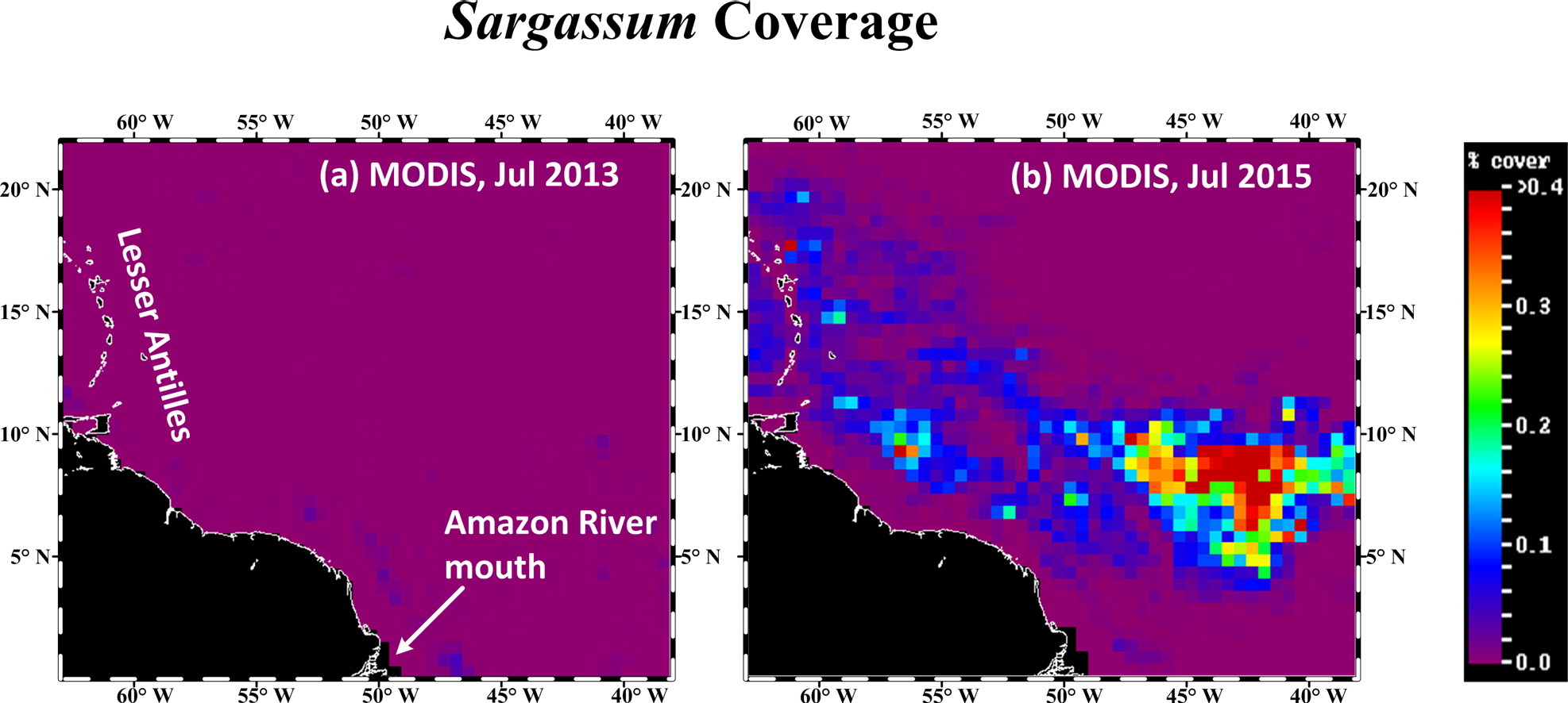
Several new publications have been added to the IOCCG Recent References list including a paper by Wang and Hu (2016) on mapping and quantifying Sargassum distribution. Sargassum washing ashore on the beaches of the Caribbean Islands since 2011 has caused problems for the local environments, tourism, and economies, yet little is known about their origin, distribution, and long-term changes. Following earlier works by Gower and coworkers, Wang and Hu (2016) developed an objective method to map Sargassum abundance from MODIS Alternative Floating Algae Index (AFAI) imagery between 2000 and 2015 in the central West Atlantic. They found that the summer months of 2015 showed mean coverage of > 2000 km2 after accounting for sub-pixel coverage (lower bound ~0.2% pixel size). This is about 4 times of the summer 2011 coverage when massive Sargassum beaching was first reported, and about 20 times of the summer 2000 to 2010 coverage. While understanding the causes of these inter-annual changes still requires further research, the MODIS AFAI imagery have been combined with surface ocean currents to form a prototype Sargassum Watch System (SaWS, Hu et al., 2016) to monitor Sargassum distributions, with daily updates in near real-time.

References:
Wang, M., and C. Hu (2016). Mapping and quantifying Sargassum distribution and coverage in the Central West Atlantic using MODIS observations. Remote Sens. Environ., 183:356-367. http://dx.doi.org/10.1016/j.rse.2016.04.019
Hu, C., B. Murch, B. B. Barnes, M. Wang, J-P., Marechal, J. Franks, D. Johnson, B. Lapointe, D. S. Goodwin, J. M. Schell, and A. N. S. Siuda. (2016). Sargassum watch warns of incoming seaweed, Eos, 97, doi:10.1029/2016EO058355. September 2, 2016. (https://eos.org/features/sargassum-watch-warns-of-incoming-seaweed)
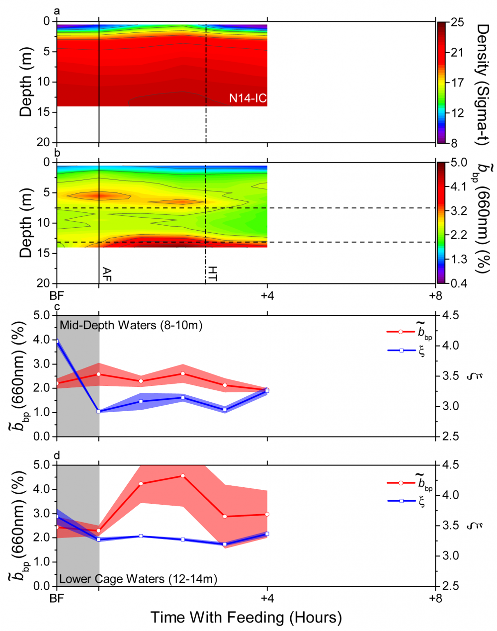
In another recent study, Del Bel Belluz et al. (2016) investigated variability of the particulate beam attenuation, scattering, and backscattering coefficients, along with discrete measurements of HPLC derived pigments and particulate organic carbon within and beside a finfish aquaculture cage on the west coast of Vancouver Island, Canada. Large bio-optical variability was observed over three seasons: fall, spring, and summer. Specifically, in fall, ambient particulate concentrations were low and lower-cage after feeding optical proxies suggest the dominance of large particles with high indices of refraction, possibly due to the influence of fish fecal particles. In turn, optical variability in spring and summer was driven by phytoplankton bloom conditions. Neither showed distinct optical signatures indicative of aquaculture wastes, possibly due to a masking effect. This effect has also been observed by other authors utilizing discrete sampling methods. Thus, optical characterization of organic waste dispersal is likely constrained to low ambient seston conditions. Outside of these conditions, bio-optical analysis would be beneficial for environmental monitoring of ambient particles moving through aquaculture systems.
References:
Del Bel Belluz, J., Costa., M., Reid, G., Cross, S. (2016). Bio-optical variability at a Vancouver Island aquaculture site. Limnology and Oceanography. 61, 1686-1704, doi: 10.1002/lno.10332. [Full article]

Fall (14 Nov 2011) time series map of a) density (sigma-t) and b)  (660nm) (%). Times are normalized to feeding, starting before feeding (BF), followed by after feeding (AF) and then 1 h intervals. Vertical solid line =AF times, dashed-dotted vertical line = high tide (HT). Horizontal lines represent 9 m and 13 m depths of the averaged time series data presented in c) and d), respectively. Data were averaged from 8 – 10 m and 12 – 14 m, with one standard deviation shown as shaded colours. Grey shading represents feeding duration (see article for full details).
Employment Opportunities
Several new employment positions have been posted on the IOCCG website including a Professor of Spatial Water Quality and Aquatic Systems at the University of Twente (Netherlands), a fixed-term contract with CyanoLakes (Pty) Ltd (South Africa), a Postdoctoral Fellow in Aquatic Remote Sensing (University of Maryland, USA), and a Senior (or tenure track) position in Marine Optics & Remote Sensing (Royal NIOZ-Texel, Netherlands). For further details on these, and other employment opportunities, see the Employment Opportunities page on the new IOCCG website at: http://ioccg.org/resources/employment-opportunities/
