This IOCCG news bulletin contains a summary of the latest news from the IOCCG, its sponsoring agencies, and the broader ocean colour community. If you would like to include an item of interest in the next IOCCG news bulletin, please contact the IOCCG Scientific Officer, Dr. Raisha Lovindeer (raisha@ioccg.org), with a cc: to Dr. Venetia Stuart (vstuart@ioccg.org). If you are having trouble receiving emails from IOCCG on your network, please see instructions on how to Whitelist “Campaign Monitor” (the IOCCG email marketing platform). Please also add raisha@ioccg.org, vstuart@ioccg.org and ioccg@ioccg.org to your list of contacts (especially important for subscribers with Gmail accounts – also check your SPAM folder).
IOCCG News
IOCCG Celebrates 25 Years of Existence
![]() The IOCCG celebrates 25 years in 2021! Committee members and sponsoring agencies submitted tributes to the Group. A few tributes have been shared below that encompass many of the sentiments expressed by all, and highlight major contributions of the IOCCG over the past 25 years.
The IOCCG celebrates 25 years in 2021! Committee members and sponsoring agencies submitted tributes to the Group. A few tributes have been shared below that encompass many of the sentiments expressed by all, and highlight major contributions of the IOCCG over the past 25 years.
“The IOCCG, through its tireless endeavours, outstanding publications, user engagement workshops and symposia, has spearheaded the transition of ocean colour science to the modern era of operational ocean colour radiometry from space. The biogeochemical measurements that are available from space today serve a myriad of societal applications from local to global climate scales. They are testament to the vision, tenacity and dedication of the IOCCG and its membership.
IOCCG from its very beginning made a major contribution to the Medium Resolution Imaging Spectrometer MERIS on ESA’s scientific ‘Flagship’ Earth Observation Mission Envisat, specifically with respect to the development of its water constituent data products and its calibration and validation procedures. Building upon these achievements, the Ocean and Land Colour Imager (OLCI) onboard the operational Copernicus Sentinel-3 mission benefitted from IOCCG’s work, its recommendations and its outstanding publications. Unforgotten shall be the excellent support to these missions from IOCCG colleagues, who are unfortunately no longer with us, Andre Morel, Trevor Platt, Roland Doerffer, Andreas Neumann, and Oleg Kopelevich.
The European Space Agency congratulates the IOCCG on 25 years of excellence and looks forward to an exciting future of hyper spectral measurements – set to reveal even more of the wonderful, yet fundamental, majesty of our oceans.”
– Craig Donlon & Mike Rast, ESA
“Through the generation of IOCCG reports, the ocean colour experts and the wider community have been able to be kept up to date with the latest knowledge and science. The importance of these reports is not only in their avid readership but also in the continued interest in being co-authors.”
– Samantha Lavender, Pixalytics Ltd, UK
“Speaking on the role that IOCCG has played in the ocean colour community, the IOCCG training courses have served as a means to not only educate people, but bring together cohorts of students that become lifetime collaborators, working together and contributing new science and applications.
Without the IOCCG, our community would be more fragmented and nationalistic. The ability to work together internationally on reports, meetings, and training courses has created cohesion and a sense of shared purpose.”
– Heidi Dierssen, Univ. Connecticut, USA
“IOCCG played an enormous role in the development of science related to ocean colour in Latin-America. Facilitating the interaction of representatives of space agencies from different countries, producing and making widely available the extremely useful reports on different aspects of ocean colour, and providing state of the art training for hundreds of students in the region. This capacity-building went far beyond the contents during the courses — it provided venues for interactions leading to the enhancement of the careers of many professionals. The Antares network of the Latin-American time series was fostered by such interactions provided by IOCCG. We look forward to many more years of productive work together.”
– Vivian Lutz & Ana Dogliotti, Argentina
The top 10 accomplishments of the IOCCG over 25 years were collated by the committee and posted to our twitter page @IOCCG (follow us!) on World Oceans Day under the hashtags #IOCCG25 #Top10. Feel free to post your own tributes using the #IOCCG25 hashtag (and tag us!) throughout 2021.
IOCCG-25 Committee Meeting
Due to the COVID-19 pandemic, the 25th annual IOCCG Committee meeting was completely virtual, held over four days from May 4 – 13, 2021. The meeting was attended by 37 representatives from various space agencies and research institutions, internationally. The Committee received updates and plans for future ocean colour activities from agencies in Argentina, Canada, China, Europe, India, Italy, Japan, and USA, as well as from IOCCG working groups and task forces. Additional topics discussed included upcoming events and initiatives—such as the Ocean Carbon from Space workshop, and ESA’s Essential Climate Variable (ECV) for lake colour under their Climate Change Initiative (CCI)—as well as the future of IOCCG for the next 25 years. No rotation of Committee Members took place this year, to maintain stability during the pandemic. The final minutes of the meeting are available here.
HAB Working Group Completed
The working group on Harmful Algal Blooms and Ocean Colour, chaired by Stewart Bernard, gave their final meeting update. The working group is now completed, and IOCCG Report 20 on Observation of Harmful Algal Blooms with Ocean Colour Radiometry is now available here on the IOCCG website.
News from NASA
NASA Community Processor for In Situ Radiometry Released
![]() The Hyperspectral In situ Support for PACE (HyperInSPACE) software package was released in March for public distribution. The package is designed to facilitate processing of ocean color radiometry from automated sensors mounted on ships or towers for the purpose of satellite data validation and ocean color algorithm development.
The Hyperspectral In situ Support for PACE (HyperInSPACE) software package was released in March for public distribution. The package is designed to facilitate processing of ocean color radiometry from automated sensors mounted on ships or towers for the purpose of satellite data validation and ocean color algorithm development.
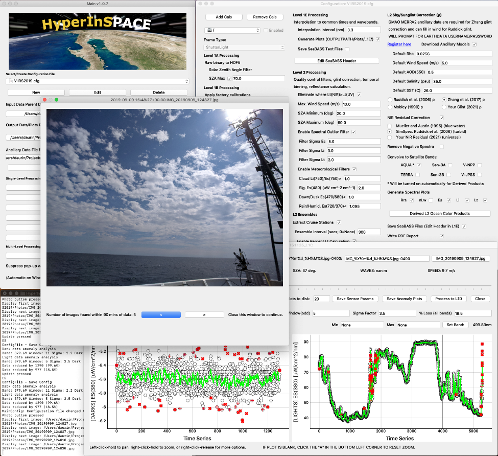
The HyperInSPACE user interface showing various elements of the data processing configuration and data visualizations.
Radiometry from autonomous platforms is especially beneficial in retrieving ocean color and related products over large temporal and spatial scales. It provides high data density for algorithm development as well as more opportunities for good quality, cloud-free matchups with satellite overpasses. HyperInSPACE was developed by NASA’s Ocean Ecology Laboratory to provide a means of applying rigorous quality controls to autonomous radiometry as well as highly customizable methods for key processing elements, such as sun/skylight glint removal, in accordance with the latest IOCCG protocols and state-of-the-art methods in the literature. It includes options for fully hyperspectral glint correction with polarization terms; calculates uncertainties in primary and secondary products; produces a detailed report with data visualizations; retains processing parameters for later reference; and can convolve hyperspectral output to various satellite sensor wavebands.
The software was designed as an open-source package in Python to provide a fully transparent and adaptable interface for users. This will simplify community collaboration for incorporating new instrument platforms, new quality control filters, new glint and residual reflectance correction methodologies, new ocean color products, and more. The software includes a simple graphical user interface with interactive data visualizations to help in choosing the best processing configuration for each data file. Level-2 processed radiometry can be output in various formats including files ready for submission to NASA’s SeaWiFS Bio-optical Archive and Storage System (SeaBASS). The complete repository and detailed guide are available for download on the NASA GitHub site: https://github.com/nasa/HyperInSPACE/.
NASA’s Upcoming Geostationary Ocean Colour Mission (GLIMR)
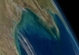
Enhanced true color image of the northern Gulf of Mexico. Source: NASA.
NASA issued a contract on 17 May 2021 to the University of New Hampshire (UNH) to manage the instrument build and scientific investigation for the Geostationary Littoral Imaging and Monitoring Radiometer (GLIMR). GLIMR is a hyperspectral ocean color sensor launching after 2026 that will target the Gulf of Mexico and other coastal and ocean waters of North and South America. With its vantage point from geostationary orbit, GLIMR will be the first hyperspectral ocean color sensor to study ocean processes at the diurnal timescales required to observe the dynamic ecological, biogeochemical and physical processes typical of coastal and ocean waters. GLIMR is uniquely designed to capture the spatio-temporal evolution of phytoplankton blooms (time scales of hours to days); monitor phytoplankton physiology, growth rates and shifts in community composition; resolve coastal features, fronts, eddies and upwelling features; and monitor biogeochemical fluxes and land-ocean exchanges at sub-diurnal to multi-day scales. GLIMR will improve quantification of primary productivity, biomass, and carbon fluxes within coastal aquatic ecosystems and across the land-sea interface. It will contribute observations that will aid development and evaluation of models that project future changes in carbon cycling and marine ecosystems for use in ecological forecasting and as inputs for improved climate change predictions. The two main science goals of GLIMR are (1) to understand the processes contributing to rapid changes in phytoplankton growth rate and community composition, and (2) quantify how high frequency fluxes of sediments, organic matter, and other materials between and within coastal ecosystems regulate the productivity and health of coastal ecosystems. The science applications objectives aim to study the formation, magnitude, and trajectories of harmful algal blooms (HABs), oil spills, and Sargassum accumulation events.
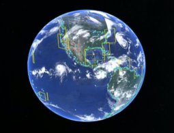
Proposed science field-of-view for GLIMR with ocean color scenes denoted as yellow rectangles. Cyan disks show location of landmarks for GLIMR image navigation and registration.
At the heart of the GLIMR instrument is a spectrometer with a nadir spatial resolution of 300 m, spectral range between 340-1040nm, a spectral resolution of about 10 nm, and capability to scan the Gulf of Mexico in about 70 minutes at an SNR performance of >1000 in the near-UV and visible and >600 in the NIR. A higher spatial resolution and mark imager co-aligned with the spectrometer enables image navigation and registration of the ocean color pixels collected by the spectrometer.
GLIMR’s science and applications objectives align closely with the science goals laid out in the 2018 National Research Council Earth Science and Applications from Space Decadal Survey. GLIMR provides US federal, state, and local agencies with vital information on coastal hazards (oil spills, HABs, post-storm assessment, water quality) for improved response, containment, and public advisories both at sea and along the coast. It is configurable to respond to episodic events and hazards.
NASA selected the GLIMR proposal on 1 August 2019 under the Earth Venture Instrument-5 opportunity. GLIMR is led by UNH Principal Investigator Joseph Salisbury. The GLIMR team includes Raytheon Intelligence & Space, which will build the instrument, Goddard Space Flight Center, which will support the PI in leading the scientific investigation and manage the ocean color data processing and distribution, Southwest Research Institute, which will manage the safety and mission assurance aspects, and a science team of co-investigators and collaborators from U.S. universities and federal agencies and various institutions in Europe, Australia, and South Korea, who will provide data product algorithms, scientific analysis, and enable applications. The program office at NASA Langley will manage the host accommodations, launch, and oversight of the GLIMR mission for NASA.
HawkEye Ocean Colour Instrument on SeaHawk Cubesat in Operation
NASA along with their collaborators at the University of North Carolina, Wilmington, Cloudland Instruments, AAC-Clyde Space, and the Moore Foundation, announced that the SeaHawk Cubesat with the HawkEye ocean color instrument entered routine operations phase on Monday, 21 June 2021 after over two years of intensive commissioning efforts.
Calibration configuration used in the production system and provided in the new version of SeaDAS that fully supports HawkEye data is optimized for data collected after 16 April 2021. NASA recently announced that the international research community now has the opportunity to request specific targets or regions of interest to be acquired by the HawkEye Instrument. As part of their goal of demonstrating the capabilities of this mission to its fullest extent, the team at the University of North Carolina, Wilmington (UNCW) and Skidaway Institute of Oceanography at the University of Georgia, have created a portal by which the research community can submit requests for imagery acquisition. To find out more details about how to do this and to request imagery of your region of interest, please follow this link.
Read full details, including links about the mission, its history, data products, operations and data access at https://oceancolor.gsfc.nasa.gov/data/hawkeye/. Since going operational on 21 June 2021, they have collected over 350 new images which brings to more than 1,000, the number of images that they have collected and downlinked. All processed images are available at Level-1 and Level-2 for download on the Ocean Color Web Browser.
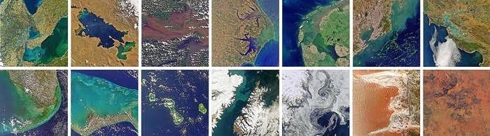
Example images acquired by HawkEye between December 2019 and June 2021
NASA-funded EXPORTS North Atlantic Field Campaign Concluded
On June 1st, the RRS James Cook and the RRS Discovery sailed into port in Southampton, marking the end of the NASA funded EXPORTS field campaign to the North Atlantic Ocean. Together with the Woods Hole Oceanographic Institution’s Ocean Twilight Zone project-funded R/V Sarmiento de Gamboa and a fleet of over 45 autonomous platforms, these research vessels were part of the month-long field experiment targeting the export and fate of upper ocean net primary production created by the North Atlantic spring bloom.
The final goal of EXPORTS is to enable the use of remote sensing and measured parameters to develop better ways—through new ocean color algorithms and models—to observe and understand the biological carbon pump in the ocean today and in the future. For those reasons, EXPORTS relies on numerous optical measurements to make a connection between the measured processes and remote sensing observation. This elaborate optical and biogeochemical dataset will be crucial for development of new algorithms for NASA’s upcoming Plankton, Aerosol, Clouds, ocean Ecosystem (PACE) mission.
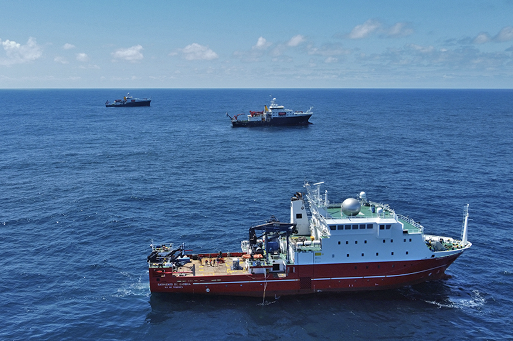
R/V Sarmiento (front), RRS Discovery (center) and RRS James Cook (back) during the EXPORTS N. Atlantic Field Campaign… and the weather was this beautiful throughout! Credit: WHOI
The investigation took place near the PAP Observatory, in a retentive anticyclonic eddy, making the time observations in its center nearly Lagrangian, and offered an opposite end member to the experiment conducted in the North Pacific in 2018. A Lagrangian float positioned at the base of the euphotic zone defined the center of the eddy and gave a frame of reference. The float was closely followed by the process ship (RRS James Cook) from which a large suite of experiments, measurements, and over the side deployments were conducted that focused on gaining an understanding of the interactions between food web processes and ocean biogeochemistry. Two NASA Seagliders, one NOC Slocum glider, 2 BGC floats, and the survey ship (RRS Discovery) collected oceanographic information from the waters within and surrounding the eddy. While the majority of the story will be unraveled over the next year as the science teams analyze their data, an early view (thanks to the army of autonomous vehicles and remote sensing tools) suggests that the experiment was a success! The EXPORTS team found and tracked a retentive eddy throughout its 27 days on site. The spring bloom, dominated by large diatoms, eventually collapsed and a transition to export flux was observed.
The NASA EXPORTS Project is extremely thankful to their partners and collaborators, especially the scientists, WHOI’s Ocean Twilight Zone, and the captains, crew, and marine technicians of the UK’s National Oceanographic Centre in Southampton. Funding provided by NASA and additional support from NSF allowed this large interdisciplinary team to overcome the challenges of the COVID pandemic and successfully complete a comprehensive field campaign, which has produced data that will support scientific research on oceanic carbon cycle and remote sensing for decades to come.
News from NOAA
Dedicated JPSS VIIRS Ocean Color Cal/Val Cruises
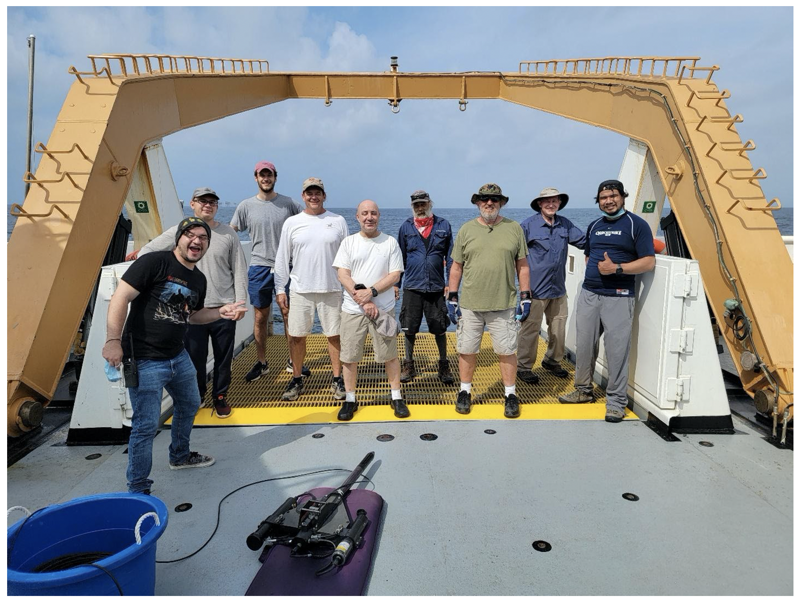
Figure 1. GU-21-01Cruise Participants. From left to right: Roberto Arias, Mateusz Malinowski, Clemente Borgogni, Eric Stengel, Nick Tufillaro, Charles Kovach, Michael Ondrusek, David English and Eder Herrera. Photo credit: NOAA
The 6th dedicated JPSS VIIRS Ocean Color Cal/Val cruise was successfully completed. The NOAA Ocean Color Team, along with collaborators from the University of Boston, the University South Florida, Oregon State University, the City College of New York, Lamont Doherty Earth Observatory at Columbia University, the University of Puerto Rico, the Naval Research Laboratory, and the National Aeronautics and Space Administration, conducted the sixth annual NOAA Ocean Color Cal/Val cruise. The contingent of cruise participants was slim this year due to the pandemic-related travel restrictions (Figure 1). The crew included two NOAA Experiential Research and Training Opportunities (NERTO) interns, Roberto Arias from University of Puerto Rico and Eder Herrera from City University of New York. After quarantining in Biloxi, MS for seven days in accordance with Office of Marine and Aviation Operations (OMAO) COVID-19 safety protocols, the team departed Pascagoula, MS aboard the NOAA Ship Gordon Gunter on April 20th and returned April 29th.
Simultaneous measurements of water-leaving radiance by each of the Cal/Val team members provide a direct validation assessment of the satellite performance. At each station, team members brought their expertise in measuring most of the derived ocean color products including phytoplankton pigment, absorption and scattering coefficients, attenuation coefficients, phytoplankton functional types, colored dissolved organic matter and many others. This simultaneous measurement of water-leaving radiances and products of interest allow the validation and refinement of existing ocean color algorithms and the development of new ones.

Figure 2. GU-21-01 Cruise Track and station markers overlaid on a sensor (SNPP, NOAA-20, Sentinel 3A/B) merged chlorophyll weekly mean composite covering the entire project. The project took place from April 20th (Sta. 1) to April 29th (Sta. 33). Imagery Courtesy of Sherwin Ladner, NRL.
Thirty-three stations were visited on this cruise (Figure 2), and 26 of those stations were also able to be paired (clear-sky matchup) with 26 SNPP overpasses and 21 NOAA20 overpasses. In addition, validation measurements were conducted for several days at WavCIS AERONET-OC sensor (Sta. 5, 6, 7, 8, 17, 18, 19). Over 8 inches of rain prior to the cruise contributed to the load of particulate and dissolved solids in the nearshore area. The cruise science team was able to sample a wide range of marine optical conditions from river plumes extending into extremely blue water. These observations will lead to better optical characterization of coastal water inundated with fresh water intrusion in contrast to offshore waters for use in routine ocean color environmental monitoring.
Previous NESDIS Technical Reports on the Dedicated JPSS VIIRS Ocean Color Calibration/Validation Cruise Series:
- Report #154 September 2019 doi: 10.25923/p9de-yw97
- Report #152 May 2019 doi: 10.25923/scyb-qf42
- Report #151 October 2016 doi: 10.7289/V5/TR-NESDIS-151
- Report #148 December 2015 doi: 10.7289/V5/TR-NESDIS-148
- Report #146 November 2014 doi: 10.7289/V52B8W0Z
NOAA Ocean Color Coordinating Group (NOCCG)
The NOAA Ocean Color Coordinating Group (NOCCG) hosted a seminar by IOCCG’s own Dr. Raisha Lovindeer. Dr. Lovindeer spoke on a topic from her dissertation, “Spectral characterization & cyanobacteria abundance by remote sensing reflectance in the Indian River Lagoon“. After her well-received presentation, a discussion followed about how satellite observations could be applicable to this work. The NOCCG, so-named in honor of and inspiration by the IOCCG, was formed by Paul DiGiacomo in 2011 to bring together people from across all parts of NOAA with interests in ocean color. Dr. Cara Wilson, current chair of IOCCG, had served as chair of the NOCCG for several years. The group convenes bi-weekly and hosts a seminar about once a month. Seminars are advertised widely throughout NOAA and to the general public. Sign up to receive notifications of all NOAA seminars.
Recent Peer Reviewed Publications from the NOAA Ocean Color Science Team
Liu, X. and M. Wang, “Deriving VIIRS high-spatial resolution water property data over coastal and inland waters using deep convolutional neural network”, Remote Sens., 13, 1944 (2021). doi:10.3390/rs13101944
News from EUMETSAT and NOAA
Second International Operational Satellite Oceanography Symposium
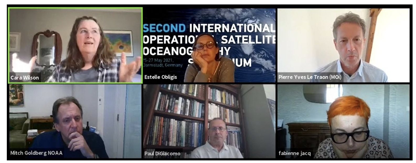
OSOS2 Space Agency Panel: Top left, Cara Wilson NOAA NMFS (panel moderator); Top center, Estelle Obligis – EUMETSAT; Top right, Pierre Yves LeTraon – Mercator Ocean; Bottom left, Mitch Goldberg – NOAA NESDIS; Bottom center, Paul M. DiGiacomo – NOAA NESDIS STAR; Bottom right, Fabienne Jacq – European Commission. Photo Credit NOAA
The Second International Operational Satellite Oceanography Symposium (OSOS2) was held virtually May 25-27, 2021. OSOS2 was the culmination of a tremendous effort by the all-volunteer Programme Committee and staff at both agencies over the last two years. The Programme Committee was co-chaired by Dr. Estelle Obligis of EUMETSAT and Dr. Veronica Lance of NOAA.
EUMETSAT led the virtual symposium which was originally planned to take place in Darmstadt. NOAA the 1st OSOS in 2019 held in College Park, Maryland at the NOAA National Center for Weather and Climate Prediction. This year’s event garnered 479 registered attendees from 57 countries – with peak daily attendance at 338 online at one time. This dramatic increase was due in part to the virtual meeting overcoming travel barriers, but also because of esteem-building for the symposium arising in the Operational Satellite Oceanography community following the successful 2019 event.
The ambitious agenda tackled at OSOS2 grew directly out of recommendations for future actions collected during OSOS1, and with guidance and input from the distinguished 23-member OSOS2 Programme Committee. Some satellite remote sensing products are integral to operational applications for routine and event-driven environmental assessments, predictions, forecasts, and management. Yet ocean satellite data are still underutilized and have a huge potential for contributing further to societal needs and the blue economy. OSOS2 focused on the use of satellite data in coupled numerical models for ocean, weather, climate and environment analysis and prediction; and in operational applications for coastal waters. A combination of oral presentations, panels, and poster sessions informed attendees about the latest in Operational Satellite Oceanography science and issues. Over 70 poster presentations and over 30 talks were made available during nine interactive poster and oral sessions. A Symposium Report is planned. The third OSOS will be hosted by NOAA in 2023.
OSOS2 recordings, presentation slides, and posters remain available for viewing on the meeting website. Read more about the event, including a list of topics, themes, and outcomes here.
ISRO to Launch GISAT-1
 The Indian Space Research Organisation (ISRO) will soon launch the GISAT-1 satellite into geostationary orbit (planned for 12 Aug 2021). GISAT is the first of its kind and a unique geostationary imaging satellite for acquiring simultaneous and integrated observations of land, ocean and atmosphere at relatively high resolution using hyperspectral techniques It will provide near real time imaging for the Indian sub-continent and parts of eastern Asia (ideal for observing disasters and other episodic events). GISAT-1 will carry an imaging payload consisting of three sensors including a multispectral VIS-NIR imager and two hyperspectral instruments at with relatively high signal to noise ratios and a spatial resolution of 42 to 318 m. Furthermore, the high temporal resolution will provide near real time imaging with fast revisit and real time monitoring capability. The satellite will operate on an orbital slot around 93.5° East. Satellite ocean data will be used for multiple applications including fishery forecast, coastal zone management and carbon cycling.
Chinese HiSea-2 SmallSat Launched
On June 11, 2021, the HiSea-2 Water Color Satellite of Xiamen University, China, was successfully sent to orbit, with its first image beamed down on June 12, 2021. HiSea-2, jointly developed by DFH Satellite Co., Ltd and Xiamen University, is a smallsat weighted at 65 kg, with a specific focus on water-quality parameters in coastal and inland waters. It has eight bands centered at 450, 490, 570, 625, 680, 710, 745, and 865 nm, with a signal-to-noise ratio > 270. The spatial resolution is 20 m, with a swath ~180 km, thus HiSea-2 provides not only wide coverage, but also fine details of the aquatic environments (see sample images below). After on-orbit adjustment and calibration, HiSea-2 data will be open for the community for scientific studies. HiSea-2 is the second smallsat funded by Fujian Tendering Purchasing Group Co., Ltd. and Sanming Investment Development Group Co., Ltd. The team plans to launch 40+ more smallsats in the coming years to form the HiSea constellation aimed at the coastal and inland aquatic environments.
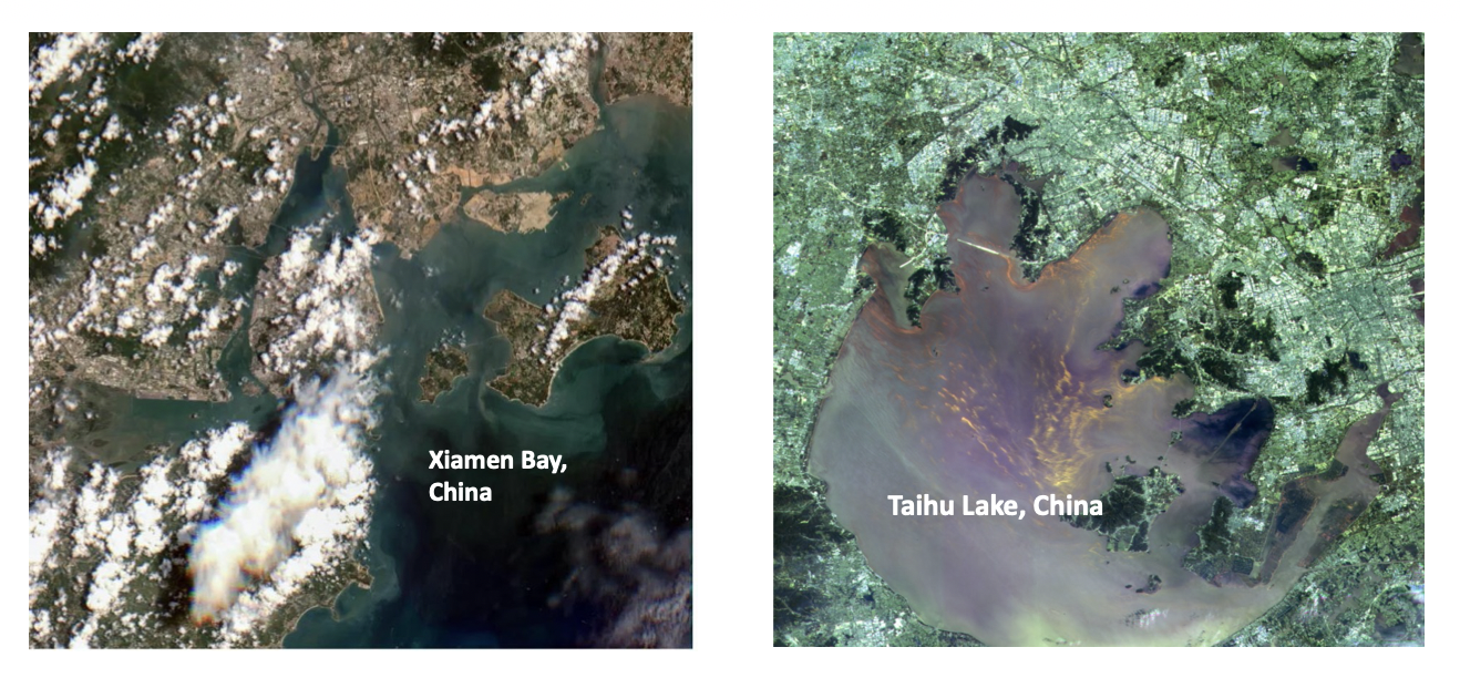
False color images compiled from HiSea-2 measurements (Xiamen University, China), where an intense bloom of cyanobacteria in Taihu Lake was well captured.
Journal Special Issues
Aquatic Carbon Stocks and Fluxes
 Contributions are invited for a special edition on Aquatic Carbon Stocks and Fluxes: The Big Picture from Remote Sensing to be published in Earth-Science Reviews. Our understanding of carbon cycling, biogeochemistry, ecology, and interactions of global aquatic systems with the atmosphere has greatly improved through observations using airborne and satellite remote sensing systems. While a rich scientific literature exists, we lack a compiled synthesis of developments, findings, and future directions that is accessible to researchers and the broader scientific community. This call is for contributions that synthesize our current understanding of carbon stocks and fluxes in aquatic systems, as well as directions for future advancements, with a particular focus on globally relevant topics that rely on the use of remote sensing data, including integration with in-situ measurements and models. The outcome of this effort will be a collection of invited and contributed papers that summarize the current state-of-the-science and establish a roadmap for future developments. Interested authors should submit a letter of intent (1-page max.) for a proposed review article to Chuanmin Hu (huc@usf.edu) and Laura Lorenzoni (laura.lorenzoni@nasa.gov) by August 1, 2021.
AI and Remote Sensing in Ocean Sciences
![]() Remote sensing data has provided synoptic information on the global ocean continuously for the past four decades. Its analysis is often done through very standard processing routines that, over the years, have been challenged by machine learning approaches. AI and deep learning methods have great potential to explore new data-driven and learning-based methodologies and propose computationally efficient strategies able to benefit from the large amount of observational remote sensing, to finally improve the quality of oceanographic research approaches. A Frontiers Research Topic call on AI and Remote Sensing in Ocean Sciences is designed to gather a large range of uses of AI and deep learning methods applied to remote sensing in any field of ocean sciences. Submission deadlines: 31 August 2021 for abstracts and 31 December 2021 for manuscripts.
Remote sensing data has provided synoptic information on the global ocean continuously for the past four decades. Its analysis is often done through very standard processing routines that, over the years, have been challenged by machine learning approaches. AI and deep learning methods have great potential to explore new data-driven and learning-based methodologies and propose computationally efficient strategies able to benefit from the large amount of observational remote sensing, to finally improve the quality of oceanographic research approaches. A Frontiers Research Topic call on AI and Remote Sensing in Ocean Sciences is designed to gather a large range of uses of AI and deep learning methods applied to remote sensing in any field of ocean sciences. Submission deadlines: 31 August 2021 for abstracts and 31 December 2021 for manuscripts.
Polarization of Light
![]() Polarized light emerging from the Earth system carries a plethora of information about both the atmosphere and the ocean that is underutilized, in particular in ocean remote sensing. Several new satellite missions are in development that will host advanced multi-angle polarimeters—including the NASA PACE mission (2023) and the ESA/EUMETSAT MetOp-SG program with six satellites to be launched from 2023 to 2037. There is also an increasing availability of in- and above-water instruments to measure the polarization state of seawater. A Frontiers Research Topic on Polarization of Light as a Tool for Characterizing Different Facets of the Atmosphere-Ocean System will showcase results that contribute to the assessment of the value of polarimetric measurements of light, in, just above, and over the ocean. Papers highlighting passive and active air- and space-borne, in situ, and radiative transfer analyses are all welcome.
Polarized light emerging from the Earth system carries a plethora of information about both the atmosphere and the ocean that is underutilized, in particular in ocean remote sensing. Several new satellite missions are in development that will host advanced multi-angle polarimeters—including the NASA PACE mission (2023) and the ESA/EUMETSAT MetOp-SG program with six satellites to be launched from 2023 to 2037. There is also an increasing availability of in- and above-water instruments to measure the polarization state of seawater. A Frontiers Research Topic on Polarization of Light as a Tool for Characterizing Different Facets of the Atmosphere-Ocean System will showcase results that contribute to the assessment of the value of polarimetric measurements of light, in, just above, and over the ocean. Papers highlighting passive and active air- and space-borne, in situ, and radiative transfer analyses are all welcome.
Events
NASA PACE Applications Workshop Registration Now Open
 NASA’s Plankton, Aerosol, Cloud, ocean Ecosystem (PACE) Mission invites you to their 2nd annual PACE Applications Workshop, which will be held virtually on September 15 & 16. This 2-day event will focus on future uses of PACE satellite data, products, and applications, to benefit society and support decision-making in the context of water resources, air quality and health, climate, disasters, and ecological forecasting. Register here!
Geospatial Applications for Disaster Risk Management MOOC Closing Soon
The United Nations Office for Outer Space Affairs and the Centre for Space Science and Technology Education for Asia and the Pacific (Affiliated to the United Nations) launched a free Massive Open Online Course (MOOC) on Geospatial Applications for Disaster Risk Management, that uses Earth observation technologies in application to disaster risk management. The course is now available and will be open until 31 August 2021. Read more about the course here. Register here! Registration closes on 15 August 2021.
OSM 2022: Ocean Technologies & Observatories call for Abstracts
 Call for abstracts for a hybrid session at the 2022 Ocean Sciences Meeting on Lidar Technology for the Estimation of the Surface and Vertical Ocean Physical, Optical, and Biogeochemical Properties. The session is chaired by Cédric Jamet and will be a hybrid session that will occur in Honolulu in Feb 2022, but with some form of interactivity with virtual participants.
The session aims at developing an oceanic Lidar community and at demonstrating the complementary between Lidar and standard ocean color observations. Read the full session description here. Abstract submissions will officially open later this summer and will close 15 September 2021.
Invitation to ESCAP’s eLearning Course on Marine Debris
 ESCAP’s Closing the Loop project has launched a new eLearning course: Cities and Marine Plastic Pollution: Building a Circular Economy. It’s packed with technical but accessible information about measuring, monitoring, and preventing marine plastic. Module 4 is particularly relevant, as it overviews ways to use remote sensing for plastic detection in rivers and coastal environments. Register here!
New Publications
Dierssen et al. (2021) have just published a new resource paper on hyperspectral remote sensing for aquatic applications. The authors provide tables with the latest reviews, databases, software, and outreach programs available for practitioners moving into the field of hyperspectral remote sensing. They highlight recent advances in sensor design, modes of deployment, and image analysis techniques for handling “big data” hyperspectral imagery. They also provide a unique framework for classifying algorithms from using spectra as descriptors, predictors, and references. Space and airborne platforms are discussed (see figure below), as well as future missions and advances in unoccupied aerial systems (UAS) and autonomous in-water survey methods. Analogous to transferring computing power from mainframes to personal computers in the 1980s, they discuss the shift in access and control of imaging system from external organizations and large satellites to the individual researcher. They highlight the need for standardized community best practices for data capture and quality control, and open and FAIR (findable, accessible, interoperable, and reusable) data. The field of hyperspectral aquatic remote sensing is on the cusp of providing novel ways and new parameters to sense aquatic ecosystems that can be better used by decision-makers and scientists alike.

Architecture of various international missions showing the tradeoff between number of spectral bands, revisit frequency (X and Y axes, respectively) and the spatial footprint (approximated as the size of circle). Gray represents multi-spectral missions and colors represent the hyperspectral missions. Modified from Hestir et al. (2015a).
Another resource paper on hyperspectral imaging was recently published by Qian (2021). The detailed spectral information acquired by hyperspectral imagers often yields results not possible with multispectral or other types of satellites. This paper provides an overview of spaceborne hyperspectral imagers, technology evolution, and development history. It includes the principle of hyperspectral imaging, as well as a review of the history of hyperspectral technology development at various space agencies around the world. Current spaceborne hyperspectral imagers are described, including mission objectives with the focus on instrument performance parameters and technical features. This paper also provides an overview of six upcoming spaceborne hyperspectral imagers: EnMAP, MAJIS, OCI, HyspIRI, FLORIS and CHIME.
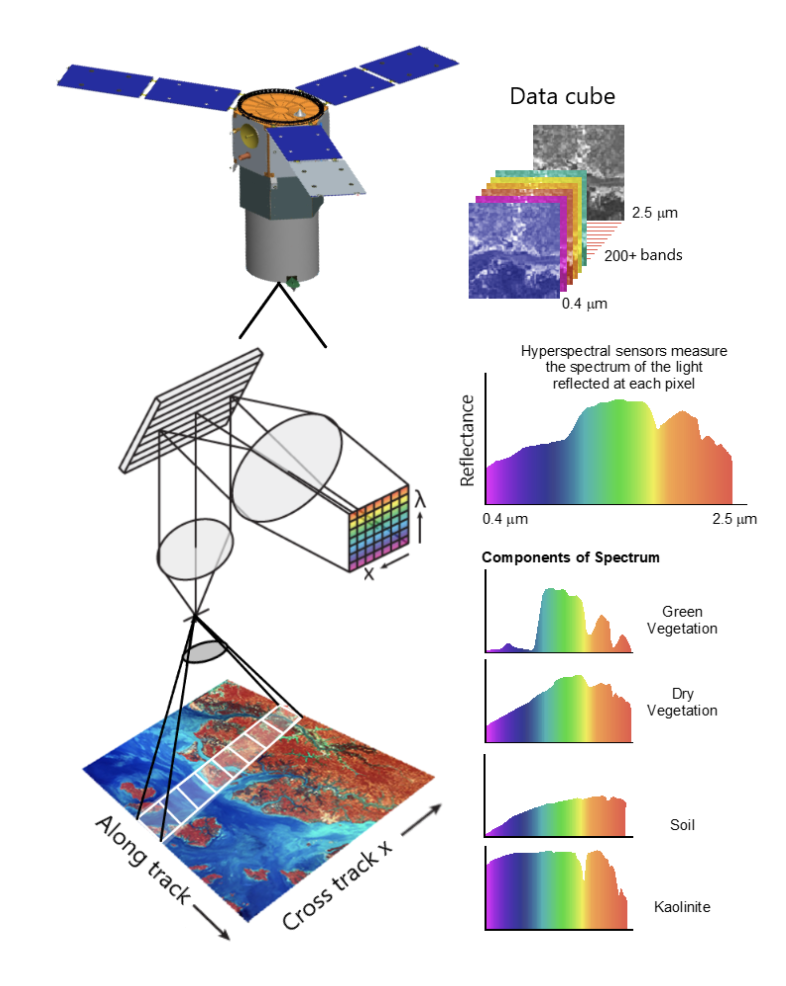
Illustration of concept and principle of a hyperspectral satellite. A data cube and a spectrum are generated by a hyperspectral satellite for each pixel.
A new publication by Lee et al. (2021) examines confidence measures of shallow-water bathymetry data. With the advancement of Lidar technology, bottom depth (H) of optically-shallow waters (OSW) can be measured accurately with an airborne or space-borne Lidar system (HLidar), but this data product consists of a line format rather than the desired bathymetry map, especially when the Lidar system is on a satellite. Meanwhile, radiometric measurements from multiband imagers can also be used to infer H (Himager) of OSW and obtain a map of bottom depth, but the accuracy varies. It is logical and advantageous to use the two data sources from collocated measurements to generate a more accurate bathymetry map of OSW, where usually image-specific empirical algorithms are developed and applied. After an overview of both empirical and semi-analytical algorithms for the estimation of H from multiband imagers, the authors emphasize that the uncertainty of Himager varies spatially, although it is straightforward to draw regressions between HLidar and radiometric data for the generation of Himager. Further, they present a prototype system to map the confidence of Himager pixel-wise, which has been lacking until today in the practices of passive remote sensing of bathymetry. They conclude by advocating for the generation of confidence measures in parallel with Himager, which is important and urgent for broad user communities.
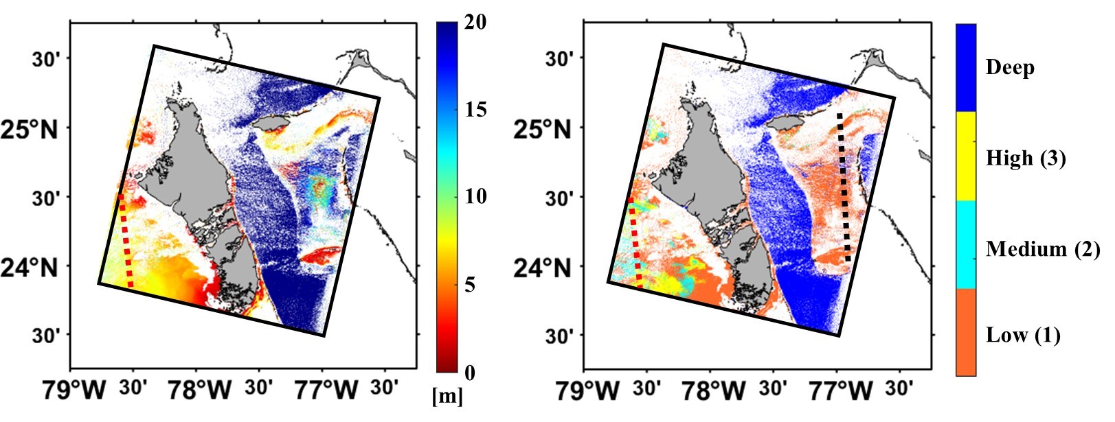
(left) Himager map obtained from Landsat-8 OLI Rrs after applying HOPELS8. (right) Confidence score map for the Himager product shown on the left. Grey colour for land, white for cloud or non-valid Rrs. The red and black dashed lines represent ICESat-2 tracks.
In another recent study, Wu et al. (2021) attempt to reconcile between optical and biological determinants of the euphotic zone. The conventional use of optically determined 1% of surface photosynthetically available radiation (PAR) depth (Z1%PAR, l = 400 to 700 nm) as a metric for the euphotic zone depth (Zeu) has been a matter of debate for several decades because of frequent inconsistencies with the base of euphotic zone determined biologically, i.e., the compensation depth (Zc). The authors use a large dataset of coincidental profiles of downwelling irradiance and primary production covering open ocean waters in the tropics, subtropics, and temperate regions, as well as from two time-series stations: the Hawaii Ocean Time-series (HOT) and the Bermuda Atlantic Time-series Study (BATS). They report that, at least for these measurements, Z1%PAR is too shallow (by 14.1%) compared to Zc, while Z0.1%PAR is too deep (by 32.7%). Further, the irradiance at Zc (i.e., the compensation irradiance, Ic) varies by a factor of more than five, but its ratio to surface irradiance is relatively stable. In general, Ic corresponds to 0.48 ± 0.23% of surface PAR, or 0.87 ± 0.40% of surface usable solar radiation (USR, for l = 400 to 560 nm), or 1.50 ± 0.67% of surface downwelling irradiance at 490 nm. These results suggest that Z0.5%PAR, or Z0.9%USR, or Z1.5%490 could be promising alternatives to bridge the optical and biological determinants of the euphotic zone depths for waters in the open ocean at low to middle latitudes. Since about 40% of surface PAR (in the range of 560 – 700 nm) do not penetrate much in aquatic environments, these results further support the argument that “PAR is not the best optical index on which to base the euphotic zone” and that the use of Z1%PAR should be replaced by more appropriate radiometric measurements for a measure of the euphotic zone depth.
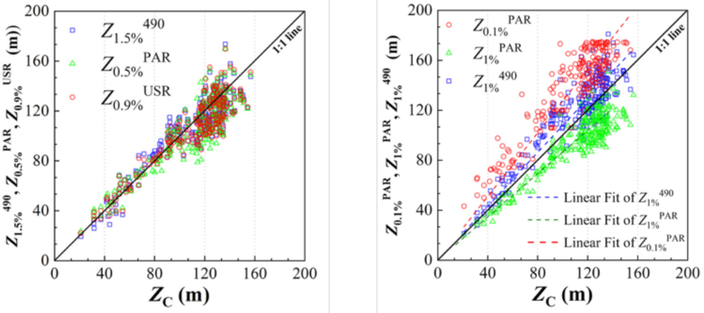
Scatterplots depict relationships between (left) Zc and Z0.9%USR, Z0.5%PAR, and Z1.5%490; (right) Zc and Z1%PAR, Z0.1%PAR, and Z1%490.
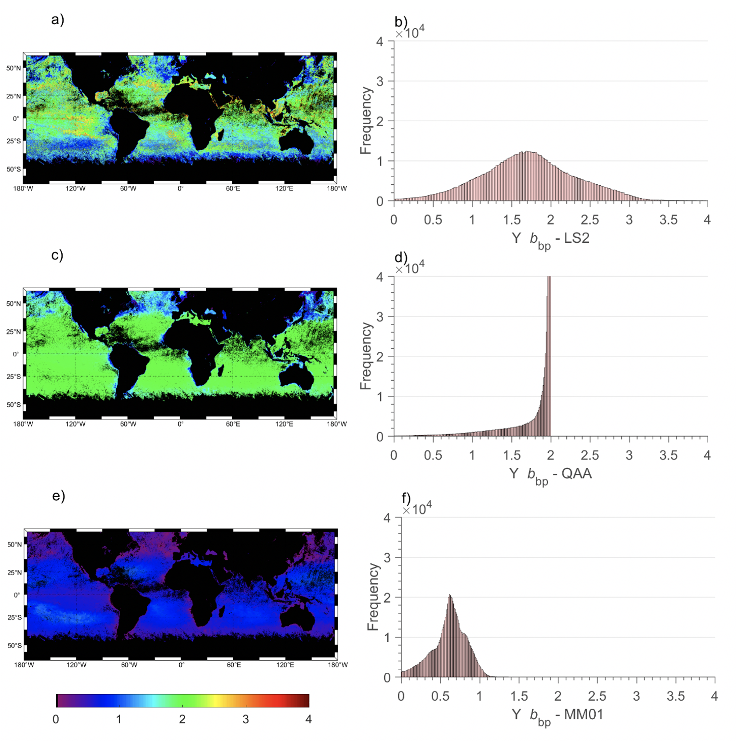
Global distribution of Ybbp (left column) and its corresponding histogram (right column) estimated from 3SAA, QAAv6 (Lee et al., 2009), and Morel and Maritorena (2001). In this latter algorithm, Chl-a is the standard OLCI product provided by the OC4Me algorithm (Morel et al., 2007).
Jorge et al. (2021) published a new research paper on an a three-step inverse model (3SAA) for estimating the inherent optical properties (IOPs) of surface waters from the remote sensing reflectance spectra, Rrs(λ). The derived IOPs include the total (a(λ)), phytoplankton (aphy(λ)), and colored detrital matter (acdm(λ)), absorption coefficients, and the total (bb(λ)) and particulate (bbp(λ)) backscattering coefficients. The first step uses an improved neural network approach to estimate the diffuse attenuation coefficient of downwelling irradiance from Rrs. a(λ) and bbp(λ) are then estimated using the LS2 model (Loisel et al., 2018). This later model allows to assess a much more dynamics bbp spectral slopes as other models which tend to saturate or to present much lower bbp spectral values (Figure 1). Then, an inverse optimization algorithm is combined with an optical water class (OWC) approach to assess aphy(λ) and acdm(λ) from anw(λ). The proposed model is evaluated using a large in situ dataset collected in open oceanic, coastal, and inland waters. Comparisons with other standard semi-analytical algorithms (QAA and GSM), as well as match-up exercises, have also been performed. The good performance of 3SAA is manifested by median absolute percentage differences (MAPD) of 13%, 23%, 34% and 34% for bbp(443), anw(443), aphy(443) and acdm(443), respectively for oceanic waters (Figure 2). Due to the absence of spectral constraints on IOPs in the inversion of total IOPs, and the adoption of an OWC-based approach, the performance of 3SAA is only slightly degraded in bio-optical complex inland waters. An excellent retrieval of bbp is achieved.
Employment Opportunities
Several new positions have been added to Employment Opportunities on the IOCCG website including:
- Two Permanent Earth Observation Scientist positions at ESA, The Netherlands
- Post Doctoral Fellow, Satellite Data Validation & Calibration, CNR-ISMAR, Rome
- Postdoctoral Research Associate – City College of New York/ Columbia University, USA
- Postdoctoral Position for Satellite Monitoring of Coral Reef Bleaching – Hawaii/Arizona, USA
- Two Postdoctoral positions at the University of Victoria, Canada
- Two positions: Biogeochemistry Research Assistant, and Ocean Biogeochemical Modeler at NASA GSFC, USA
- Two Postdoctoral positions (Global Ocean, Modelling, and Plankton Imaging and Machine Learning) at LOV, France
- Science Officer for Ocean Knowledge Action Network, France
- Postdoc Researcher – Harbor Branch Oceanographic Institute, FL, USA
- Satellite Data Analyst/Scientist, Royal Belgian Institute of Natural Sciences, Belgium
- Ph.D. Opportunities in Remote Sensing at Arizona State University, USA
For more information on these and other positions see http://ioccg.org/resources/employment-opportunities/.
