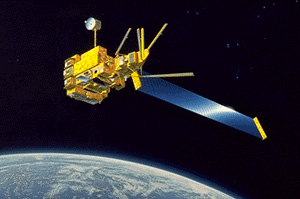
| AGENCY: | CNES (France) |
| SATELLITE: | ADEOS (Japan) |
| OPERATING DATES: | 17/08/96 – 01/07/97 |
| SWATH (km): | 2400 |
| RESOLUTION (km): | 6 |
| # OF BANDS: | 9 |
| SPECTRAL COVERAGE(nm): | 443-910 |
Data Sources:
POLDER News:
- POLDER 1 data reprocessed (IOCCG News, March 2003)
- POLDER Project has new set of Ocean-Colour Data (IOCCG News, November 2000)
- The Final reprocessing of POLDER 1 data was completed on November 2005, using new algorithms from POLDER-2 to achieve a consistent set of POLDER products for a total period of 15 months:
- 8 months for POLDER 1 from October 1996 to June 1997
- 7 months for POLDER 2 from April to October 2003
Information about algorithms, products and validation results can be found on the POLDER mission website at: http://smsc.cnes.fr/POLDER/A_produits_scie.htm.
The final scientific POLDER 1 and 2 ocean colour products are available on the POLDER website/order desk at: http://polder.cnes.fr. POLDER Publications:
Wang, M., Isaacman, A., Franz, B.A. and McClain, C.R. (2002). Ocean-color optical property data derived from the Japanese Ocean Color and Temperature Scanner and the French Polarization and Directionality of the Earth’s Reflectances: a comparison study. Appl. Optics,41(6): 974-990. [PDF file]
Franz, B., and Nicolas, J.-M. Selected Regional Comparisons with OCTS and POLDER
Takemata, K., and Kawata, Y. Land surface analysis by ADEOS/POLDER, Asian Conference on Remote Sensing, November 2001. [PDF file]
Fougnie, B., Deschamps, P.-Y., and Frouin, R. (1999). Vicarious calibration of the POLDER ocean color spectral bands using in situ measurements. IEEE Trans. Geosci. Rem. Sens., 37:1567-1574.
A. Lifermann, J.-M. Nicolas, P.-Y. Deschamps, F.-M. Breon, A. Bricaud and C. Moulin. POLDER and Ocean Color. backscatter, November 1998.
Deschamps, P.Y., Breon, F.M., Leroy, M., Podaire, A., Bricaud, A., Buriez, J.C., and Seze, G. (1994). The POLDER Mission : Instrument characteristics and scientific objectives. IEEE Transactions on Geoscience and Remote Sensing, 2(3): 598-615.
Bricaud A. Bosc E., Antoine D. (2002). Algal biomass and sea surface temperature in the Mediterranean Basin – Intercomparison of data from various satellite sensors, and implications for primary production estimates. Rem. Sens. Env., 81 (2-3): 163-178 August 2002. [PDF file]
Dupouy C., H. Loisel, J. Neveux, C. Moulin, S. Brown, J. Blanchot, A. Lebouteiller and M. Landry, (2003). Microbial absorption and backscattering coefficients from in-situ and POLDER satellite data during El Niño-Southern Oscillation cold Phase in the equatorial Pacific (180°). J. Geophys. Res.,108 (C12), 8138 [PDF file]
Loisel H., J.M. Nicolas, P.Y.Deschamps, and R. Frouin, (2002). Seasonal and inter-annual variability of the particulate matter in the global ocean. Geophys. Res. Lett. 29, 2996. [PDF file]
POLDER Links:
- POLDER mission Website
- Remote Sensing Using Multi-spectral, Multiangle Polarized POLDER Data, Center for Spatial Technologies and Remote Sensing (CSTARS)


 The sixth International Ocean Colour Science (IOCS) meeting will take place in Darmstadt, Germany from 1 – 4 December 2025, hosted by EUMETSAT and ESA with support from other agencies.
