Click on the photograph to see a larger version.

Click on the photograph to see a larger version.
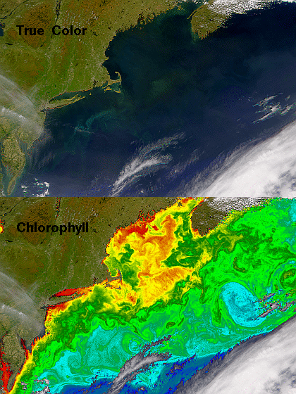
On May 11, 2002 clear skies revealed the highly productive waters off the eastern United States and Canada to the SeaWiFS radiometer. The two images provided here are derived from the same raw data, but are processed in different ways.
The first image is a quasi-true-colour view formed by using the red, green, and blue spectral bands from the sensor as the red, green, and blue components of the image. The second image is a pseudo-colour representation of sea surface chlorophyll concentrations overlaid on the quasi-true-colour image.
You will note that the chlorophyll image brings out much more of the complexity in this part of the Atlantic Ocean. In this view the waters over Georges Bank and in the Gulf of Maine exhibit the high chlorophyll concentrations that mark thriving phytoplankton populations which are the base of the food web for most of the rest of those ecosystems. To the south, chlorophyll concentrations decrease rapidly as one crosses the northern boundary of the meandering Gulf Stream. To the east of Georges Bank one of the meanders has pinched off into a large warm core ring.
One thing that the chlorophyll concentration data do not tell us is how different species of phytoplankton are distributed in an area. You can get some sense of this by looking at the quasi-true-colour image and noting that the colours of the various blooms differ from each other. To the southeast of Long Island we see an aquamarine hue. Over the top of Georges Bank the colour is more yellow-green. Around the edge of the Bank and in the middle of the Gulf of Maine, a reddish tinge is visible. These colour differences likely reflect differences in species composition and in depth distributions of the cells whose pigments and light scattering characteristics are detected by the orbiting SeaWiFS.
Provided by the SeaWiFS Project, NASA/Goddard Space Flight Center, and ORBIMAGE.
For more information on, and links to SeaWiFS, click here.